| Kant Air Base |
| IATA: none – ICAO: UAFW |
| Summary |
| Airport type |
Public / Military |
| Operator |
Russian Air Force |
| Location |
Kant, Kyrgyzstan |
| Elevation AMSL |
2,549 ft / 777 m |
| Coordinates |
42°51′11″N 074°50′47″E / 42.85306°N 74.84639°E / 42.85306; 74.84639 |
| Runways |
| Direction |
Length |
Surface |
| m |
ft |
| 11/29 |
2,700 |
8,859 |
Concrete |
| Source: DAFIF |
Kant Air Base (Russian: Авиабаза Кант Aviabaza Kant) is a military air base in Ysyk-Ata District of Chuy Oblast in Kyrgyzstan. It is located just south of the city of Kant, some 20 km east of downtown Bishkek. History
In 1941, a Soviet Air Force base and pilot training school were set up near the city of Kant, based on a school evacuated from Odessa.
During World War II, 1507 Soviet military pilots were trained there and from 1956. The school also trained foreign pilots. Among its graduates were Egyptian president Hosni Mubarak and the late Syrian president Hafez al-Assad, as well as India's Air Chief Marshal Dilbagh Singh and South Yemen Brigadier Pilot Shakeeb Khobani.
In 1992, following the collapse of the Soviet Union, control of the air base was transferred to Kyrgyzstan.
Present-day Russian base
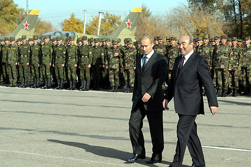 | |
Former presidents Vladimir Putin and Askar Akayev at Kant Air Base |
In accordance with a bilateral agreement between Russia and Kyrgyzstan signed on 22 September 2003, the air base hosts Russian Air Force units. The official opening took place on 23 October 2003, making the facility the first new air base Russia opened abroad since 1991. The unit stationed there has been described as Russian Air Force's 5th Air Army's 999th Air Base.
The above content comes from Wikipedia and is published under free licenses – click here to read more.
| General Info
|
| Country |
Kyrgyzstan
|
| ICAO ID |
UAFW
|
| Time |
UTC+5(+6DT)
|
| Latitude |
42.853236
42° 51' 11.65" N
|
| Longitude |
74.846533
074° 50' 47.52" E
|
| Elevation |
2549 feet
777 meters
|
| Type |
Joint (Civil and Military)
|
| Magnetic Variation |
005° E (01/06)
|
| Operating Agency |
MILITARY - CIVIL JOINT USE AIRPORT
|
| Operating Hours |
24 HOUR OPERATIONS
|
| Communications
|
| TWR |
124.0
|
| BISHKEK APP |
124.6
|
| Runways
|
| ID |
Dimensions |
Surface |
PCN |
ILS
|
| 11/29 |
8859 x 164 feet
2700 x 50 meters |
CONCRETE. |
027RBXT |
NO
|
| Navaids
|
| Type |
ID |
Name |
Channel |
Freq |
Distance From Field |
Bearing From Navaid
|
| VOR-DME |
MNS |
BISHKEK |
081X |
113.4 |
9.9 NM |
126.9
|
| NDB |
PD |
KANT |
- |
568 |
3.4 NM |
111.7
|
| Supplies/Equipment
|
| Fuel |
Jet A1, without icing nhibitor.
|
The content above was published at Airports-Worldwide.com in 2020.
We don't guarantee the information is fresh and accurate. The data may be wrong or outdated.
For more up-to-date information please refer to other sources.
|

![Kyrgyz
Kyrgyzstani[2] airports - Kant Airport](../img/air-fly-D2.gif)


