|
 |
|
||||
|
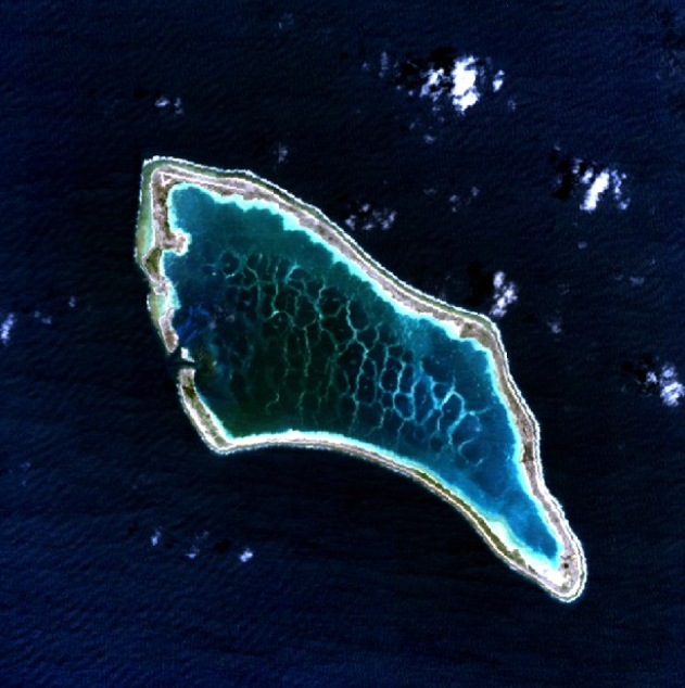
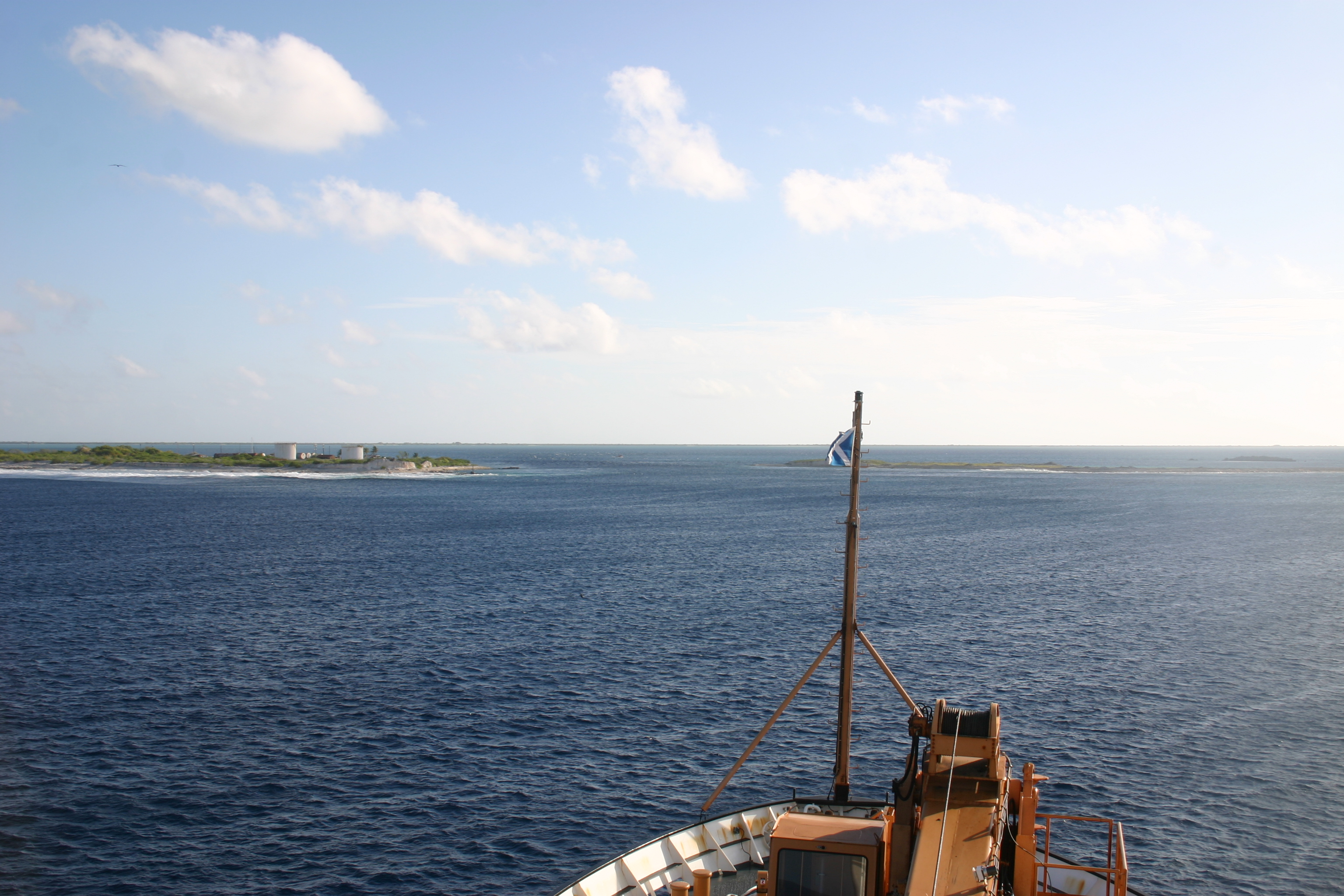
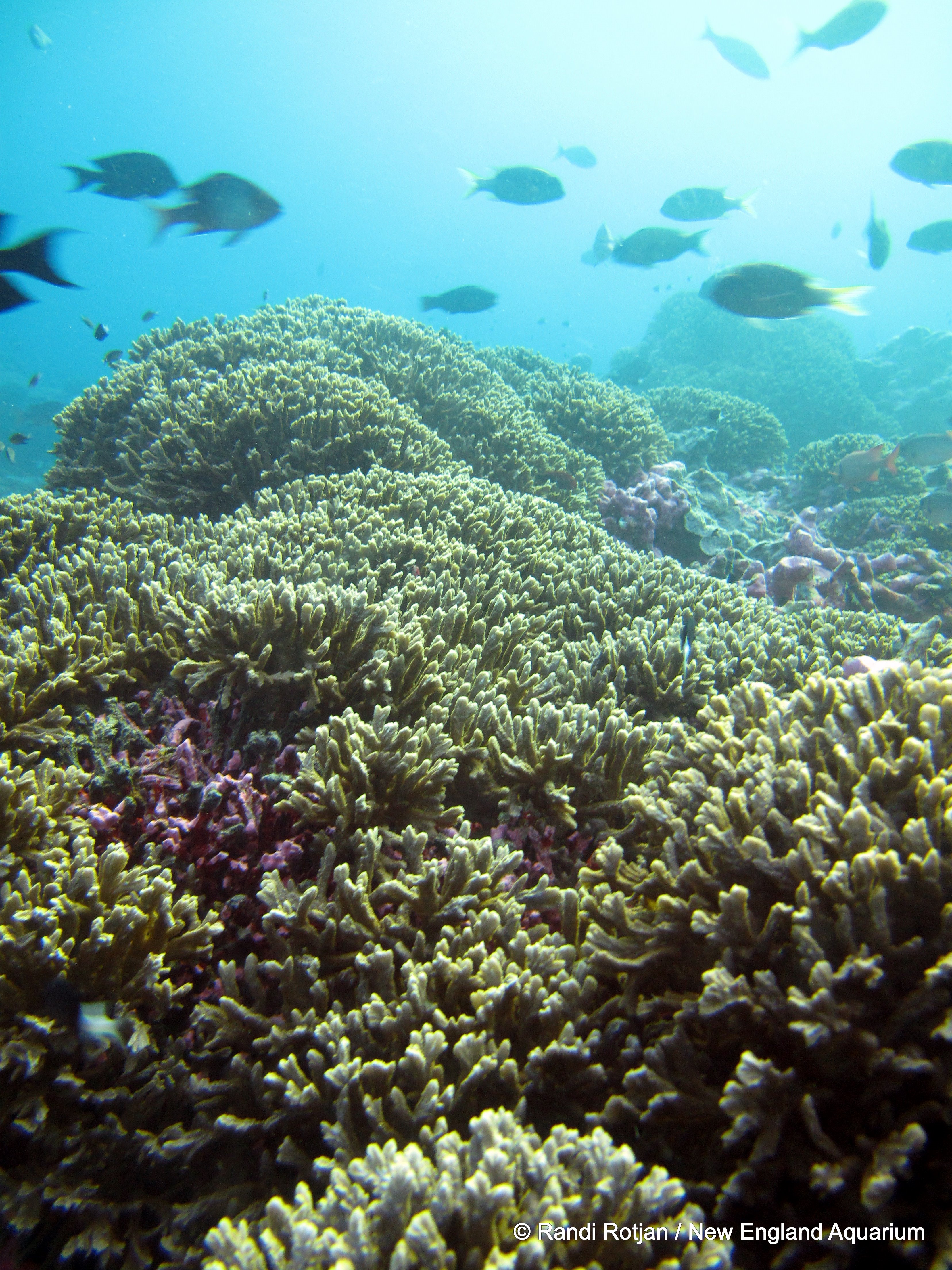
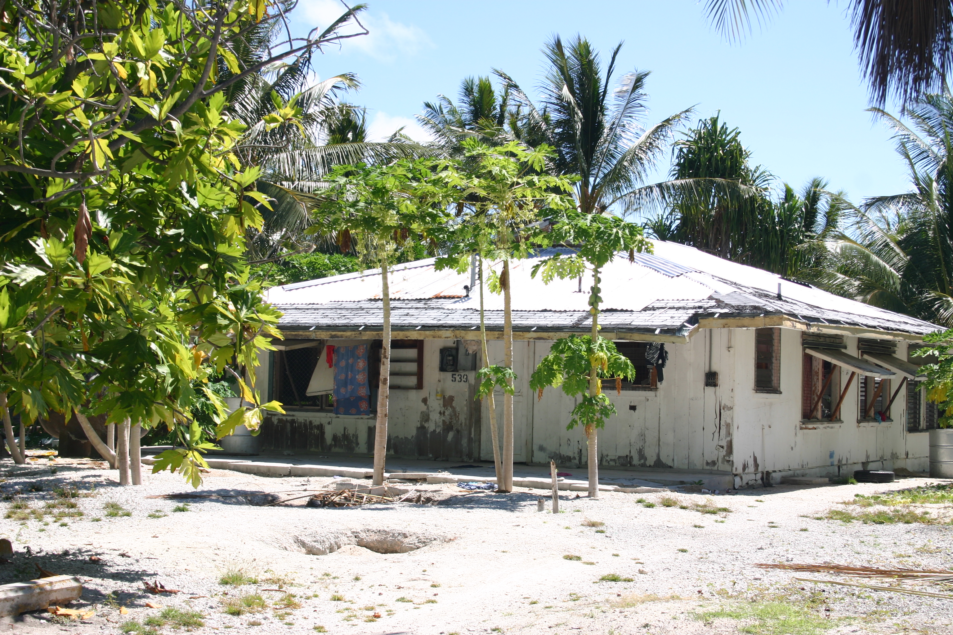
Kanton Island (also known as Canton Island or Abariringa Island), alternatively known as "Mary Island", "Mary Balcout's Island" or "Swallow Island", is the largest, northernmost, and as of 2007, the sole inhabited island of the Phoenix Islands, in the Republic of Kiribati. It is an atoll located in the South Pacific Ocean roughly halfway between Hawaii and Fiji at 2°50′S 171°40′W / 2.833°S 171.667°W. The island is a narrow ribbon of land enclosing a lagoon with an area of 40 square kilometers. Kanton's closest neighbor is the uninhabited island of Enderbury, 63 km to the south. The capital of Kiribati, South Tarawa, lies 1,765 km to the west. As of 2005, the population was 41, down from 61 in 2000. In May 2010 the population was reportedly 24, with 14 adults and 10 children. The island's sole village is called Tebaronga. Discovery and namingKanton Island was discovered on August 5, 1824, by two London whaling ships: the Phoenix, Capt. John Palmer; and the Mary, Capt. Edward Reed. The atoll was initially named "Mary Ballcout's Island" after the shipowner's wife. Kanton got its permanent name from the New Bedford whaler Canton, which ran aground on the atoll on March 4, 1854, while under the command of Capt. Andrew Wing. The crew managed to escape on whaleboats and after an open-water voyage of 49 days, reached Tinian Island in the Marianas, without the loss of a man. Three of the survivors, including Capt. Wing and Thomas E. Braley settled in Acushnet, Massachusetts. Geography, flora and faunaKanton has been described as being shaped like a large pork chop. From its northwest to southeast points is a distance of 14.5 km (9.0 mi), while the land rim varies in width from 50–600 m (160–2,000 ft) and 1.5–7 m (4.9–23 ft) in elevation. The southeast corner of the island is known as "Pyramid Point." The sole entrances to the lagoon are on the west side, with the main channel exhibiting currents of 6–8 knots (3.1–4.1 m/s). The lagoon itself is filled with marine life, holding 153 different species of fish, including tuna, sharks, stingrays and eels. An unpaved road runs around the island, though its current state of repair is uncertain. The northwestern corner of the island holds a functional (as of 2003) airport, which has its own ICAO and IATA codes, but currently lacks any international or inter-island service. The World Port Index number of Kanton Island is 56025 .
Much of Kanton's land surface is bare coral, sparsely covered with herbs and low bunch grass; a few trees and bushes are found near the village site. According to Edwin H. Bryan's American Polynesia and the Hawaiian Chain, Kanton possessed in 1941 a total of twelve native species of vegetation, including low herbs and bunch grass, a thick stand of Scaevola shrubs on the island's south side (2–3 m/6.6–9.8 ft high), some Suriana maritima shrubs near the lagoon entrance, heliotrope (Heliotropium foertherianum) and kou (Cordia subcordata) trees, and coconut palms. In 1937, the New Zealand eclipse expedition reported 23 bird species on Kanton, together with Polynesian Rats, lizards, hermit crabs and turtles. Two species of spiders were found on the island.
There is no freshwater on Kanton, which is a problem for settlers. Rainwater is caught in cisterns; Pan American had a large distillation plant on the island when it operated there during the 1940s and 50's. Rainfall is sparse, averaging 8.71–35.97 in (22.1–91.4 cm) between 1938 and 1953, though later reports suggest a wetter climate in recent years. HistoryBritish claimsThe British laid claim to Kanton Island during the 1850s. The official British claim was formally reasserted on August 6, 1936, with the British making several visits to the island culminating in the placement of two radio operators on Kanton on August 31, 1937. Americans arrive
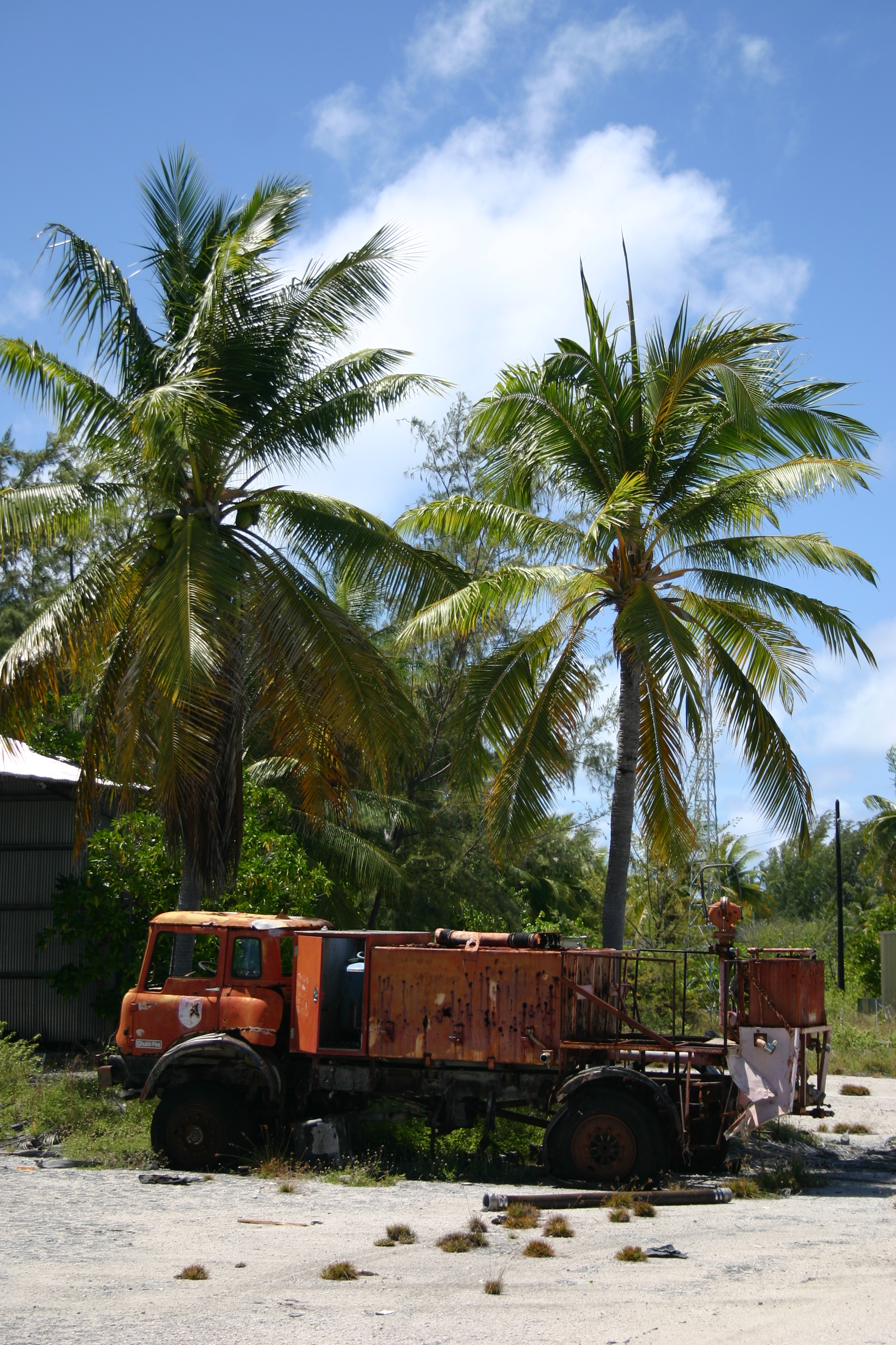
On July 8, 1937, Kanton was the site of a total solar eclipse and the island was occupied briefly by American and New Zealand scientists, members of an expedition organized by the National Geographic Society and led by the astronomer Samuel Alfred Mitchell. During this time, the American party claimed the island for the United States, erecting a small monument with two American flags. According to one account, the British warship HMS Wellington fired a shot across the bow of the USS Avocet, when the latter refused to cede the choicest anchorage spot to the British vessel. The American ship allegedly responded in kind, following which both captains agreed to "cease fire" until instructions could be received from their respective governnments. Washington and London quickly ordered no further escalation, and both parties observed the solar eclipse together, "though officially a bit cool." In response to the British reoccupation of Kanton in August 1937, seven Americans landed on the island on March 7, 1938. Although the British ambassador to the United States requested removal of markers claiming U.S. sovereignty, President Franklin Roosevelt formally placed the island under control of the U.S. Interior department on March 3, 1938. Both parties continued to press their competing claims until April 6, 1939, when the U.S. and Britain agreed to hold Kanton under joint control for the next forty years as the Canton and Enderbury Islands condominium. The U.S./U.K. tenure proved cordial and cooperative thereafter, with each party enjoying the other's hospitality and working together to ensure smooth operation of island facilities. Airplane oasisPan American World Airways arrived on Kanton on May 18, 1939, to build facilities for their planned New Zealand flying boat service. Service commenced on July 12, 1940 with the Boeing 314 Clipper. On December 4, 1941, the Pacific Clipper departed Kanton for New Caledonia as the final civilian flight before the war. World War IIDuring World War II the United States Navy built a 6,230 foot (1.9 km) airstrip at 2°46′05″S 171°42′37″W / 2.76806°S 171.71028°W (IATA: CIS, ICAO: PCIS). Kanton became a stopover point for the Navy Air Transport Service flights to Australia and New Zealand as well as a staging point for attacks on the Gilbert Islands, then held by Japan. The USS President Taylor was grounded and abandoned near the island on 14 February 1942 when disembarking troops. It was shelled three times in late 1942 by Japanese submarines, and bombed once on March 25, 1943. Damage was reported as "slight." The island was defended by approximately 1,200 combat troops and support personnel, but was never attacked by Japanese forces. It was the site of at least two airplane crashes during the war: on 19 July 1944 and 5 December 1945. After the war moved west, it became the homebase for the Roman Catholic chaplain in this area of the Pacific. In November 1946, Pan Am resumed service to Australia and New Zealand via Kanton with Douglas DC-4 aircraft. British Commonwealth Pacific Airlines, Australia's first trans-Pacific airline, used the island as a stopover on the way to Hawaii, flying luxurious DC-6Bs on the Sydney to Vancouver BC, Canada route. Qantas took over this service shortly thereafter, after BCPA went out of business. Canadian Pacific Airlines used the island as well. This service continued through 1958, when the DC-4's were replaced with the Douglas DC-7C. A full-scale community was established to support these operations, including an electrical power station, a hotel for the airline passengers' use, a medical dispensary, school for dependent children of station personnel, and other necessary facilities. The island was jointly administered by the United Kingdom and the United States, and the British and American post offices were both operated from a single building. The American administrator, who was an employee of the Civil Aeronautics Administration (predecessor to the FAA) and island manager for that agency, also served as the U.S. resident administrator under the Department of the Interior and as a U.S. special deputy marshal under the Department of Justice. William J. Evans held this position from 1952–1956, during which time a crew from National Geographic magazine visited the island and highlighted it in the magazine's January 1955 issue. Ultimately, the introduction of long-range jet aircraft spelled the end of Kanton's usefulness as an aircraft refueling station, and all airlines ended their operations there by the late 1950s—except for Pan Am, which continued a monthly service with DC-7C aircraft via Auckland, Nadi, Pago Pago, Kanton, Honolulu and return. This service was conducted using the outbased DC-7C aircraft N743PA and N744PA, which provided feeder service from Auckland to three points on the jet service schedules. The last Pan Am flight was in November 1965 when the final DC-7C returned to Miami after the opening of a new airport in Auckland, enabling New Zealand to be added to Pan Am's jet routes. Kanton's airport remained operational, however, as an emergency landing field.
After the airlinesIn 1960 a tracking station for the Mercury program was built on Kanton. It was utilized through November 1965. The U.S. Air Force and the U.S. Space and Missile Systems Organization continued to use the island for missile-tracking operations through 1976. That year marked the complete end of the American presence; the airfield was abandoned and all U.S. personnel were removed. The British also closed their post office, ending their presence on Kanton as well. With the independence of Kiribati from Britain in 1979, the Anglo-American condominium was formally terminated, and the island transferred to Kiribati sovereignty. Kanton's post office was reopened by the Kiribati government, and the island was repopulated with a few people from the more crowded atolls of the Gilbert Islands, who reside in several of the abandoned residences left over from the Anglo-American presence. Kanton is occasionally visited by Republic of Kiribati vessels, the U.S. Coast Guard and various fishing boats. In 2008, Kanton and the rest of the Phoenix Islands became the Phoenix Islands Protected Area (PIPA), the world's largest marine protected area, covering a total area of 410,500 square kilometers of land and ocean. In 2007 it was submitted, together with the rest of the PIPA, as a UNESCO World Heritage site . In 2010 Alex Bond, a sailor delivering a yacht from Cornwall to Australia, stopped off at Kanton while sailing from Honolulu to Fiji. He discovered the 24 islanders (14 adults and 10 children) were dangerously short of food. An expected supply ship had not arrived and they had been living on fish and coconuts for several months. Bond used his satellite phone to contact the UK Coastguard at Falmouth, Cornwall, who contacted the US Coast Guard to arrange relief supplies. The above content comes from Wikipedia and is published under free licenses – click here to read more.
The content above was published at Airports-Worldwide.com in 2010. |
|||||||||||||||||||||||||||||||||||||||||||||||||||||||||||||||||||||||||||||||||||||

 |
|
Copyright 2004-2026 © by Airports-Worldwide.com, Vyshenskoho st. 36, Lviv 79010, Ukraine Legal Disclaimer |