|
|
Komatsu Airport
Kanazawa/Komatsu Airport
小松飛行場
Komatsu Hikōjō |
 |
| IATA: KMQ – ICAO: RJNK |
| Summary |
| Airport type |
Military/Public |
| Operator |
Ishikawa Prefecture / JASDF |
| Location |
Komatsu, Ishikawa, Japan |
| Elevation AMSL |
22 ft / 7 m |
| Coordinates |
36°23′38″N 136°24′27″E / 36.39389°N 136.4075°E / 36.39389; 136.4075 (Komatsu Airport)Coordinates: 36°23′38″N 136°24′27″E / 36.39389°N 136.4075°E / 36.39389; 136.4075 (Komatsu Airport) |
| Website |
www.pref.ishikawa.jp/... |
| Runways |
| Direction |
Length |
Surface |
| m |
ft |
| 06/24 |
2,700 |
8,858 |
Concrete |
| Source: Japanese AIP at AIS Japan |
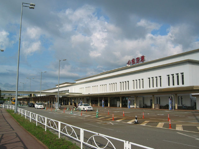
Komatsu Airport (小松飛行場, Komatsu Hikōjō) (IATA: KMQ, ICAO: RJNK) is an airport located 4.2 km (2.6 mi) west southwest of Komatsu Station in the city of Komatsu, Ishikawa Prefecture, Japan. It serves the southern Ishikawa Prefecture including the capital Kanazawa (which has its IATA city code QKW), and the northern Fukui Prefecture including the capital Fukui. Overview
Japan Air Self-Defense Force Komatsu Base shares its runways with civil aviation. Its taxiways are on both sides of the runway. The inland-side taxiway is used by the JASDF and the sea-side one is used by the civil terminal. The airport is served by Boeing 747-sized airliners and is the largest airport in the Hokuriku region. It is equipped with an ILS, allowing fewer cancellation of services during the snowy winter months.
Its runway surface has been completed strengthening upgrades to enable non-stop freighter flights to and from Europe and North America in late 2006.
Passenger Facilities
- Domestic Terminal Building
- International Terminal Building
- Operated by Hokuriku Air Terminal Building K.K.
Cargo Facilities
- HIACT (Hokuriku International Air Cargo Terminal)
- International Cargo Building 1
- International Cargo Building 2
- Domestic Cargo Building
Other Facilities
- Komatsu Airport Office, Ōsaka Air Transportation Bureau.
- Komatsu Office, Air Transportation Security Association.
- Fire and Disaster Mitigation Office, Ishikawa Prefectural Government.
- Equipped with Bell 412EP fire and disaster mitigation helicopter "Hakusan".
- Komatsu Operations Office, Nakanihon Air Service
- A helicopter is based here.
Japan Air Self-Defence Force Komatsu Base
Komatsu Airbase (小松基地, Komatsu Kichi) is an airbase of Japan Self-Defense Force opened in February 1961.
The "Airspace G" is a large training airspace over the Sea of Japan to the north of the base.
In the Kōkū-sai (Air Festival) held every September features demo flights by fighters and rescuers based in Komatsu as well as the Blue Impulse acrobat flight team.
It often hosts technical competitions of the JASDF.
History
- 1943 Construction begins as the airport for the Japanese Imperial Navy Maizuru headquarters.
- 1944 Construction complete. with east-west 1,500 m (4,921 ft) and north-south 1,700 m (5,577 ft).
- November 1945 Annexed by United States of America and became an auxially radar base.
- 1955 Non-scheduled routes serving to Osaka by Nippon Helicopter Yuso (currently All Nippon Airways).
- February 1958 Returned from the United States.
- 1960 The runway was extended to 2,400 m (7,874 ft). Designated as a shared airport for defense and civil.
- February 1961 JASDF Komatsu Base was opened.
- 1962 Scheduled civil service began.
- 1964 The runway was extended to 2,700 m (8,858 ft) to introduce F-104J.
- 1973 Jet service began with Boeing 737s.
- 1979 International scheduled service to Seoul began.
- 1980 B747s were introduced to Tokyo
- 1981 The new domestic terminal complete.
- 1984 The new international terminal complete.
- 1994 HIACT(International Cargo Building)complete. Designated as a Free Access Zone.
- 1994 Cargolux began international scheduled freight service between Luxembourg.
- 2002 The new HIACT termial complete.
- 2004 The new control tower began operations.
- 2005 The temporary runway began operation.
- 2006 Upgrading of the permanent runway complete. Operations switched to the permanent runway.
- 2007 USAF F-15C, C-17 came for JASDF joint training.
- 2007 A new domestic cargo building opens.
Statistics
| Year |
Total Passengers |
| 2000 |
2,587,941 |
| 2001 |
2,590,333 |
| 2002 |
2,645,038 |
| 2003 |
2,599,706 |
| 2004 |
2,495,837 |
Acceptance of training United States Air Force
In July 2006, The mayor of Komatsu city told the chief of Japan Defense Agency (now the Minister of Defense) the city would accept training of the USAF aircraft. The neighbouring municipalities also officially announced the acceptance. USAF aircraft came on 16 May 2007 for a joint training with the JASDF.
Airlines and destinations
Domestic
| Airlines |
Destinations |
| All Nippon Airways operated by Air Nippon |
Fukuoka, Sapporo-Chitose, Sendai, Tokyo-Haneda |
| All Nippon Airways operated by Ibex Airlines |
Tokyo-Narita |
| Fuji Dream Airlines |
Shizuoka |
| Japan Airlines |
Matushima [begins 1 June 2010], Tokyo-Haneda |
| Japan Airlines operated by Japan Transocean Air |
Naha |
International
| Airlines |
Destinations |
| All Nippon Airways |
Taipei-Taiwan Taoyuan |
| China Eastern Airlines |
Shanghai-Pudong |
| EVA Air |
Taipei-Taiwan Taoyuan |
| Korean Air |
Seoul-Incheon |
Cargo
- Cargolux operates scheduled B747-400F flights between Luxemburg with some stops from New Chitose, Hong Kong, Taipei, Fairbanks, Dubai and Abu Dhabi.
Access
- Kanazawa: 30 minutes by car. Scheduled buses are available.
- Komatsu Interchange of Hokuriku Expressway.
- Kanazawa Station: 40 minutes by bus.
- Komatsu Station: 15 minutes by bus.
- Kaga-onsen Station: 25 minutes by bus, stopping at Katayamatsu onsen.
- Fukui, Fukui: 45 minutes by car.
- Katayamatsu Interchange of Hokuriku Expressway.
- JR Fukui Station: 60 minutes by bus.
The above content comes from Wikipedia and is published under free licenses – click here to read more.
| General Info
|
| Country |
Japan
|
| ICAO ID |
RJNK
|
| Time |
UTC+9
|
| Latitude |
36.394611
36° 23' 40.60" N
|
| Longitude |
136.406544
136° 24' 23.56" E
|
| Elevation |
36 feet
11 meters
|
| Type |
Joint (Civil and Military)
|
| Magnetic Variation |
007° W (01/06)
|
| Beacon |
Yes
|
| Operating Agency |
MILITARY - CIVIL JOINT USE AIRPORT
|
| Island Group |
Honshu I
|
| Operating Hours |
24 HOUR OPERATIONS
|
| Communications
|
| TWR |
118.25
126.2
236.8
304.8
|
TCA
Opr 2300-1100Z Mon-Fri.
|
127.95
292.2
|
| GND |
121.7
275.8
|
| DEP |
120.1
362.3
121.25
|
| APP |
120.1
121.25
|
| Communications Remarks |
|
| TWR |
(123.1x 138.05 247.0x for rescue only.)
|
| Runways
|
| ID |
Dimensions |
Surface |
PCN |
ILS
|
06/24
CLOSED |
8860 x 150 feet
2701 x 46 meters |
PART CONCRETE, PART ASPHALT, OR PART BITUMEN-BOUND MACADAM. |
- |
YES
|
| 06T/24T |
8876 x 148 feet
2705 x 45 meters |
ASPHALT |
063FBXT |
NO
|
| Navaids
|
| Type |
ID |
Name |
Channel |
Freq |
Distance From Field |
Bearing From Navaid
|
| VORTAC |
KMC |
KOMATSU |
057X |
112 |
At Field |
-
|
| Remarks
|
| CAUTION |
W portion of parl twy not vis from twr.
|
| FUEL |
(NC-A1)
|
| JASU |
(C-3) (JEAS) (KM-3)
|
| LGT |
Rwy 06-24 PAPI GS 2.5 , MEHT Rwy 06-24 66'.
|
| RSTD |
PPR for civ tran acft, exc copter. Tran acft rstd btn 0300-0400Z, exc emerg, fornoise abatement. Rwy 06-24 CLSD for const. Parallel twy now being used as temp Rwy 06T-24T. CSTMS/AG/IMG - avbl H24.
|
| TRAN ALERT |
No storage. Svcg delay for tran acft.
|
The content above was published at Airports-Worldwide.com in 2010.
We don't guarantee the information is fresh and accurate. The data may be wrong or outdated.
For more up-to-date information please refer to other sources.
|
|