 |
 |
|
||||
|
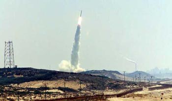
Blast off ... a rocket carrying Israel's new-generation spy satellite Ofek 6 takes off from Palmahim, south of Tel Aviv. Photo: AFP Images and information placed above are from
Runway 03/217884 x 98 feet
|
|||||||||||||||||||||||||||||||||||||||||||||||||||||||||||||||||||||||||||||||||||||||||||||||||||||||||||||||||||||||||||||||||||||||||||||||
| Runway 03 | |
|---|---|
| Surface | ASPHALT |
| True Heading | 025.0 |
| Latitude | 31.891861 31° 53' 30.70" N |
| Longitude | 34.687469 034° 41' 14.89" E |
| Landing Distance | 7884 feet 2403 meters |
| Takeoff Distance | 7884 feet 2403 meters |
| Lighting System | LIRL |
| Runway 21 | |
|---|---|
| Surface | ASPHALT |
| True Heading | 205.0 |
| Latitude | 31.911508 31° 54' 41.43" N |
| Longitude | 34.698197 034° 41' 53.51" E |
| Landing Distance | 7884 feet 2403 meters |
| Takeoff Distance | 8054 feet 2455 meters |
| Overrun Length | 170 feet 52 meters |
| Overrun Surface | ASPHALT |
| Lighting System | LIRL |
| Runway 13 | |
|---|---|
| Surface | ASPHALT |
| True Heading | 127.0 |
| Latitude | 31.900303 31° 54' 01.09" N |
| Longitude | 34.687186 034° 41' 13.87" E |
| Landing Distance | 2636 feet 803 meters |
| Takeoff Distance | 2636 feet 803 meters |
| Runway 31 | |
|---|---|
| Surface | ASPHALT |
| True Heading | 307.0 |
| Latitude | 31.895906 31° 53' 45.26" N |
| Longitude | 34.693914 034° 41' 38.09" E |
| Landing Distance | 2636 feet 803 meters |
| Takeoff Distance | 2636 feet 803 meters |
The content above was published at Airports-Worldwide.com in 2005.
We don't guarantee the information is fresh and accurate. The data may be wrong or outdated.
For more up-to-date information please refer to other sources.

 |
|
Copyright 2004-2026 © by Airports-Worldwide.com, Vyshenskoho st. 36, Lviv 79010, Ukraine Legal Disclaimer |
 Military
Israeli Air Base
Military
Israeli Air Base