 |
 |
|
||||
|
History Previously, charter flights from Europe landed at Etzion Airport, which was one of three airports in Sinai that were handed over to the Egyptians, after the signing of the peace treaty.
In 1988 a decision was taken whereby international flights bringing tourists
to Eilat would land at Ovda, instead of at Eilat. This facilitated the
operation of large, wide-bodied craft, such as the 747 Jumbo, which cannot
operate from Eilat Airport. Since then, the majority of international
flights land at Ovda instead of at Eilat. The runway at Ovda allows long
range flights to take off for any European destination, without the need
to refuel at BGIA. Airport Managing Director Fax (08) 636-3829 Control Tower (08) 636-3804 WEB: http://www.iaa gov il/Rashat/en-US/Airports/ovda/ E-mail: telmas at iaa gov il
Images and information placed above are from
Runway 02R/20L9843 x 148 feet
|
|||||||||||||||||||||||||||||||||||||||||||||||||||||||||||||||||||||||||||||||||||||||||||||||||||||||||||||||||||||||||||||||||||||||||||||||||||||||||||||||||||||||||||||||||||||||||||||||||||||||||||||||||||||||||||||||||||||||||||||||||||||||||||||||||||||||||||||||||||||
| Runway 02R | |
|---|---|
| Surface | ASPHALT |
| True Heading | 022.0 |
| Latitude | 29.927164 29° 55' 37.79" N |
| Longitude | 34.931731 034° 55' 54.23" E |
| Elevation | 1492.0 feet 455 meters |
| Slope | -0.7° |
| Landing Distance | 9351 feet 2850 meters |
| Takeoff Distance | 10400 feet 3170 meters |
| Displaced Threshold Length | 492 feet 150 meters |
| Overrun Length | 557 feet 170 meters |
| Overrun Surface | ASPHALT |
| Lighting System | HIRL |
| Runway 20L | |
|---|---|
| Surface | ASPHALT |
| True Heading | 202.0 |
| Latitude | 29.952150 29° 57' 07.74" N |
| Longitude | 34.943342 034° 56' 36.03" E |
| Elevation | 1424.0 feet 434 meters |
| Slope | 0.7° |
| Landing Distance | 9351 feet 2850 meters |
| Takeoff Distance | 10400 feet 3170 meters |
| Displaced Threshold Length | 492 feet 150 meters |
| Overrun Length | 557 feet 170 meters |
| Overrun Surface | ASPHALT |
| Lighting System | HIRL |
| Runway 02L | |
|---|---|
| Surface | ASPHALT |
| True Heading | 022.0 |
| Latitude | 29.930028 29° 55' 48.10" N |
| Longitude | 34.929119 034° 55' 44.83" E |
| Elevation | 1488.0 feet 454 meters |
| Slope | -0.7° |
| Landing Distance | 8038 feet 2450 meters |
| Takeoff Distance | 8727 feet 2660 meters |
| Displaced Threshold Length | 492 feet 150 meters |
| Overrun Length | 197 feet 60 meters |
| Overrun Surface | ASPHALT |
| Lighting System | HIRL
REIL A2 PAPI |
| Runway 20R | |
|---|---|
| Surface | ASPHALT |
| True Heading | 202.0 |
| Latitude | 29.951661 29° 57' 05.98" N |
| Longitude | 34.939203 034° 56' 21.13" E |
| Elevation | 1432.0 feet 436 meters |
| Slope | 0.7° |
| Landing Distance | 8038 feet 2450 meters |
| Takeoff Distance | 8727 feet 2660 meters |
| Displaced Threshold Length | 492 feet 150 meters |
| Overrun Length | 197 feet 60 meters |
| Overrun Surface | ASPHALT |
| Lighting System | HIRL
A2 PAPI |
| OVDA | |||||
|---|---|---|---|---|---|
| Type | ID | Channel | Freq | Country | State |
| VOR-DME | OVD | 088X | 114.1 | Israel | - |
| Latitude | Longitude | Airport |
| 29.966667 29° 58' 00.00" N |
34.947222 034° 56' 50.00" E |
LLOV |
| OVDA | |||||
|---|---|---|---|---|---|
| Type | ID | Channel | Freq | Country | State |
| NDB | OVD | - | 353 | Israel | - |
| Latitude | Longitude | Airport |
| 29.942222 29° 56' 32.00" N |
34.933056 034° 55' 59.00" E |
LLOV |
The content above was published at Airports-Worldwide.com in 2005.
We don't guarantee the information is fresh and accurate. The data may be wrong or outdated.
For more up-to-date information please refer to other sources.

 |
|
Copyright 2004-2026 © by Airports-Worldwide.com, Vyshenskoho st. 36, Lviv 79010, Ukraine Legal Disclaimer |
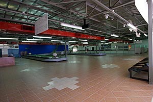
 The flights landing at Ovda Airport arrive mainly from European destinations.
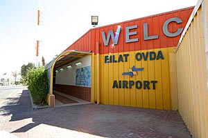
 A
civilian terminal was built at Ovda Airport, located 60 km north of Eilat,
which began handling direct charter flights from Europe.
A
civilian terminal was built at Ovda Airport, located 60 km north of Eilat,
which began handling direct charter flights from Europe.