|
|
Coordinates: 10°10′17″S 123°40′16″E / 10.17139°S 123.67111°E / -10.17139; 123.67111
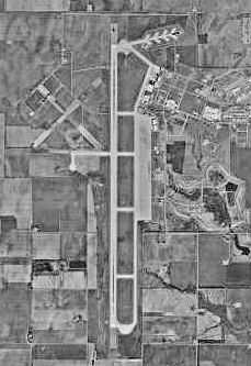
| El Tari Airport |
 |
| IATA: KOE – ICAO: WATT |
| Summary |
| Airport type |
Public / Military |
| Operator |
PT Angkasa Pura I |
| Location |
Kupang, East Nusa Tenggara, Indonesia |
| Elevation AMSL |
335 ft / 102 m |
| Runways |
| Direction |
Length |
Surface |
| ft |
m |
| 07/25 |
8,202 |
2,500 |
Asphalt |
| 12/30 |
4,175 |
1,273 |
Dirt/Grass |
| Source: World Aero Data |
El Tari Airport or Eltari Airport (IATA: KOE, ICAO: WATT) is an airport in Kupang, East Nusa Tenggara, Indonesia. The airport's ICAO code was changed from WRKK to WATT in 2004. Airlines and destinations
| Airlines |
Destinations |
| Batavia Air |
Surabaya |
| Garuda Indonesia |
Denpasar, Jakarta |
| Garuda operated by Citilink |
Surabaya |
| Lion Air |
Surabaya |
| Mandala Airlines |
Surabaya |
| Merpati Nusantara Airlines |
Alor, Denpasar, Ende, Merauke |
| Pelita Air Service |
Ende, Maumere |
| Sriwijaya Air |
Surabaya |
Accidents and incidents
- On 27 November 2009, Batavia Air Flight 711, operated by a Boeing 737-400 made an emergency landing after a problem was discovered with the landing gear.
- On 2 December 2009, Merpati Nusantara Airlines Fokker 100 PK-MJD made an emergency landing when the left main gear failed to extend. There were no injuries among the passengers and crew.
The above content comes from Wikipedia and is published under free licenses – click here to read more.
| General Info
|
| Country |
Indonesia
|
| ICAO ID |
WATT
|
| Time |
UTC+8
|
| Latitude |
-10.171583
10° 10' 17.70" S
|
| Longitude |
123.671136
123° 40' 16.09" E
|
| Elevation |
335 feet
102 meters
|
| Type |
Joint (Civil and Military)
|
| Magnetic Variation |
002° E (01/06)
|
| Beacon |
Yes
|
| Operating Agency |
MILITARY - CIVIL JOINT USE AIRPORT
|
| Near City |
Kupang
|
| Island Group |
Timor I
|
| Operating Hours |
SEE REMARKS FOR OPERATING HOURS OR COMMUNICATIONS FOR POSSIBLE HOURS
|
| International Clearance Status |
Airport of Entry
|
| Communications
|
| TWR |
118.3
|
| KUPANG INFO |
3416
5574
6577
8882
11309
|
| KUPANG APP |
122.2
|
| Runways
|
| ID |
Dimensions |
Surface |
PCN |
ILS
|
| 07/25 |
8202 x 148 feet
2500 x 45 meters |
ASPHALT |
038FCXT |
NO
|
| 12/30 |
4175 x 210 feet
1273 x 64 meters |
GRADED OR ROLLED EARTH, GRASS ON GRADED EARTH. |
- |
NO
|
| Navaids
|
| Type |
ID |
Name |
Channel |
Freq |
Distance From Field |
Bearing From Navaid
|
| VOR-DME |
KPG |
KUPANG |
059X |
112.2 |
At Field |
-
|
| NDB |
OK |
KUPANG |
- |
385 |
At Field |
-
|
| Supplies/Equipment
|
| Fuel |
Jet A1, without icing nhibitor.
100/130 MIL Spec, low lead, aviation gasoline (BLUE)
|
| Remarks
|
| CAUTION |
Final apch downdraft Apr 1 to Oct 31. Avg wind 120 , 15 to 25 kts.
|
| FUEL |
Avbl HS. PPR for unsked acft. (NC-100LL, A1)
|
| MISC |
Arpt opr fone C0380-881668.
|
| OPR HOURS |
Opr 2200-1000Z.
|
| RSTD |
All acft observe MDA 910', if wo 600' ceil and 1.7 NM vis, due to downdrafts.
|
The content above was published at Airports-Worldwide.com in 2010.
We don't guarantee the information is fresh and accurate. The data may be wrong or outdated.
For more up-to-date information please refer to other sources.
|
|