|
|
Toussaint Louverture Intl Airport |
| Toussaint Louverture International Airport |
 |
| Toussaint Louverture International Airport on 16 January 2010 |
| IATA: PAP – ICAO: MTPP |
| Summary |
| Airport type |
Public International airport |
| Owner |
Office National de l´Aviation Civile |
| Operator |
United States Air Force (temporary)
Autorité Aeroportuaire Nationale |
| Serves |
Port-au-Prince |
| Location |
Port-au-Prince |
| Elevation AMSL |
37 m / 122 ft |
| Coordinates |
18°34′48″N 072°17′33″W / 18.58°N 72.2925°W / 18.58; -72.2925Coordinates: 18°34′48″N 072°17′33″W / 18.58°N 72.2925°W / 18.58; -72.2925 |
| Runways |
| Direction |
Length |
Surface |
| ft |
m |
| 10/28 |
9,974 |
3,040 |
Asphalt |
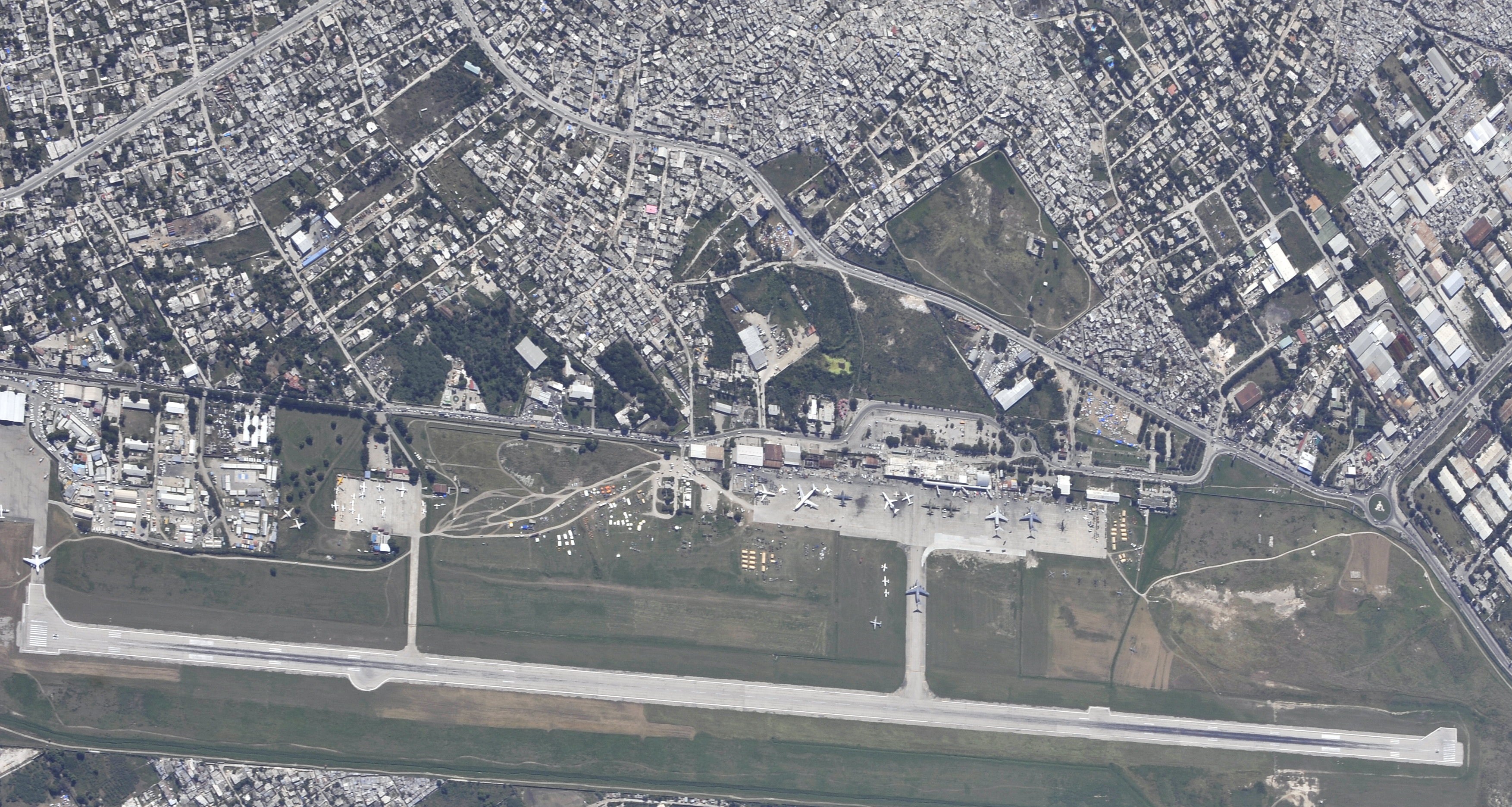
The airport in relation to the city Toussaint Louverture International Airport (IATA: PAP, ICAO: MTPP) is an airport located in Port-au-Prince, Haiti, serving as main international gateway of the country. As of January 2010 it was temporarily placed under the control of the United States Air Force, due to major international relief efforts following the Haiti earthquake. It is currently one of 2 operational airports near the epicentre of the earthquake, the other being Jacmel Airport, formally under the control of the Canadian Forces. History
In the 1940s a military and civil airfield, Bowen Field, was established near Baie de Port-au-Prince providing passenger air service by Compagnie Haitienne de Transports Aériens. It served as an airbase for the U.S. military in Haiti in the 1950s and 1960s.
Developed with grant money from the United States Government, the current airport opened in 1965 as Francois Duvalier International Airport, named after then Haitian president Francois "Papa Doc" Duvalier. Following the resignation of Duvalier's son and successor Jean Claude Duvalier in 1986, the airport was renamed Port-au-Prince International, before being renamed again as Toussaint Louverture International Airport in 2003, in honour of the Haitian revolutionary leader.
Facilities
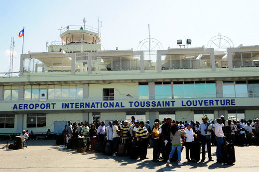
The main building of the airport works as the International Terminal. It consists of a two story concrete and glass structure. Lounges and a few retail stores are located on the second floor of the main building. Check-in counters, gates and immigration facilities are on the lower floor. The Guy Malary Terminal (named after former Haitian Justice Minister Guy Malary) is used for domestic flights. There are further buildings used for general aviation and cargo flights. The airport has 3 jet bridges, but most passengers walk onto aircraft from mobile stairs. The ramp area can handle 12 planes.
Access
The airport can be accessed by car (with parking space being located adjacent to the terminal building) or by National Bus Route 1.
Airlines and destinations
| Airlines |
Destinations |
| Air Caraïbes |
Cayenne, Fort-de-France, Paris-Orly, Pointe-à-Pitre, Santo Domingo, St Maarten |
| Air Canada |
Montréal-Trudeau |
| Air France |
Fort-de-France, Miami, Pointe-à-Pitre |
| Air Transat |
Montréal-Trudeau |
| American Airlines |
Fort Lauderdale, Miami, New York-JFK |
| American Eagle |
San Juan, Santiago de los Caballeros [seasonal], Santo Domingo |
| Caribintair |
Nassau, Santiago de los Caballeros, Jacmel, Jérémie, Les Cayes |
| Continental Airlines |
Newark |
| Copa Airlines |
Panama City |
| Corsairfly |
Paris-Orly |
| Delta Air Lines |
New York-JFK |
| Insel Air |
Curaçao, Miami, St Maarten |
| Pan Am World Airways Dominicana |
Santo Domingo |
| Spirit Airlines |
Fort Lauderdale |
| Sunwing Airlines |
Montreal-Trudeau |
| Tortug' Air |
Jacmel, Jérémie, Les Cayes, Port-de-Paix |
Cargo airlines
- ABX Air (Miami)
- Amerijet International (Miami, Santiago, Santo Domingo)
- IBC Airways (Miami)
2010 Haitian earthquake
 | |
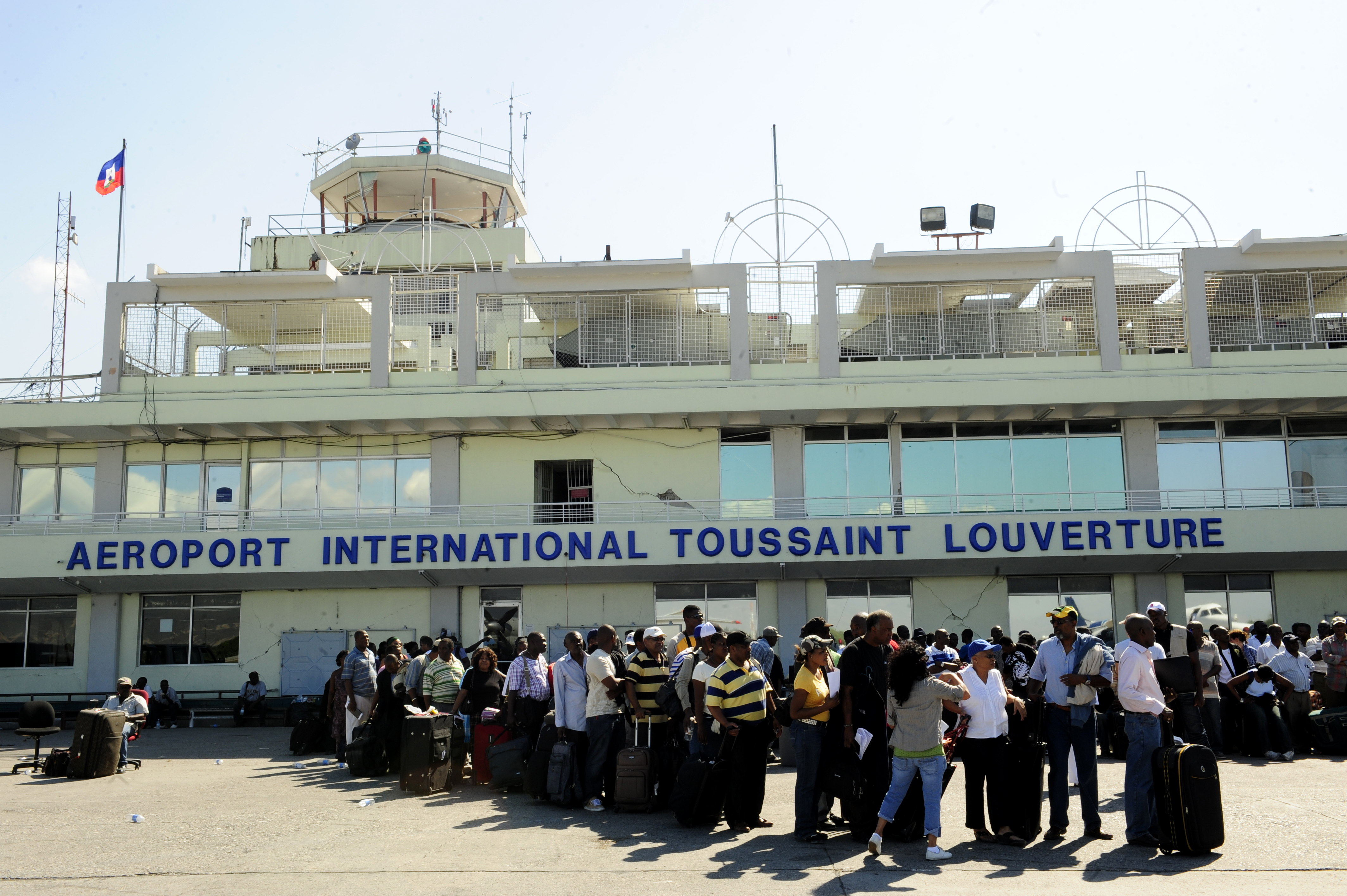
People awaiting evacuation at the airport, January 15. |
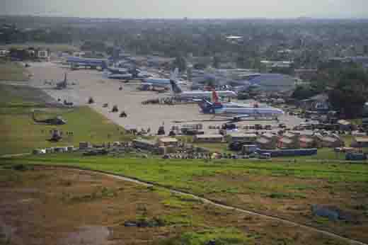 | |
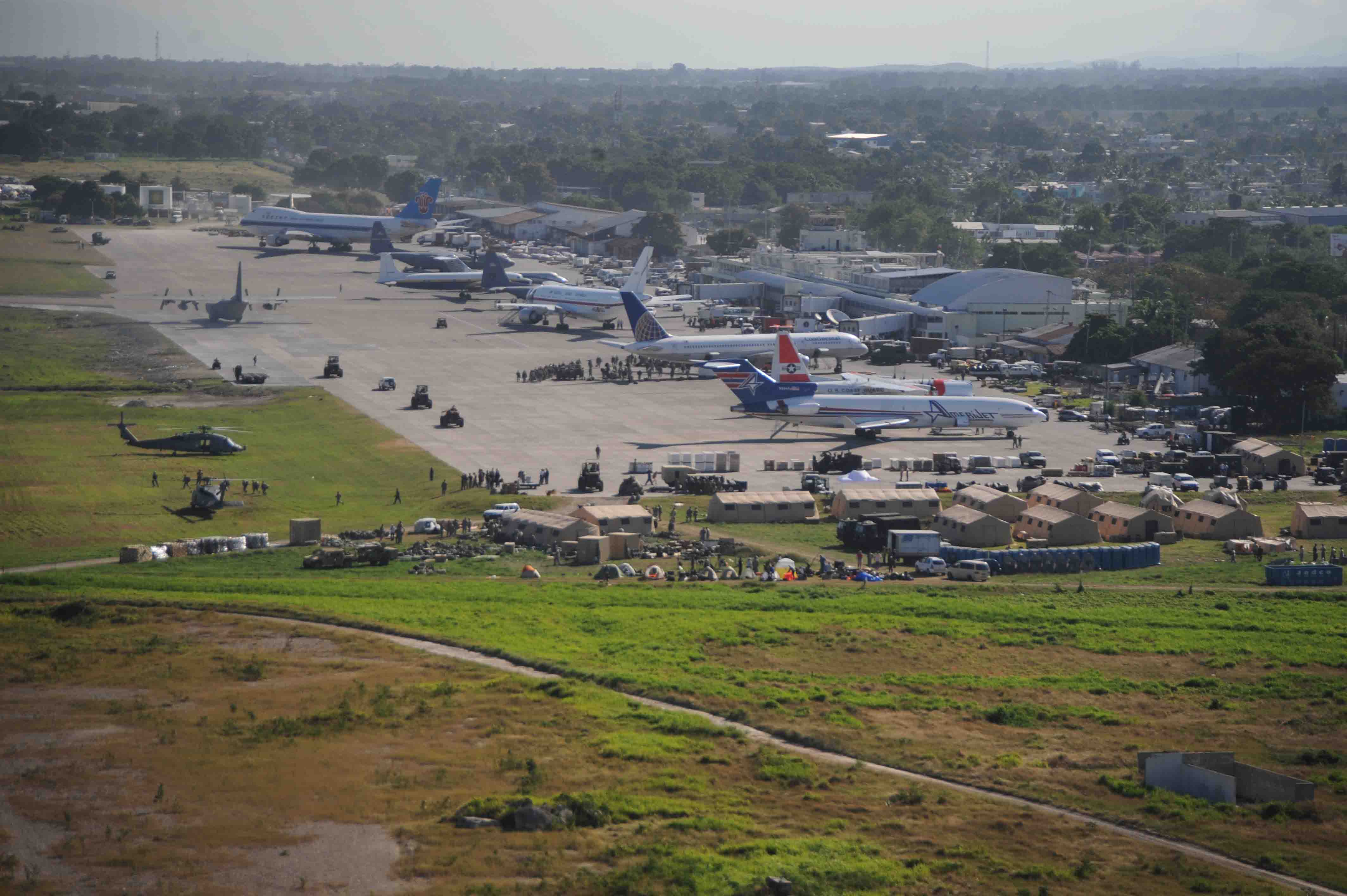
Relief operations crowd the tarmac, January 18. |
Due to the close proximity and shallow depth (6 miles) to the hypocenter or focus of the 2010 Haitian earthquake on January 12, Toussaint Louverture International Airport was damaged. While the runway, the taxiways and the apron of the airport remained operational, radio communications were not possible due to the control tower suffering extensive damage. The airport lighting system was also shut down due to power outages. Nevertheless, the airport was able to be accessed with UNICOM procedures after the quake.
On the morning of January 13, the U.S. Coast Guard cutter Forward arrived and began running air-traffic control from Port-au-Prince Bay. UN Peacekeeping forces had also moved quickly to secure the airport, thus allowing international rescue and aid forces to start their work. Later in the day, United States Air Force Special Tactics personnel landed at the airport and assumed air traffic control (ATC) duties as well as much of the operation of the airport. Their ATC set-up consisted of a folding table placed near the runway and handheld transceivers, as well as the use of a motorcycle to guide aircraft to parking zones.
As of January 14, dozens of cargo planes were landing and taking off, but regular scheduled commercial air service ceased. Meantime, some inbound travelers were reaching Haiti by flying to neighboring Dominican Republic, primarily Las Américas International Airport in Santo Domingo, and then traveling overland.
On January 15, heavy traffic to the airport forced the Federal Aviation Administration's Air Traffic Control System Command Center to issue a ground stop for all aircraft attempting to leave the U.S. for Haitian airspace due to limited space and lack of fuel at the airport. Problems had been compounded by pilots inbound to the airport canceling instrument flight rules operation and proceeding on visual flight rules. That day the United States was formally granted temporary control of the airport per a memorandum of understanding signed by the Haitian Prime Minister. The airport has apparently been operating without radar, although the aircraft carrier USS Carl Vinson arrived the morning of the 15th and has advanced aircraft tracking capabilities.
By the morning of January 18, less than five days after arriving, a reported 819 aircraft had landed under the direction of the USAF team. That day, 180 flights were handled at the airport according to Lieutenant General Ken Keen, commander of the U.S. joint task force assisting in Haiti.
Late in January, US military had plans established to reopen the airport to civilian flights. Some military flights would be shifted to Jacmel Airport, under control of the Canadian Forces.
On February 19, 2010, partial commercial operation returned to the airport.
Incidents and accidents
- March 7, 1980: A Learjet (N211MB) operating on a corporate charter flight on behalf of 'Merchant Bank' crashed in the hills on arrival at airport. One passenger and two crew members died.
- 12 July 1980: A Douglas C-47 crashed on approach, killing all three people on board. The aircraft was being used illegally to transport marijuana.
- December 7, 1995: An Air St. Martin Beechcraft 1900D aircraft (F-OHRK) hit a mountain at an altitude of 5,030 feet (1,533 m), 30 kilometres (19 mi) away from airport. Two crew members and 18 passengers (which were illegal immigrants to Guadeloupe) were killed.
- February 12, 1996: A Haiti Express GAF Nomad aircraft (N224E) crashed shortly after taking off. Two crew members and 8 passengers died.
- August 31, 2007: A Caribintair Cessna Grand Caravan (HH-CAR) crashed shortly after takeoff 5 kilometres (3 mi) away from the airport. There were no fatal injuries.
- September 11, 2007: Only eleven days after the previous accident another plane crash of a Caribintair Cessna Grand Caravan (HH-CAW) occurred near the airport, this time upon landing 10 kilometres (6 mi) short of the runway.
The above content comes from Wikipedia and is published under free licenses – click here to read more.
| General Info
|
| Country |
Haiti
|
| ICAO ID |
MTPP
|
| Time |
UTC-5
|
| Latitude |
18.580050
18° 34' 48.18" N
|
| Longitude |
-72.292542
072° 17' 33.15" W
|
| Elevation |
122 feet
37 meters
|
| Type |
Civil
|
| Magnetic Variation |
009° W (01/06)
|
| Beacon |
Yes
|
| Operating Agency |
CIVIL GOVERNMENT, (LANDING FEES AND DIPLOMATIC CLEARANCE MAY BE REQUIRED)
|
| Alternate Name |
PORT AU PRINCE INTL
|
| Operating Hours |
SEE REMARKS FOR OPERATING HOURS OR COMMUNICATIONS FOR POSSIBLE HOURS
|
| International Clearance Status |
Airport of Entry
|
| Communications
|
| TWR |
118.3
|
| APP |
119.8
|
| Runways
|
| ID |
Dimensions |
Surface |
PCN |
ILS
|
| 10/28 |
9974 x 141 feet
3040 x 43 meters |
ASPHALT |
- |
YES
|
| Navaids
|
| Type |
ID |
Name |
Channel |
Freq |
Distance From Field |
Bearing From Navaid
|
| VOR-DME |
PAP |
PORT AU PRINCE |
100X |
115.3 |
At Field |
-
|
| NDB |
HHP |
PORT AU PRINCE |
- |
270 |
At Field |
-
|
| Supplies/Equipment
|
| Fuel |
Jet A1, without icing nhibitor.
100/130 MIL Spec, low lead, aviation gasoline (BLUE)
|
| Remarks
|
| CAUTION |
All pilots are req not to increase thrust when backing out or when tail is pointing towards the trml.
|
| CSTMS/AG/IMG |
CSTMS/IMG avbl dly 1100-0300Z.
|
| FUEL |
A1 (Avbl 1130-0100Z Chevron USA Inc, Texaco Haiti Inc, C509-250-1203/4/5, Afterhr fee $50/hr, min $200 Adv ntc rqr. C509-558-0423),Avbl 1100-0300Z (NC-100LL)
|
| OPR HOURS |
Opr 1100-0300Z. OT O/R.
|
The content above was published at Airports-Worldwide.com in 2020.
We don't guarantee the information is fresh and accurate. The data may be wrong or outdated.
For more up-to-date information please refer to other sources.
|
|