 |
|
La Libertad Airport (ICAO: MGLL) is an airport serving the town of La Libertad in Petén Department, Guatemala.
It is 4 kilometres (2.5 mi) southwest of the town.
The Tikal VOR-DME (Ident: TIK) is located 18.2 nautical miles (33.7 km) northeast of the airport.
|
La Libertad Airport |
|
|
| Summary |
| Airport type |
Public |
| Serves |
La Libertad, Guatemala |
| Elevation AMSL |
607 ft / 185 m |
| Coordinates |
16°45′00″N
90°08′25″W |
| Map |
|
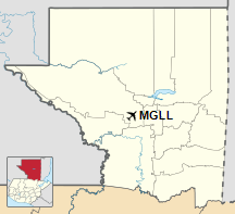
Location in Petén Department
|
| Runways |
| Direction |
Length |
Surface |
| m |
ft |
| 04/22 |
1,170 |
3,839 |
Asphalt |
|
|
Source: Google Maps GCM |
The above content comes from Wikipedia and is published under free licenses – click here to read more.
The content above was published at Airports-Worldwide.com in 2020.
We don't guarantee the information is fresh and accurate. The data may be wrong or outdated.
For more up-to-date information please refer to other sources.
|
|


