|
Muanda Airport or Moanda Airport (IATA: MNB, ICAO: FZAG) is an airport
serving Muanda (also spelled Moanda), an Atlantic coastal city in the Democratic Republic of the Congo.
|
Muanda Airport |
|
|
| Summary |
| Airport type |
Public |
| Operator |
Government |
| Serves |
Muanda (Moanda), Democratic Republic of the Congo |
| Elevation AMSL |
89 ft / 27 m |
| Coordinates |
5°55′51″S
12°21′06″E |
| Map |
|
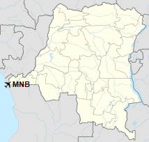
Location within DRC
|
| Runways |
| Direction |
Length |
Surface |
| m |
ft |
| 04/22 |
1,483 |
4,865 |
Asphalt |
|
|
Sources: WAD GCM Google Maps |
Facilities
The airport operates at an elevation of 89 feet (27 m) above mean sea level.
It has one runway designated 04/22 with an asphalt surface measuring 1,483 by 30 metres
(4,865 ft × 98 ft).
The runway is within the city, and begins 600 metres (2,000 ft) inland from the coast. Southwest approach and departure are over the water.
The Kitona Base VOR (Ident: KIT) is located 4.0 nautical miles (7.4 km) east of the airport.
Airlines and destinations
| Airlines |
Destinations |
| Air Tropiques |
Kinshasa–N'Dolo |
| Congo Airways |
Kinshasa–N'Djili |
The above content comes from Wikipedia and is published under free licenses – click here to read more.
The content above was published at Airports-Worldwide.com in 2019.
We don't guarantee the information is fresh and accurate. The data may be wrong or outdated.
For more up-to-date information please refer to other sources.
|


