 |
|
Mokaria-Yamoleka Airport (ICAO: FZFH) is an airstrip serving Mokaria-Yamoleka, a village in the Orientale Province of the Democratic Republic of the Congo. The airstrip is along the road south of the village.
|
Mokaria-Yamoleka Airport |
|
|
| Summary |
| Airport type |
Public |
| Serves |
Mokaria-Yamoleka, Democratic Republic of the Congo |
| Elevation AMSL |
1,378 ft / 420 m |
| Coordinates |
2°05′50″N
23°14′35″E |
| Map |
|
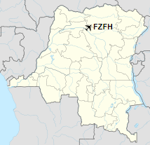
Location of the airport in Democratic Republic of the Congo
|
| Runways |
| Direction |
Length |
Surface |
| m |
ft |
| 18/36 |
1,380 |
4,528 |
Grass |
|
|
Sources: GCM Bing Maps |
The above content comes from Wikipedia and is published under free licenses – click here to read more.
The content above was published at Airports-Worldwide.com in 2019.
We don't guarantee the information is fresh and accurate. The data may be wrong or outdated.
For more up-to-date information please refer to other sources.
|
|


