 |
 |
|
||||
|
City: Sindal, Denmark ICAO / IATA: EKSN / CNL Details Type: Airport Latitude: 57�30'13"N (57.503525) Longitude: 10�13'46"E (10.229372) Elevation: 92 ft (28 m) Timezone: UTC+1 (DST+2) Runways: 1 Longest: 3934 x 98 ft (1199 x 30 m) Weather METAR: EKSN 041350Z 21016KT CAVOK 19/03 Q1015 WWW: Sindal Airport Images and information placed above are from http://gc.kls2.com/airport/EKSN We thank them for the data!
Runway 09/273934 x 98 feet
|
||||||||||||||||||||||||||||||||||||||||||||||||||||||||||||||||||||||||||||||||||||||||||||||||||||||||||||||||||||||||||||||||||
| Runway 09 | |
|---|---|
| Surface | ASPHALT |
| True Heading | 086.0 |
| Latitude | 57.503175 57° 30' 11.43" N |
| Longitude | 10.219392 010° 13' 09.81" E |
| Elevation | 91.0 feet 28 meters |
| Landing Distance | 3934 feet 1199 meters |
| Takeoff Distance | 3934 feet 1199 meters |
| Lighting System | HIRL
M |
| Runway 27 | |
|---|---|
| Surface | ASPHALT |
| True Heading | 266.0 |
| Latitude | 57.503875 57° 30' 13.95" N |
| Longitude | 10.239350 010° 14' 21.66" E |
| Elevation | 92.0 feet 28 meters |
| Landing Distance | 3934 feet 1199 meters |
| Takeoff Distance | 3934 feet 1199 meters |
| Lighting System | HIRL
T |
The content above was published at Airports-Worldwide.com in 2005.
We don't guarantee the information is fresh and accurate. The data may be wrong or outdated.
For more up-to-date information please refer to other sources.

 |
|
Copyright 2004-2026 © by Airports-Worldwide.com, Vyshenskoho st. 36, Lviv 79010, Ukraine Legal Disclaimer |
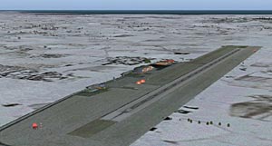 Sindal Airport is a small Domestic airport near Skagen, the most northern point in Denmark. The airfield connects the northern part of Jutland to the rest of Denmark. The airport offers Terminal Hangar and Refuelling facilities, and the Runway 27 has ILS/DME facilities, making it operational in nearly all weather conditions.