 |
 |
|
||||
|
Numerous regular flights on a daily basis to Copenhagen are operated by Cimber Air. Also, Bornholm Airport is an international gateway fulfilling all requirements linked to this fact. Naturally direct booking and luggage check-in to foreign destinations via Copenhagen Airport is available at the ticket office in our air terminal. Any air trip takes its beginning on the ground. Our task is to provide the ultimate service to our passengers and other guests. Though, being proud of the standard already offered, we are still doing our outmost to make it even better which is our guarantee that any stay at Bornholm Airport is sure to give you a pleasant time and a memorable experience Bornholm-Roenne Airport (RNN / EKRN)Airport Code : RNN Airport name : Ronne Airport Runway Length : 6562 ft. Runway Elevation : 52 ft. City : Bornholm Country : Denmark Country Abbrev. : DK World Area Code : 419 GMT Offset : +1.0 Longitude : 14� 45' 0" E Latitude : 55� 4' 0" N Operator: CAA Airport Data: Roenne 5km (3miles), Operating hours Mon-Fri 7:00-22:45, Sat 7:00-19:45, Sun 8:00-22:45 Airfield Data Runway 1: Heading 11/29, 2,000m (6,561ft) Airlines Serving Airport: Maersk Air Bornholm Airport, Denmark, P.O. Box 114, DK-3700 Roenne Tel: +45 56 95 26 26 Fax: +45 56 95 22 54 E-mail: askn at slv dk E-mail: stje at slv dk Images and information placed above are from http://www.world-airport-codes.com/denmark/ronne-airport-6372.html, http://www.azworldairports.com/ We thank them for the data!
Runway 11/296568 x 148 feet
|
||||||||||||||||||||||||||||||||||||||||||||||||||||||||||||||||||||||||||||||||||||||||||||||||||||||||||||||||||||||||||||||||||||||||||||||||||||||||||||||||||||||||||||||||||||||||||||||||||||||
| Runway 11 | |
|---|---|
| Surface | ASPHALT |
| True Heading | 114.0 |
| Latitude | 55.066883 55° 04' 00.78" N |
| Longitude | 14.745214 014° 44' 42.77" E |
| Elevation | 46.0 feet 14 meters |
| Slope | 0.1° |
| Landing Distance | 6568 feet 2002 meters |
| Takeoff Distance | 6568 feet 2002 meters |
| Lighting System | HIRL
A1 PAPI |
| Runway 29 | |
|---|---|
| Surface | ASPHALT |
| True Heading | 294.0 |
| Latitude | 55.059647 55° 03' 34.73" N |
| Longitude | 14.773903 014° 46' 26.05" E |
| Elevation | 51.0 feet 16 meters |
| Slope | -0.1° |
| Landing Distance | 6568 feet 2002 meters |
| Takeoff Distance | 6765 feet 2062 meters |
| Overrun Length | 197 feet 60 meters |
| Overrun Surface | ASPHALT |
| Lighting System | HIRL
A1 PAPI |
| RONNE | |||||
|---|---|---|---|---|---|
| Type | ID | Channel | Freq | Country | State |
| VORTAC | ROE | 057X | 112 | Denmark | - |
| Latitude | Longitude | Airport |
| 55.065578 55° 03' 56.08" N |
14.758692 014° 45' 31.29" E |
EKRN |
The content above was published at Airports-Worldwide.com in 2005.
We don't guarantee the information is fresh and accurate. The data may be wrong or outdated.
For more up-to-date information please refer to other sources.

 |
|
Copyright 2004-2026 © by Airports-Worldwide.com, Vyshenskoho st. 36, Lviv 79010, Ukraine Legal Disclaimer |
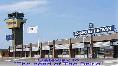 Bornholm Airport may not be one of the largest airports in Denmark � but it is propably situated in the most beautiful place! Being the evident approach to the lovely island of Bornholm in the middle of the Baltic we offer a friendly and personal service, forming a modern airport large enough to serve nearly any type of aircraft.