 |
 |
|
||||
|
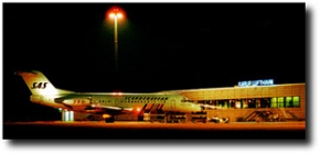
Karup Airport is the biggest airport in Viborg County and it has daily departures to Copenhagen and international destinations. History In the 1960, the idea of establishing an airport for the middle- and western part of Jutland flourished. The concept of providing the sourrounding area with a route connection to Copenhagen. Allready there were airports in the cities Tirstrup, Billund and Aalborg, who offered regular flights and they were, and still is, an essential part of the area they are each situated in. For a number of years, it was the idea that the new Danish airport should be situated at �Tiphede� some km. from Karup Airport. But soon; the idea of merely using and extending the facilities of Military Air Base Karup came up. This proposal was agreed upon by the Danish government in 1965 and a temporary opening for civil air service was follow through in the Military Air Bases in Karup and Skrydstrup (at Seeland). The flight-route opened at the 1st of November 1965. In Karup it was allowed to make 2 double flights in SAS-management a day and this was done with a 15-person Heron-aeroplane. The first year 17.000 passengers flew from Karup. The following year, a 56-person Metropolitan-aeroplane replaced the Heron. Also in 1966, a co-operative society was created by the 2 county counsil districts and 9 municipalities so that the running of the flight route could be managed properly. Participating was: Ringkj�bing and Viborg county counsil districts, Lemvig, Ringkj�bing, Skjern, Struer, Herning, Holstebro, Ikast, Skive and Viborg muncipality. The economical foundation was first and foremost the funds of the co-operative society; 913.525 DKR. This is the first and only time any tax-money has been used on Karup airport. Since then, the airport has been self sufficient, meaning that Karup Airport today is totally user � financed; we do not receive any grants toward running costs from county councils, muncipalities or other. At the beginning, facilities were a lot more primitive than they are today. In 1967 the terminal that was used all the way up to 1991 was opened. The expenses on building this was about 1.5 mill. DKR.
In 1996, Karup Airport extended the terminal with a new gate, that serves as an foerign-travels facility. Here the tax-free shop I situated. Also passport- and customs have been established, so that the airport today has the status of being an international airport (ICAP and Schengen-status) This extention of the airport cost app. 8 mill. DKR. And finally in 1997, the airplane pitch was made bigger � from 12.000 to 25.000 m2 � costing around 11. mill DKR. All in all, Karup Lufthavn has invested right about 125 mill. DKR. Just the terminal itself is financed by loans; the rest has Karup Airport provided from its own capital. Phone: (+45) 97 10 06 10 Fax: (+45) 97 10 06 65 Aftn adresse: EKKAYOYP Sita adresse: KRPKOQI (via Cimber Air) Email: mail at karup-airport dk Email: webmaster at karup-airport dk WWW: Karup Airport Images and information placed above are from http://www.vibamt.dk/ea/rifo/facts/infrastr.htm, We thank them for the data!
Runway 04/222936 x 50 feet
|
||||||||||||||||||||||||||||||||||||||||||||||||||||||||||||||||||||||||||||||||||||||||||||||||||||||||||||||||||||||||||||||||||||||||||||||||||||||||||||||||||||||||||||||||||||||||||||||||||||||||||||||||||||||||||||||||||||||||||||||||||||||||||||||||||||||||||||||||||||||||||||||||||||||||||||||||||||||||||||||||||||||||||||||||||||||||||||||||||||||||||||||||||||||||||||||||||||||||||||||||||||||||||||||||||||||
| Runway 04 | |
|---|---|
| Surface | PART CONCRETE, PART ASPHALT, OR PART BITUMEN-BOUND MACADAM. |
| True Heading | 034.0 |
| Latitude | 56.297500 56° 17' 51.00" N |
| Longitude | 9.104722 009° 06' 17.00" E |
| Elevation | 164.0 feet 50 meters |
| Slope | 0.0° |
| Landing Distance | 2936 feet 895 meters |
| Takeoff Distance | 2936 feet 895 meters |
| Lighting System | LIRL |
| Runway 22 | |
|---|---|
| Surface | PART CONCRETE, PART ASPHALT, OR PART BITUMEN-BOUND MACADAM. |
| True Heading | 214.0 |
| Latitude | 56.304444 56° 18' 16.00" N |
| Longitude | 9.113056 009° 06' 47.00" E |
| Elevation | 163.0 feet 50 meters |
| Slope | 0.0° |
| Landing Distance | 2936 feet 895 meters |
| Takeoff Distance | 2936 feet 895 meters |
| Lighting System | LIRL |
| Runway 09 | |
|---|---|
| Surface | GRASS OR EARTH NOT GRADED OR ROLLED. |
| True Heading | 090.0 |
| Latitude | 0.000000 - |
| Longitude | 0.000000 - |
| Landing Distance | 2789 feet 850 meters |
| Takeoff Distance | 2789 feet 850 meters |
| Runway 27 | |
|---|---|
| Surface | GRASS OR EARTH NOT GRADED OR ROLLED. |
| True Heading | 270.0 |
| Latitude | 0.000000 - |
| Longitude | 0.000000 - |
| Landing Distance | 2789 feet 850 meters |
| Takeoff Distance | 2789 feet 850 meters |
| Runway 09R | |
|---|---|
| Surface | PART CONCRETE, PART ASPHALT, OR PART BITUMEN-BOUND MACADAM. |
| True Heading | 089.0 |
| Latitude | 56.297150 56° 17' 49.74" N |
| Longitude | 9.077331 009° 04' 38.39" E |
| Elevation | 154.0 feet 47 meters |
| Slope | 0.2° |
| Landing Distance | 9607 feet 2928 meters |
| Takeoff Distance | 10352 feet 3155 meters |
| Overrun Length | 745 feet 227 meters |
| Overrun Surface | ASPHALT |
| Lighting System | CL
HIRL BP PAPI |
| Runway 27L | |
|---|---|
| Surface | PART CONCRETE, PART ASPHALT, OR PART BITUMEN-BOUND MACADAM. |
| True Heading | 269.0 |
| Latitude | 56.297458 56° 17' 50.85" N |
| Longitude | 9.124628 009° 07' 28.66" E |
| Elevation | 170.0 feet 52 meters |
| Slope | -0.2° |
| Landing Distance | 9607 feet 2928 meters |
| Takeoff Distance | 10362 feet 3158 meters |
| Overrun Length | 755 feet 230 meters |
| Overrun Surface | ASPHALT |
| Lighting System | TDZL
CL HIRL J PAPI |
| Runway 09L | |
|---|---|
| Surface | ASPHALT |
| True Heading | 089.0 |
| Latitude | 56.299083 56° 17' 56.70" N |
| Longitude | 9.077622 009° 04' 39.44" E |
| Elevation | 154.0 feet 47 meters |
| Slope | 0.2° |
| Landing Distance | 9816 feet 2992 meters |
| Takeoff Distance | 10282 feet 3134 meters |
| Overrun Length | 466 feet 142 meters |
| Overrun Surface | ASPHALT |
| Lighting System | LIRL
PAPI |
| Runway 27R | |
|---|---|
| Surface | ASPHALT |
| True Heading | 269.0 |
| Latitude | 56.299400 56° 17' 57.84" N |
| Longitude | 9.125953 009° 07' 33.43" E |
| Elevation | 170.0 feet 52 meters |
| Slope | -0.2° |
| Landing Distance | 9816 feet 2992 meters |
| Takeoff Distance | 10389 feet 3167 meters |
| Overrun Length | 573 feet 175 meters |
| Overrun Surface | ASPHALT |
| Lighting System | LIRL
PAPI |
| Runway 14 | |
|---|---|
| Surface | PART CONCRETE, PART ASPHALT, OR PART BITUMEN-BOUND MACADAM. |
| True Heading | 134.0 |
| Latitude | 56.302778 56° 18' 10.00" N |
| Longitude | 9.112778 009° 06' 46.00" E |
| Elevation | 163.0 feet 50 meters |
| Slope | 0.1° |
| Landing Distance | 2296 feet 700 meters |
| Takeoff Distance | 2296 feet 700 meters |
| Lighting System | LIRL |
| Runway 32 | |
|---|---|
| Surface | PART CONCRETE, PART ASPHALT, OR PART BITUMEN-BOUND MACADAM. |
| True Heading | 314.0 |
| Latitude | 56.298333 56° 17' 54.00" N |
| Longitude | 9.120833 009° 07' 15.00" E |
| Elevation | 166.0 feet 51 meters |
| Slope | -0.1° |
| Landing Distance | 2296 feet 700 meters |
| Takeoff Distance | 2296 feet 700 meters |
| Lighting System | LIRL |
| KARUP | |||||
|---|---|---|---|---|---|
| Type | ID | Channel | Freq | Country | State |
| TACAN | KAR | 037X | - | Denmark | - |
| Latitude | Longitude | Airport |
| 56.296675 56° 17' 48.03" N |
9.008597 009° 00' 30.95" E |
EKKA |
| KARUP | |||||
|---|---|---|---|---|---|
| Type | ID | Channel | Freq | Country | State |
| NDB | KA | - | 369 | Denmark | - |
| Latitude | Longitude | Airport |
| 56.298450 56° 17' 54.42" N |
9.236958 009° 14' 13.05" E |
EKKA |
The content above was published at Airports-Worldwide.com in 2005.
We don't guarantee the information is fresh and accurate. The data may be wrong or outdated.
For more up-to-date information please refer to other sources.

 |
|
Copyright 2004-2026 © by Airports-Worldwide.com, Vyshenskoho st. 36, Lviv 79010, Ukraine Legal Disclaimer |
 From that day and onwards, things have been almost straight ahead. Up through the 1970ies and 1980ies investments were carried out concerning technical landing equipment and reinforcement of the lanes � which was necessary since the planes that was being used became bigger and heavier. Besides the pitch for the airplanes and establishment of a big parking area. In 1991 a brand new terminal was opened. To build it, the airport needed approximately 50 mill. DKR. In 1994, a ILS-category II landing facility was build. This meant that the aeroplanes had a far better chance of holding schedule in departure and arrival when having to deal with unclear and foggy weather. This was an investment for about 20 mio. DKR and was also paid entirely by Karup Airport.