 |
 |
|
||||
|
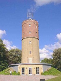
Aars is a municipality in northern Denmark, in the county of North Jutland on the peninsula of Jutland. The municipality covers an area of 223 km2, and has a total population of 13,172. Aars means an oasis, and on walks around the town you will encounter many unforgettable things. Among other things you will see art of international format, and you will sens the intense atmosphere of the local shopping street, which was recently renovated. Service is a keyword here in Aars, and all year round there is a swirl of activities to suit all ages. As a contrast to the modern shopping centre of Aars other parts of the council offer unique nature and rustic village life. E-mail: raadhuset at aarskommune dk WWW: Aars Kommune Images and information placed above are from Aars Kommune We thank them for the data!
Runway 11/293976 x 75 feet
|
|||||||||||||||||||||||||||||||||||||||||||||||||||||||||||||||||||||||||||||||||||||||||||||||||||||||||||||||||||||||||||||||||||||||||||||||||||||||||||||||||||||||||||||
| Runway 11 | |
|---|---|
| Surface | ASPHALT |
| True Heading | 107.0 |
| Latitude | 56.848483 56° 50' 54.54" N |
| Longitude | 9.449264 009° 26' 57.35" E |
| Elevation | 119.0 feet 36 meters |
| Slope | -0.4° |
| Landing Distance | 3484 feet 1062 meters |
| Takeoff Distance | 3976 feet 1212 meters |
| Displaced Threshold Length | 492 feet 150 meters |
| Lighting System | PCL
LIGHTS |
| Runway 29 | |
|---|---|
| Surface | ASPHALT |
| True Heading | 287.0 |
| Latitude | 56.845325 56° 50' 43.17" N |
| Longitude | 9.467958 009° 28' 04.65" E |
| Elevation | 103.0 feet 31 meters |
| Slope | 0.4° |
| Landing Distance | 3484 feet 1062 meters |
| Takeoff Distance | 3976 feet 1212 meters |
| Displaced Threshold Length | 492 feet 150 meters |
| Lighting System | PCL
LIGHTS |
| Runway 17 | |
|---|---|
| Surface | GRADED OR ROLLED EARTH, GRASS ON GRADED EARTH. |
| True Heading | 174.5 |
| Latitude | 56.846111 56° 50' 46.00" N |
| Longitude | 9.460833 009° 27' 39.00" E |
| Landing Distance | 1804 feet 550 meters |
| Takeoff Distance | 1804 feet 550 meters |
| Runway 35 | |
|---|---|
| Surface | GRADED OR ROLLED EARTH, GRASS ON GRADED EARTH. |
| True Heading | 354.5 |
| Latitude | 56.841389 56° 50' 29.00" N |
| Longitude | 9.461667 009° 27' 42.00" E |
| Landing Distance | 1804 feet 550 meters |
| Takeoff Distance | 1804 feet 550 meters |
The content above was published at Airports-Worldwide.com in 2005.
We don't guarantee the information is fresh and accurate. The data may be wrong or outdated.
For more up-to-date information please refer to other sources.

 |
|
Copyright 2004-2026 © by Airports-Worldwide.com, Vyshenskoho st. 36, Lviv 79010, Ukraine Legal Disclaimer |
 About Aars