 |
|
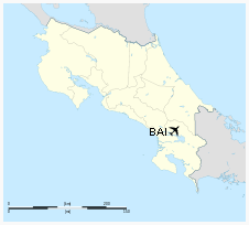
| Buenos Aires Airport |
IATA : BAI – ICAO : MRBA
|
| Summary |
| Airport type |
Public |
| Serves |
Buenos Aires, Costa Rica |
| Elevation AMSL |
1,214 ft / 370 m |
| Coordinates |
9°9′49″N
83°19′48″W / -34.82222; -58.53583 (Ministro Pistarini International Airport) |
| Runways |
| Direction |
Length |
Surface |
| m |
ft |
| 01/19 |
3,248 |
990 |
Concrete |
| Sources:
World Aero Data |
The above content comes from Wikipedia and is published under free licenses – click here to read more.
| General Info
|
| Country |
Costa Rica
|
| ICAO ID |
MRBA
|
| Time |
UTC-6
|
| Latitude |
9.163606
09° 09' 48.98" N
|
| Longitude |
-83.329872
083° 19' 47.54" W
|
| Elevation |
1214 feet
370 meters
|
| Magnetic Variation |
000° W (01/06)
|
| Operating Agency |
CIVIL GOVERNMENT, (LANDING FEES AND DIPLOMATIC CLEARANCE MAY BE REQUIRED)
|
| Operating Hours |
SUNRISE TO SUNSET (SR-SS)
|
| Communications
|
| COCO RDO |
126.8
|
| Runways
|
| ID |
Dimensions |
Surface |
PCN |
ILS
|
| 01/19 |
3248 x 33 feet
990 x 10 meters |
CONCRETE. |
- |
NO
|
| Remarks
|
| CAUTION |
People and vehicles ocnl crossing rwy.
|
| OPR HOURS |
Opr SR-SS.
|
The content above was published at Airports-Worldwide.com in 2020.
We don't guarantee the information is fresh and accurate. The data may be wrong or outdated.
For more up-to-date information please refer to other sources.
|
|


