 |
|
| Rarotonga International Airport |
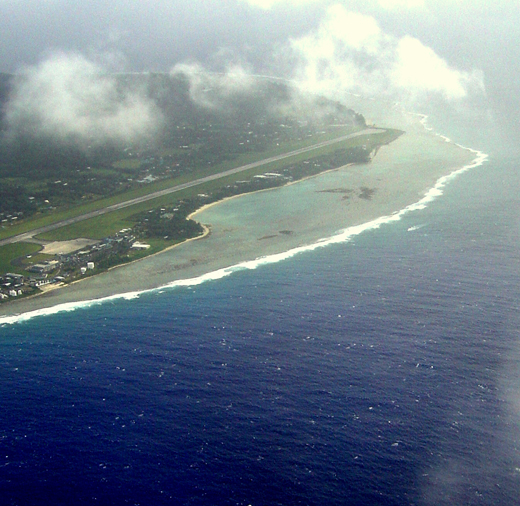 |
| Rarotonga International Airport from the air |
| IATA: RAR – ICAO: NCRG |
| Summary |
| Airport type |
Public |
| Serves |
Avarua |
| Location |
Avarua, Rarotonga, Cook Islands |
| Elevation AMSL |
19 ft / 6 m |
| Coordinates |
21°12′10″S 159°48′20″W / 21.20278°S 159.80556°W / -21.20278; -159.80556 |
| Runways |
| Direction |
Length |
Surface |
| m |
ft |
| 08/26 |
2,328 |
7,638 |
Concrete |
Rarotonga International Airport (IATA: RAR, ICAO: NCRG) is the Cook Islands' main international gateway, located in the town and district of Avarua, Rarotonga, three kilometers west of the downtown area on the northern coast.
In 2003, $650,000 was spent on revamping the terminal, as well as the departure and check-in areas.[1]
An $8.5m reconstuction project commenced in 2009 to revamp and expand the existing terminal facilities. The new-look terminal was officially opened on 22 June 2010. Airlines and destinations
| Airlines |
Destinations |
| Air New Zealand |
Auckland, Christchurch, Los Angeles, Sydney |
| Air Rarotonga |
Aitutaki, Atiu, Manihiki, Mauke, Mangaia, Mitiaro |
| Air Tahiti |
Papeete |
| Virgin Blue operated by Pacific Blue |
Auckland |
The above content comes from Wikipedia and is published under free licenses – click here to read more.
| General Info
|
| Country |
Cook Islands
|
| ICAO ID |
NCRG
|
| Time |
UTC-10(-9:30DT)
|
| Latitude |
-21.202739
21° 12' 09.86" S
|
| Longitude |
-159.805556
159° 48' 20.00" W
|
| Elevation |
19 feet
6 meters
|
| Type |
Civil
|
| Magnetic Variation |
013° E (01/06)
|
| Beacon |
Yes
|
| Operating Agency |
CIVIL GOVERNMENT, (LANDING FEES AND DIPLOMATIC CLEARANCE MAY BE REQUIRED)
|
| Near City |
Avarua
|
| Island Group |
Cook I
|
| Operating Hours |
SEE REMARKS FOR OPERATING HOURS OR COMMUNICATIONS FOR POSSIBLE HOURS
|
| International Clearance Status |
Airport of Entry
|
| Communications
|
| TWR |
118.1
121.9
|
| RDO |
3425
6553
8846
11339
|
| APP |
118.1
121.9
|
| Runways
|
| ID |
Dimensions |
Surface |
PCN |
ILS
|
| 08/26 |
7638 x 150 feet
2328 x 46 meters |
CONCRETE. |
054RBWT |
YES
|
| Navaids
|
| Type |
ID |
Name |
Channel |
Freq |
Distance From Field |
Bearing From Navaid
|
| VOR-DME |
RG |
RAROTONGA |
082X |
113.5 |
At Field |
-
|
| NDB |
RG |
RAROTONGA |
- |
352 |
1.0 NM |
056.1
|
| Supplies/Equipment
|
| Fuel |
Jet A1, without icing nhibitor.
100/130 MIL Spec, low lead, aviation gasoline (BLUE)
|
| Oil |
Available (Types unknown)
|
| Other Fluids |
Available (Type unknown)
|
| Remarks
|
| CAUTION |
Unlit mast aprx 513' MSL, posn 4134' SSW Rwy 08 thld.
|
| FLUID |
PPR
|
| FUEL |
PPR through DCA Head Office, Wellington; NZHOYA. (NC-100LL, A1)
|
| LGT |
T-VASI Rwy 08 TCH 50'; Rwy 26 TCH 54'.
|
| MISC |
Acft to remain at afld more than 2 hr are req to carry a towbar to assist psn onapn.
|
| OIL |
PPR
|
| OPR HOURS |
Opr HS by NOTAM, OT PPR.
|
The content above was published at Airports-Worldwide.com in 2010.
We don't guarantee the information is fresh and accurate. The data may be wrong or outdated.
For more up-to-date information please refer to other sources.
|
|


