|
Punta el Saco Airport Spanish: Aeropuerto Punta el Saco, (ICAO: SCHM) is an airport on the south shore
of Isla Mocha, a small Pacific island 32 kilometres (20 mi) off the coast of Chile. Isla Mocha is part of Chile's Bío Bío Region.
The airport is in a narrow strip between the rocky shore and the coast road. Approach and departures are mostly over the water. There is a large hill northeast of the runway.
The Araucania VOR-DME (Ident: NIA) is located 66.3 nautical miles (122.8 km) east-southeast of the airport. There are no published radio navaids on the island.
|
Punta el Saco Airport |
|
|
| Summary |
| Airport type |
Public |
| Serves |
Isla Mocha, Chile |
| Elevation AMSL |
23 ft / 7 m |
| Coordinates |
38°24′40″S
73°54′20″W |
| Map |
|
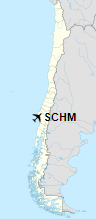
Location of Punta el Saco Airport in Chile
|
| Runways |
| Direction |
Length |
Surface |
| m |
ft |
| 12/30 |
700 |
2,297 |
Grass |
|
|
Source: Landings.com Google Maps GCM |
The above content comes from Wikipedia and is published under free licenses – click here to read more.
The content above was published at Airports-Worldwide.com in 2020.
We don't guarantee the information is fresh and accurate. The data may be wrong or outdated.
For more up-to-date information please refer to other sources.
|


