Hacienda Lipangue Airport |
Hacienda Lipangue Airport Spanish: Aeropuerto de Hacienda Lipangue,
(ICAO: SCHL) is an airstrip 6 kilometres (3.7 mi) southwest of Lampa, a city in the Santiago Metropolitan Region of Chile.
There is mountainous terrain in all quadrants except east.
The Pudahuel VOR-DME (Ident: PDH) is located 7.3 nautical miles (13.5 km) southeast of the airstrip.
|
Hacienda Lipangue Airport |
|
|
| Summary |
| Airport type |
Public |
| Serves |
Lampa, Chile |
| Elevation AMSL |
1,745 ft / 532 m |
| Coordinates |
33°20′10″S
70°54′58″W |
| Map |
|
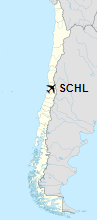
Location of Hacienda Lipangue Airport in Chile
|
| Runways |
| Direction |
Length |
Surface |
| m |
ft |
| 05/23 |
785 |
2,575 |
Dirt |
|
|
Source: GCM Landings.com Google Maps |
The above content comes from Wikipedia and is published under free licenses – click here to read more.
The content above was published at Airports-Worldwide.com in 2020.
We don't guarantee the information is fresh and accurate. The data may be wrong or outdated.
For more up-to-date information please refer to other sources.
|


