 |
|
Gaspé (Michel-Pouliot) Airport |
Michel-Pouliot Gaspé Airport or Gaspé (Michel-Pouliot) Airport, (IATA: YGP, ICAO: CYGP), is located 3.5 nautical miles (6.5 km; 4.0 mi) west of Gaspé, Quebec, Canada. The airport is non-towered, but has a mandatory frequency linked remotely to the flight service station (FSS) located in Mont-Joli. There are instrument approaches available for poor weather.
|
Gaspé (Michel-Pouliot) Airport. |
Both the city and airport are located in a valley that is oriented in a more or less east-west direction, with the eastern end open to the ocean and the western end terminating in the highlands. For this reason, most small (i.e. unpressurized) aircraft prefer to approach from the east, thereby avoiding the steep descent over the high hills to the west.
Michel-Pouliot Gaspé Airport
Gaspé (Michel-Pouliot) Airport |
- IATA: YGP
- ICAO: CYGP
- WMO: 71188
|
| Summary |
| Airport type |
Public |
| Owner/Operator |
Municipality of Gaspé |
| Serves |
Gaspé, Quebec |
| Location |
Gaspé, Quebec |
| Time zone |
EST (UTC−05:00) |
| Summer (DST) |
EDT (UTC−04:00) |
| Elevation AMSL |
112 ft / 34 m |
| Coordinates |
48°46′31″N
064°28′47″W |
| Website |
www.ville.gaspe.qc.ca |
| Map |
|
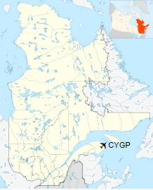
Location in Quebec
|
| Runways |
| Direction |
Length |
Surface |
| ft |
m |
10/28 |
4,487 |
1,368 |
Asphalt |
|
| Statistics (2010) |
| Aircraft movements |
4,506 |
| Number of Passengers |
21,000 (appx.) |
|
|
Source: Canada Flight Supplement
Environment Canada
Movements from Statistics Canada.
Passengers from Town of Gaspe Site. |
History
Transport Canada began construction of the airport in 1965, and handed control to the municipality in 1967 (while continuing to subsidize the airport). The airport added a terminal building in 1972, and a hangar and flight service station in 1974. The hangar was destroyed by a fire in 1978 and rebuilt in 1979; the flight service station has subsequently been closed. In 1983, Transport Canada installed navigation aids (the airport has both a VOR and a LOC), and formally handed full control of the airport over to the municipality in 1998 as a result of the National Airports Policy.
Scheduled Services
| Airlines |
Destinations |
| Air Canada Express |
Îles-de-la-Madeleine, Montréal-Trudeau, Quebec City |
The above content comes from Wikipedia and is published under free licenses – click here to read more.
| General Info
|
| Country |
Canada
|
| ICAO ID |
CYGP
|
| Latitude |
48.775278
48° 46' 31.00" N
|
| Longitude |
-64.478611
064° 28' 43.00" W
|
| Elevation |
108 feet
33 meters
|
| Type |
Civil
|
| Magnetic Variation |
020° W (01/06)
|
| Beacon |
Yes
|
| Operating Agency |
MUNICIPAL
|
| Alternate Name |
HALDIMAND
|
| Daylight Saving Time |
Second Sunday in March at 0200 to first Sunday in November at 0200 local time (Exception Arizona and that portion of Indiana in the Eastern Time Zone)
|
| Communications
|
| MF QUEBEC RDO |
122.3
|
| QUEBEC RDO |
122.3
126.7
|
| Communications Remarks |
|
| RCO |
(RCO)(ARR DEP CON svc)
|
| Runways
|
ID
|
Dimensions |
Surface |
PCN |
ILS
|
| 11/29 |
4500 x 150 feet
1372 x 46 meters |
ASPHALT |
070FCWT |
NO
|
| Navaids
|
| Type |
ID |
Name |
Channel |
Freq |
Distance From Field |
Bearing From Navaid
|
| VOR-DME |
YGP |
GASPE |
101X |
115.4 |
3.0 NM |
305.2
|
| NDB |
GP |
GASPE |
- |
232 |
3.7 NM |
297.7
|
| Supplies/Equipment
|
| Fuel |
Jet A1, without icing nhibitor.
100/130 MIL Spec, low lead, aviation gasoline (BLUE)
|
The content above was published at Airports-Worldwide.com in 2018.
We don't guarantee the information is fresh and accurate. The data may
be wrong or outdated.
For more up-to-date information please refer to other sources.
|
|


 Airport")