|
Tobermory Airport, (TC LID: CNR4), is located 2.2 nautical miles (4.1 km; 2.5 mi) southeast of Tobermory, Ontario, Canada.
| Tobermory Airport |
- IATA: none
- ICAO: none
- TC LID: CNR4
|
| Summary |
| Airport type |
Public |
| Operator |
Township of the North Bruce Peninsula |
| Location |
Tobermory, Ontario |
| Time zone |
EST (UTC−05:00) |
| Summer (DST) |
EDT (UTC−04:00) |
| Elevation AMSL |
700 ft / 213 m |
| Coordinates |
45°13′18″N
081°37′43″W |
| Map |
|
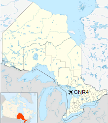
Location in Ontario
|
| Runways |
| Direction |
Length |
Surface |
| ft |
m |
12/30 |
3,180 |
969 |
Asphalt |
|
|
Source: Canada Flight Supplement |
Panorama of taxi area and hangars. The runway is on the left, in the background .
Facilities
The airport has two small hangars to store aircraft (one per hangar), fuel station and a building serving as the airport office.
A small parking lot is found at the entrance along Warner Bay Road.
The above content comes from Wikipedia and is published under free licenses – click here to read more.
| General Info
|
| Country |
Canada
|
| Latitude |
45.233334
45° 14' 00.00" N
|
| Longitude |
-81.633333
081° 38' 00.00" W
|
| Elevation |
700 feet
213 meters
|
| Magnetic Variation |
009° W (01/06)
|
| Beacon |
Yes
|
| Operating Agency |
MUNICIPAL
|
| Daylight Saving Time |
Second Sunday in March at 0200 to first Sunday in November at 0200 local time (Exception Arizona and that portion of Indiana in the Eastern Time Zone)
|
| Communications
|
CTAF/UNICOM
UNICOM opr ltd hr.
|
122.8
|
| Runways
|
ID
|
Dimensions |
Surface |
PCN |
ILS
|
| 12/30 |
3180 x 60 feet
969 x 18 meters |
ASPHALT |
- |
NO
|
| Supplies/Equipment
|
| Fuel |
100/130 MIL Spec, low lead, aviation gasoline (BLUE)
|
The content above was published at Airports-Worldwide.com in 2018.
We don't guarantee the information is fresh and accurate. The data may
be wrong or outdated.
For more up-to-date information please refer to other sources.
|


