 |
|
Pembroke Airport, (IATA: YTA, ICAO: CYTA), is located 5.2 nautical miles (9.6 km; 6.0 mi) northwest of the city of Pembroke, Ontario, Canada.
Pem-Air operated regularly scheduled air service between Pembroke Airport and Toronto for 31 years; ending its scheduled operation in December, 2000.
GO Air Express operated briefly from November 2002 to April 2003 with flights to Toronto.
Since 2003 there is no full-time tenant, but the airport is used by Ministry of Natural Resources (Ontario) water bombers.
| Pembroke Airport |
|
|
| Summary |
| Airport type |
Public |
| Operator |
Pembroke and Area Airport Commission |
| Location |
Pembroke, Ontario, Canada |
| Time zone |
EST (UTC−05:00) |
| Summer (DST) |
EDT (UTC−04:00) |
| Elevation AMSL |
532 ft / 162 m |
| Coordinates |
45°51′52″N
077°15′05″W |
| Map |
|
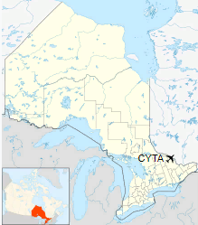
Location in Ontario
|
| Runways |
| Direction |
Length |
Surface |
| ft |
m |
17/35 |
5,000 |
1,524 |
Asphalt |
|
The above content comes from Wikipedia and is published under free licenses – click here to read more.
| General Info
|
| Country |
Canada
|
| ICAO ID |
CYTA
|
| Time |
UTC-5(-4DT)
|
| Latitude |
45.864445
45° 51' 52.00" N
|
| Longitude |
-77.251667
077° 15' 06.00" W
|
| Elevation |
529 feet
161 meters
|
| Type |
Civil
|
| Magnetic Variation |
013° W (01/06)
|
| Beacon |
Yes
|
| Operating Agency |
CIVIL GOVERNMENT, (LANDING FEES AND DIPLOMATIC CLEARANCE MAY BE REQUIRED)
|
| Operating Hours |
SEE REMARKS FOR OPERATING HOURS OR COMMUNICATIONS FOR POSSIBLE HOURS
|
| International Clearance Status |
Airport of Entry
|
| Daylight Saving Time |
Second Sunday in March at 0200 to first Sunday in November at 0200 local time (Exception Arizona and that portion of Indiana in the Eastern Time Zone)
|
| Communications
|
CTAF/UNICOM
UNICOM opr ltd hr.
|
122.8
|
PETAWAWA ADVSY
Opr 1300-2130Z++ Mon-Fri, OT PPR.
|
126.4
250.1
|
| MONTREAL CNTR |
135.2
278.5
|
| Communications Remarks |
|
| A/D |
(APP/DEP svc)
|
| Runways
|
ID
|
Dimensions |
Surface |
PCN |
ILS
|
| 17/35 |
5000 x 100 feet
1524 x 30 meters |
ASPHALT |
028FAYT |
NO
|
| Navaids
|
| Type |
ID |
Name |
Channel |
Freq |
Distance From Field |
Bearing From Navaid
|
| NDB |
YTA |
PEMBROKE |
- |
409 |
3.9 NM |
353.1
|
| Supplies/Equipment
|
| Fuel |
Jet A1, without icing nhibitor.
100/130 MIL Spec, low lead, aviation gasoline (BLUE)
|
| Remarks
|
| CAUTION |
PJE at afld to 8000' by NOTAM.
|
| FUEL |
(NC-100LL, A1 - Avbl 1100-2300Z++ Mon-Fri exc hol; 1400-2200Z++ Sat, Sun and hol. Call out fee may be levied for one or more svc.)
|
| LGT |
ACTIVATE-MIRL, REIL, VASI Rwy 17-35 and ALS Rwy 35-CTAF. VASI Rwy 17-35, 9 lgt unit for acft with eye-to-wheel hgt up to 10'.
|
| MISC |
Twy B seasonal use 1 May-31 Oct, no win maint.
|
| OPR HOURS |
Opr 1100-2100Z++ Mon-Fri; 1300-2100Z++ Sat, Sun and hol, C613-687-5300/4910; after hr C613-732-6823.
|
The content above was published at Airports-Worldwide.com in 2018.
We don't guarantee the information is fresh and accurate. The data may
be wrong or outdated.
For more up-to-date information please refer to other sources.
|
|


