|
 |
|
||||
|
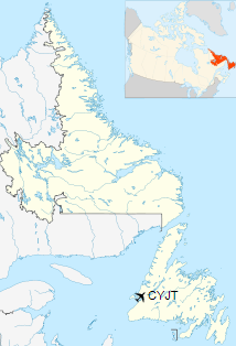
Stephenville Airport (IATA: YJT, ICAO: CYJT) is an airport located 1 nautical mile (1.9 km; 1.2 mi) south southeast of Stephenville, Newfoundland and Labrador, Canada. It was built by the United States Air Force and operated as Ernest Harmon Air Force Base from 1941-1966. The airport serves not only the town of Stephenville, but the city of Corner Brook to the north, and as far south as Port aux Basques, making the total catchment 100,000 people.
The airport is classified as an airport of entry by Nav Canada and is staffed by the Canada Border Services Agency who are able to process general aviation with up to 30 passengers.
CatchmentStephenville Airport provides scheduled and charter air service to a catchment population of approximately 100,000 people, from the city of Corner Brook 65 km (40 mi) to the north to the town of Port aux Basques 120 km (75 mi) to the south.
HistoryIn 1941 the United States obtained rights to construct a United States Army Air Forces base in the St. George's Bay area of Newfoundland. The U.S. 76th Congress approved the 99-year lease and in April 1941, construction began. The USAAF base was built as Stephenville Air Base. However, after the USAAF became the United States Air Force in 1947, it was renamed Ernest Harmon Air Force Base on June 23, 1948, in honour of Captain Ernest Emery Harmon. Harmon was a US Army Air Corps ace who was killed in an air crash in 1933. On September 1, 1943, the Newfoundland Base Command transferred control of Harmon Field to the North Atlantic Wing, Air Transport Command. The base became a part of the Northeast Air Command in October, 1950. Then in April 1957, the Strategic Air Command assumed control.
Airport ramp & terminal building The mandate of the base was to maintain a tanker alert force and its capability to meet and refuel Strategic Air Command jet bombers en route to targets. The Boeing KC-97 Stratofreighter was employed in this task. The base was also used as a refueling stop for transatlantic military flights. In addition, Harmon supported three Air Defense Command units. In 1957, the Canadian Department of Transportation constructed an airport terminal to accommodate Trans-Canada Air Lines (now Air Canada). 1966 saw the closure of the U.S. Air Force Base in Stephenville. The airport is now owned and operated by the local airport authority, the Stephenville Airport Corporation Inc. Stephenville Airport was designated as an alternate in the Trans Oceanic Plane Stop (TOPS) program on 23 July 1970. Since the late 1990s, Stephenville has been designated as one of five Canadian airports suitable as an emergency landing site for the Space Shuttle. The Stephenville Airport was the major passenger airport for all of western Newfoundland until the early 1990s when provincial government decided to direct more traffic to the Deer Lake Regional Airport. All major carriers used Stephenville such as Air Canada, Eastern Provincial Airways and Canadian Airlines. In 1970 the airport was designated by international scheduled air transport and for international general aviation regular use. On February 1, 2018, the Canada Flight Supplement indicated that runway 02/20, which was 3,959 ft (1,207 m) long, had been closed. Development plansThe Newfoundland and Labrador government's plan, called "Taking Flight", aims to enhance air travel in the province by working closely with airports and airlines. For the airlines, if they create a new route, the government can fund the new route up to $750,000 to help promote it. On April 23, 2014, Porter Airlines announced it would operate a seasonal summer service to Halifax Stanfield International Airport between June 28 and August 31, 2014. Operation Yellow RibbonOn September 11, 2001, eight civilian airliners made unscheduled landings at the Stephenville Airport following the closure of North American airspace in the wake of the terrorist attacks on New York City and Washington, DC. As a participant in Operation Yellow Ribbon, the town managed to host nearly 3,000 stranded passengers for approximately one week. Airlines and destinations
Services
Stephenville Airport in 1963
Alternate space shuttle landing siteStephenville Airport was one of five sites along eastern North America designated as an alternate landing site for the Space Shuttle orbiter during its launches and landings.
The content above was published at Airports-Worldwide.com in 2019.
|
||||||||||||||||||||||||||||||||||||||||||||||||||||||||||||||||||||||||||||||||||||||||||||||||||||||||||||||||||||||||||||||||||||||||||||||||||||||||||||||||||||||||||||||||||||||||||||

 |
|
Copyright 2004-2026 © by Airports-Worldwide.com, Vyshenskoho st. 36, Lviv 79010, Ukraine Legal Disclaimer |