 |
|
Pemberton Regional Airport |
Pemberton Regional Airport, (ICAO: CYPS), is a registered aerodrome located 5 nautical miles (9.3 km; 5.8 mi) south southeast of Pemberton, British Columbia, Canada.
|
Pemberton Regional Airport. |
Canadians and a few US pilots practiced landing here, to train for Kandahar, Afghanistan.
| Pemberton Regional Airport |
|
|
| Summary |
| Airport type |
Public |
| Operator |
Village of Pemberton |
| Location |
Pemberton, British Columbia |
| Time zone |
PST (UTC-08:00) |
| Summer (DST) |
PDT (UTC-07:00) |
| Elevation AMSL |
670 ft / 204 m |
| Coordinates |
50°18′09″N
122°44′16″W |
| Website |
www.pemberton.ca/.../pemberton-regional-airport/ |
| Map |
|
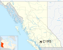
Location in British Columbia
|
| Runways |
| Direction |
Length |
Surface |
| ft |
m |
06/24 |
3,917 |
1,194 |
Asphalt |
|
|
Source: Canada Flight Supplement |
Facilities
There is an automatic weather station, but there are no lights, towers or navigational assistance. The runway is not always plowed in winter. There is Jet A fuel and 100LL available from Blackcomb Aviation with two hours prior notice.
Pemberton Regional Airport Authority
Began by the Pemberton Flying Club circa 1970. Oral history states it was based on a post war "back of the envelope" design by Boeing himself. The airport land was a Federal Crown Grant to the town in 1985. The Pemberton Airport Committee underwent several more incarnations before finally being incorporated under the British Columbia Society Act, in 2007 as Pemberton Regional Airport Authority or PRAA. As with all non-profit societies, all funds and/or profits must be used only for the society.
Tenants and resident airlines
- Coast Range Heliskiing Ltd
- Blackcomb Aviation
- Tyax Adventures. Winter December-May - Ski plane: wheels and skis for landing on a hard surface runway or snow and ice.
- BCFS Fire Attack Base
The above content comes from Wikipedia and is published under free licenses – click here to read more.
| General Info
|
| Country |
Canada
|
| ICAO ID |
CYPS
|
| Latitude |
50.302500
50° 18' 09.00" N
|
| Longitude |
-122.737778
122° 44' 16.00" W
|
| Elevation |
670 feet
204 meters
|
| Magnetic Variation |
018° E (01/06)
|
| Operating Agency |
MUNICIPAL
|
| Daylight Saving Time |
Second Sunday in March at 0200 to first Sunday in November at 0200 local time (Exception Arizona and that portion of Indiana in the Eastern Time Zone)
|
| Communications
|
| CTAF |
123.2
|
| Runways
|
ID
|
Dimensions |
Surface |
PCN |
ILS
|
| 06/24 |
3917 x 100 feet
1194 x 30 meters |
ASPHALT |
- |
NO
|
| Supplies/Equipment
|
| Fuel |
Jet B, Wide cut turbine fuel, Without icing inhibitor.
100/130 MIL Spec, low lead, aviation gasoline (BLUE)
|
The content above was published at Airports-Worldwide.com in 2018.
We don't guarantee the information is fresh and accurate. The data may
be wrong or outdated.
For more up-to-date information please refer to other sources.
|
|


