|
 |
|
||||
|
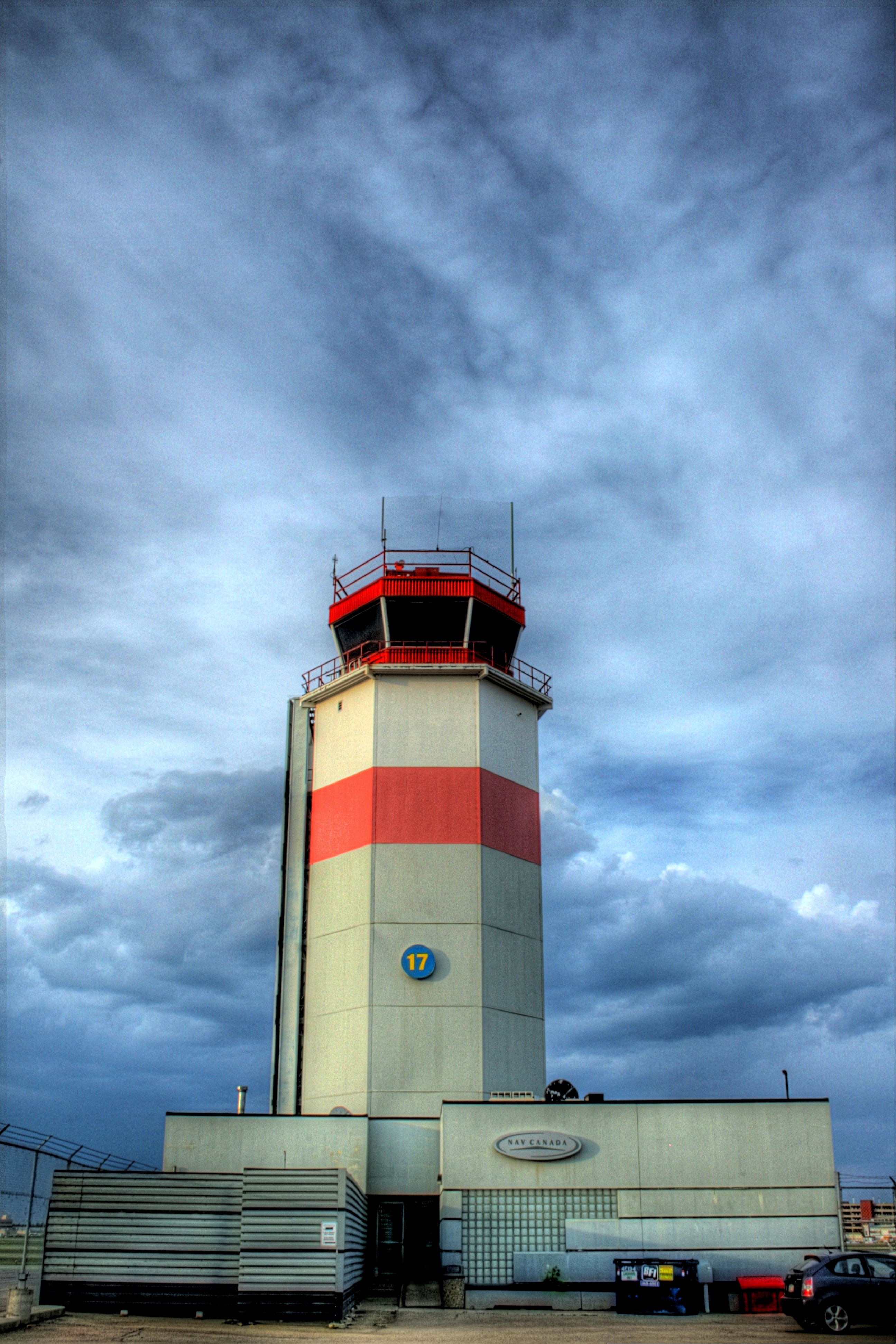
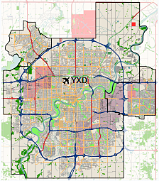
Edmonton City Centre Airport (ECCA), also called Blatchford Field, was an airport located within the city of Edmonton, in Alberta, Canada. It was bordered by Yellowhead Trail to the north, Kingsway to the south, 121 Street to the west, and the Northern Alberta Institute of Technology (NAIT) and Jefferson armouries to the east. It encompassed approximately 144 acres (58 ha) of land just north of the city centre of Edmonton. The airport was originally called Blatchford Field, named for former mayor Kenneth Alexander Blatchford. It later was known as the Edmonton Municipal Airport, then as Edmonton Industrial Airport, and then Edmonton City Centre Airport, finally ending as Blatchford Field at Edmonton City Centre Airport. Over the years, the three letter code «YXD» (IATA: YXD, ICAO: CYXD) continued to be used for the airport by all of the airlines serving the airfield. The airport was closed in November 2013, and as of 2018, the land is being redeveloped by the City of Edmonton as a planned community called Blatchford.
Early historyThe airport has a rich aviation history, being the first licensed airfield in Canada (1929). Characters such as Wop May, a World War I fighter ace and bush pilot, helped pioneer aviation in Alberta and Northern Canada, further solidifying Blatchford Field as the «Gateway to the North». Along with May, the Mayor of Edmonton, Kenny Blatchford, had played a key role in establishing the airport in 1927.Blatchford’s son, Howard Peter Blatchford, became a fighter ace in WWII. Wiley Post landed at the airport during both of his circumnavigations. RCAF Station EdmontonThe airport served as a military airbase during World War II, when it was a major stop-over on the Northwest Staging Route and hosted two British Commonwealth Air Training Plan schools. No. 2 Air Observer School (AOS), operated by Canadian Airways and Canadian Pacific Airlines, opened at RCAF Station Edmonton on August 5, 1940. Later that year, on November 11, the Royal Canadian Air Force (RCAF) established No. 16 Elementary Flying Training School (EFTS), operated by the Edmonton Flying Club; this school was closed on July 17, 1942 to allow for an expansion of No. 2 Air Observer School. Upon winding down of the British Commonwealth Air Training Plan, No. 2 AOS was closed on July 14, 1944. During this period, in about 1942, the aerodrome was listed at 53°34′N 113°31′W with a Var. 25 degrees E and elevation of 2,185 feet (666 m). The facility was listed as being a Department of Transport and RCAF Aerodrome and had three runways, listed as follows:
WeatherA weather station was established in 1937. Over the years since then, its site witnessed increasing influence by the urban heat island effect. By the mid-1970s, «Edmonton Municipal A.» (as it was listed in the Monthly Record of Meteorological Observations in Canada) was regularly recording some of the longest frost-free periods in the Prairie Provinces, with the first fall frost often not coming before October.[citation needed] Scheduled service1950s and 1960sBy the late 1950s, three airlines were providing primary scheduled passenger air service at the airport: major air carriers Canadian Pacific Air Lines (which would become CP Air) and Trans-Canada Air Lines (TCA, which would become Air Canada) as well as regional air carrier Pacific Western Airlines (PWA). In 1959, Canadian Pacific was operating international service to Europe with four nonstop flights a week flown with Douglas DC-6B «Empress» propliners between Edmonton and Amsterdam with these flights originating and terminating in Vancouver and was also operating local domestic service with Convair 240 prop aircraft to Grande Prairie, Alberta and Fort St. John, British Columbia. A year earlier in 1958, Trans-Canada was flying Lockheed L-1049 Super Constellation and Canadair North Star (a Canadian produced version of the Douglas DC-4) propliners in addition to Vickers Viscount turboprops on nonstop services to Vancouver, Toronto, Winnipeg and Saskatoon as well as direct, no change of plane flights to Montreal. According to the June 1, 1958 Trans-Canada Air Lines system timetable, the air carrier was also operating five nonstop departures a day to Calgary with Viscount propjets. Pacific Western was operating regional services from the airport in 1959 with Curtiss C-46 and Douglas DC-4 prop aircraft to a number of Canadian destinations located north of Edmonton including Fort McMurray, Fort Smith, Fort Resolution, Fort Vermilion, Hay River, Inuvik, Norman Wells, Peace River, Uranium City, and Yellowknife. By 1964, Pacific Western had expanded its domestic service from the airport with the addition of regional flights to Cambridge Bay, Coppermine, Dawson Creek, Fort Simpson and Wrigley as well as to the Resolute Bay Airport in the Arctic which is the northernmost destination in Canada served by scheduled airline flights. By 1968, Pacific Western had introduced Convair 640 turboprop aircraft (which the airline called the «Javelin Jet-Prop») on many of its flights from the airport and had also introduced its «Chieftain Airbus» shuttle service linking Edmonton and Calgary operated with Douglas DC-6 propliners with six round trip nonstop flights a day between the two cities. According to the June 24, 1968 Pacific Western system timetable, Douglas DC-6 and DC-6B passenger aircraft as well as all-cargo DC-4 aircraft were also being operated by the airline to destinations located north of Edmonton. The jet age arrived at the airport in 1969 when Pacific Western introduced Boeing 737-200jetliners with nonstop flights to Calgary, Fort Smith and Hay River with direct, no change of plane 737 jet service to Vancouver, Yellowknife, Kamloops, Kelowna, Cranbrook, Penticton, Inuvik and Norman Wells. 1970s and 1980s
Several types of jet passenger aircraft were operated into ECCA, notably the Boeing 737-200. As noted above, these 737 flights were initially operated by Pacific Western Airlines followed by its successor Canadian Airlines (formerly CP Air) from the initial purchase of these aircraft in the late 1960s up until the merger of Pacific Western with Canadian with the latter continuing to operate 737 flights into the airport. Pacific Western flew its «Chieftain Airbus» shuttle service between the airport and Calgary (YYC) for many years with the 737 and in 1976 was operating up to fourteen Boeing 737-200 departures a day nonstop from ECCA to YYC in addition to operating direct 737 jet flights into the airport from Castlegar, BC, Cranbrook, BC, Dawson Creek, BC, Fort Chipewyan, AB, High Level, AB, Kamloops, BC, Kelowna, BC, Peace River, AB, Penticton, BC, Prince George, BC, Uranium City, SK and Vancouver, BC. The runway lengths at ECCA mandated the absolute maximum performance characteristics of the Boeing 737-200 jetliner due to its weight; however, the extreme wear caused by utilising this airfield and pushing these limits was a concern. Other jet service came in the form of the British Aerospace BAe 146-200 as Air Canada Connector flights operated by Air BC on behalf of Air Canada. McDonnell Douglas DC-9-30s in Air Canada livery operated briefly out of ECCA in the early 1980s but left due to field/weight limitations. Time Air and its later brand of Canadian Regional operated Fokker F28 Fellowship twin jets, while Echo Bay Mines Limited operated a private passenger/cargo Boeing 727-100 combi aircraft trijet from the field for several years. Time Air previously operated Fokker F27 Friendship and de Havilland Canada DHC-6 Twin Otter turboprop aircraft from the airfield during the mid 1970s and de Havilland Canada DHC-7 Dash 7 turboprops during the early 1980s. Both the Twin Otter and Dash 7 have short takeoff and landing (STOL) capabilities so runway length was not an issue for these aircraft types. Besides operating flights with 737 jets, Pacific Western also operated Lockheed L-188 Electra turboprop service from the airport during the mid 1970s with nonstop flights to Fort Chipewyan, Fort McMurray and Peace River in Alberta province as well as direct to Fort Smith, NWT and Yellowknife, NWT. By 1985, Pacific Western was operating up to sixteen nonstop Boeing 737-200 departures a day from the airport to Calgary on its «Chieftain Airbus» shuttle schedule linking the two cities. According to the April 28, 1985 Pacific Western system timetable, the airline was also operating direct, no change of plane 737 jet service from the airport to the Canadian destinations of Vancouver, Toronto, Winnipeg, Regina, Saskatoon, Cranbrook, BC, Fort McMurray, Kamloops, Kelowna and Penticton. The airline had become an all-jet air carrier with a fleet of 737 aircraft at this time. The airport also had service to the U.S. during the mid 1980s. In 1985, Pacific Western was operating direct, no change of plane Boeing 737-200 jet service to Seattlevia intermediate stops at Calgary and Vancouver. In 1987, Continental Airlines in conjunction with Pacific Western was operating two flights a day to Texas with direct service to Dallas/Fort Worth (DFW) and Houston (IAH). Pacific Western operated the Edmonton-Calgary portion of the service with Boeing 737-200s and passengers then transferred to Continental operated Boeing 727-100 jetliners in Calgary for the flights to Texas. According to the February 1, 1987 Continental timetable, the respective routings of these flights were YXD-YYC-DFW-IAH and YXD-YYC-IAH, and both services were operated with Continental flight numbers. 1990sBy 1995, three different airlines were operating a combined total of up to thirty-two (32) nonstop flights a day from the airport to Calgary according to the Official Airline Guide (OAG). Canadian Airlines International was operating flights between ECCA and Calgary with Boeing 737-200 jetliners while Time Air flying as Canadian Partner on behalf of Canadian via a code sharing agreement was operating Fokker F28 jets and de Havilland Canada DHC-8 Dash 8 turboprops. Air BC operating as Air Canada Connector on behalf of Air Canada via a code sharing agreement was flying British Aerospace BAe 146-200 jets and de Havilland Canada DHC-8 Dash 8turboprops on the route at this same time. Final years (2000–2013)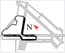
Overlay of the pre-2011 Edmonton IndyCar track on an airport map. In its final years, before closing in 2013, the airport was mainly used for air charter, general aviation, flight training and medivac (air ambulance). In addition, from 2005 to 2012, the airport was annually converted into a speedway for the Edmonton Indy Champ Car race. In 2008 Champ Car merged with the Indy Racing League, and became the IndyCar Series. The NASCAR Canadian Tire Seriesalso raced at the speedway in 2007, 2008, 2009, 2010, and 2012. Beginning with the July 2011 event, the track layout was reconfigured to use a more northeasterly section of the airport, including Runway 16/34 (which had been permanently closed). Obsolescence and closureDebateThe fate of the Edmonton City Centre Airport (ECCA) was fiercely debated for decades, beginning in the 1950s. To accommodate demands for ever-increasing range, new generations of jet aircraft became increasingly larger and heavier, resulting in the need for a longer set of runways. It became clear that it would be economically and in many cases physically impossible to accommodate modern jet aircraft at ECCA. With no ability to expand the runways, a search began for a site for construction of a new international airport. Edmonton entered into fifty years of airport debates shaped by issues of logistics, transportation, and regional disparities. To the north of the city, a World War II military base (now CFB Edmonton) had been built at Namao by the United States Army Air Forces. In the 1950s, the base was expanded to handle Strategic Air Command military bomber aircraft, including the longest runway in Canada. Leduc, Alberta, located 14 NM (26 km; 16 mi) south by southwest of downtown Edmonton, was chosen as the site for the Edmonton International Airport (IATA: YEG, ICAO: CYEG). It was initially decided that ECCA would be closed in 1963, upon completion of a new passenger terminal at Edmonton International. However, the issue was reexamined by consultants, and particularly in view of the unforeseen development of regional airliner service at ECCA, especially to Calgary, the City of Edmonton decided to keep ECCA open and operate both airports. In Edmonton’s 1992 municipal election, the City of Edmonton held a plebiscite, the Edmonton Municipal Airport Referendum. The result of the referendum was that Bylaw No. 10,205, which kept ECCA open to all traffic that the field could legally handle, was approved with a vote of 54%. In the 1995 election, a second plebiscite was put forth to the citizens of Edmonton asking if the bylaw should be repealed on the basis of consolidating all scheduled traffic at Edmonton International. Determination of whether or not to close the airport was not given as an option. 77% of voters approved the proposed version, and in June 1996, the consolidation process was finalized. ClosureOn July 8, 2009, the city council decided on a phased closure of the airport. The Alberta Aviation Museum and some non-aviation institutions were to remain, with some land transferred to Northern Alberta Institute of Technology, and the rest converted to a primarily residential development. The north-south runway, Runway 16/34, was to be the first runway closed. The closure was postponed until after the Indy and Airfest events of 2010. On August 3, 2010, Runway 16/34 was closed to air traffic with a Notice to Airmen being issued at 3:00 am that morning. Closure of the remaining runway, Runway 12/30, was announced at an Edmonton City Council meeting on September 26, 2013. Licenses for scheduled air service were not renewed. On the afternoon of November 30, 2013, the last airplane to leave the airfield was a Cessna 172, owned and piloted by a local. Weather prevented a pair of CF-18 fighter jets from performing a touch-and-go landing as the ceremonial last takeoff. Shortly afterwards, ERAA placed barricades on Runway 12/30 to prevent access, and markers were placed to clearly signal to pilots that it was closed. On February 21, 2015, a Pipistrel Virus aircraft C-FCDZ flying over the site of the airport suffered a propeller failure, resulting in an unplanned landing on the airport grounds using the plane’s ballistic parachute. Blatchford communityAs of 2018, 525 acres of the former Blatchford Field is undergoing redevelopment into a medium and high density neighbourhood. The Blatchford area will be broken into five boroughs: Blatchford West, Blatchford East, Blatchford Park, Civic Plaza, and Town Centre. Blatchford West, the first borough to be developed, will have more than 6,000 townhouses and apartments, while Blatchford East will have more than 4,000 townhouses and apartments.Blatchford Park will be around 120 acres in size and will include a large lake. The Town Centre and Civic Plaza will accommodate various businesses, markets, shops, and an LRT light rail transit station. Airport facilities (historical)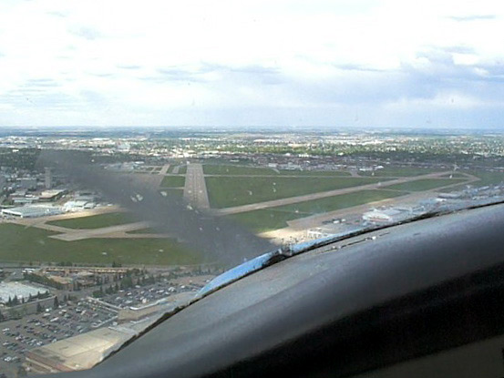
On approach, runway 30 Airfield and runwaysThe field elevation was 2,202 ft (671 m).
Due to the airport’s location in the central portion of the city, there were both curfew restrictions and noise abatement procedures. The field maintained 24 X 7 operations, with the strictest noise regulations in effect from 22:00h to 07:00h local time. Facilities and amenitiesFor private and corporate aviation, there were two fixed-base operators (FBO) on site, located on the west side of the airfield off Taxiway A. On-site amenities included the Alberta Aviation Museum, two hotels, and a cafeteria in the Edmonton Flying Club’s building. A flight school was operated at Centennial Flight Centre. Private air ambulances used the Esso Avitat hangar to store their ground support units. A STARS air ambulance was also based at the airport. Further amenities located close to the airport included shopping at Kingsway Mall, lodging at the Chateau Louis hotel, and a Via Rail train station to the north, off Bush Pilot Road. The Alberta and Edmonton office for St. John Ambulance was located nearby. Proximity to the Royal Alexandra Hospital provided a link for emergency medical access by air to many of Alberta’s rural communities. https://en.wikipedia.org/wiki/Edmonton_City_Centre_(Blatchford_Field)_Airport
The content above was published at Airports-Worldwide.com in 2018.
|
||||||||||||||||||||||||||||||||||||||||||||||||||||||||||||||||||||||||||||||||||||||||||||||||||||||||||||||||||||||||||||||||||||||||||||||||||||||||||||||||||||||||||||||||||||||||||||||||||||||||||||||||||||||

 |
|
Copyright 2004-2026 © by Airports-Worldwide.com, Vyshenskoho st. 36, Lviv 79010, Ukraine Legal Disclaimer |