|
|
Drumheller Municipal Airport |
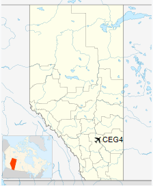
Drumheller Municipal Airport, (TC LID: CEG4), is located 3 nautical miles (5.6 km; 3.5 mi) northwest of Drumheller, Alberta, Canada.
| Drumheller Municipal Airport |
- IATA: none
- ICAO: none
- TC LID: CEG4
|
| Summary |
| Airport type |
Public |
| Operator |
Town of Drumheller |
| Location |
Starland County, near Drumheller, Alberta |
| Time zone |
MST (UTC−07:00) |
| • Summer (DST) |
MDT (UTC−06:00) |
| Elevation AMSL |
2,599 ft / 792 m |
| Coordinates |
51°29′47″N
112°44′55″W |
| Map |
|
|
| Runways |
| Direction |
Length |
Surface |
| ft |
m |
| 16/34 |
3,505 |
1,068 |
Asphalt |
|
The above content comes from Wikipedia and is published under free licenses – click here to read more.
| General
Info
|
| Country |
Canada
|
| Latitude |
51.496389
51° 29' 47.00" N
|
| Longitude |
-112.748610
112° 44' 55.00" W
|
| Elevation |
2597
feet
792 meters
|
| Magnetic
Variation |
015°
E (01/06)
|
| Beacon |
Yes
|
| Operating
Agency |
MUNICIPAL
|
| Daylight
Saving Time |
Second
Sunday in March at 0200 to first Sunday in November at 0200 local
time (Exception Arizona and that portion of Indiana in the Eastern
Time Zone) |
| Communications
|
| CTAF/UNICOM |
122.8
|
| Runways
|
| ID |
Dimensions |
Surface |
PCN |
ILS
|
| 16/34
|
3500
x 75 feet
1067 x 23 meters |
ASPHALT |
- |
NO
|
| Navaids
|
| Type |
ID |
Name |
Channel |
Freq |
Distance
From Field |
Bearing
From Navaid
|
| NDB-DME |
5V |
DRUMHELLER |
037X |
395 |
At
Field |
-
|
The content above was published at Airports-Worldwide.com in 2018.
We don't guarantee the information is fresh and accurate. The data may be wrong or outdated.
For more up-to-date information please refer to other sources.
|
|