|
|
Naypyitaw Airport
နေပြည်တော် အပြည်ပြည်ဆိုင်ရာ လေဆိပ် |
 |
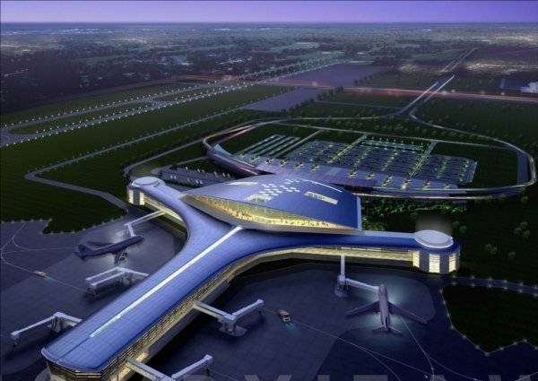
| A layout plan of future Naypyidaw International Airport |
| IATA: ELA – ICAO: VYNT |
| Summary |
| Airport type |
Public |
| Operator |
Ministry of Transport |
| Serves |
Naypyidaw |
| Location |
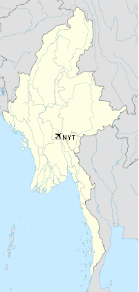
Naypyidaw, Myanmar |
| Elevation AMSL |
109 ft / 33 m |
| Coordinates |
19°37′08.87″N 96°11′59.78″E / 19.6191306°N 96.1999389°E / 19.6191306; 96.1999389Coordinates: 19°37′08.87″N 96°11′59.78″E / 19.6191306°N 96.1999389°E / 19.6191306; 96.1999389 |
| Runways |
| Direction |
Length |
Surface |
| ft |
m |
| 16/34 |
12,000 |
3,657 |
Concrete |
Naypyidaw Airport, (Burmese: နေပြည်တော် အပြည်ပြည်ဆိုင်ရာ လေဆိပ်; previously known as Ela Airport), is located 16 km southeast of Naypyidaw, the capital of Myanmar. Before the foundation of Naypyidaw, this was referred to as the airport of the nearby town of Pyinmana. The airport is undergoing a major expansion project that will enable it to handle 3.5 million passengers annually by 2011.
Expansion project
The design of Naypyidaw International Airport was drawn by CPG Consultants Pte., Ltd. Of Singapore. The company drew the design of the annex to Yangon International Airport, and the designs of Changi Airport of Singapore and several airports of Vietnam and Laos. The construction work of the airport is carried out by Asia World Company. At the end of the master plan, the airport will have 2 runways and 3 terminals with modern facilities. The airport is planned to go according to the three phases.
Phase 1 (2009- mid 2011)
The phase 1 comprises
- An airport building that can cope with 3.5 million passengers
- A taxiway with 3700 meters in length and 30.5 meters in width
- A 403 meters long and 336 meters wide apron with a total area of 135,408 square meters where 10 aircrafts can land simultaneously
- Boarding bridges,
- An annex to the airport
- A control tower
- A car parking and
- Other facilities.
Annually, 2 million international passengers, 1.5 million local passengers totaling 3.5 million can use the main airport building which is made up of
- the main hall with an area of 17,174 square meters,
- the east hall and west hall with an area of 3224 square meters each and
- the north hall with an area of 5912 square meters.
The total area of the ground floor, the attic and the first floor of the whole building is 63,000 square meters.
The airport building is a two-storey building with reinforced concrete boree piles. The ground floor is for passenger arrivals and the first floor for passenger departures. The west hall is for local passengers, the east hall, and the north hall for international passengers.
The approach road to the airport with two ways / four lanes is 1500 meters long. The car parking measures 200 meters by 107 meters and its total area is 21,400 square meters. The 62- meter-high control tower can control all the construction tasks of the first, second and third phases of the project.
Phase 2
The second phase project includes an apron measuring 1200 feet x 1200 feet in front of the already-constructed airport building, an apron where VIP aircraft lands and building four more boarding bridges at the airport building for passengers, a flight catering building, a government complex and an airport maintenance base.
Phase 3
The third phase includes 17 more boarding bridges, a dual parallel taxiway measuring 1200 ft x 100 ft, a runway measuring 12000 ft x 100 ft in front of the airport building, a set of dual parallel taxiway measuring 12,000ft x 100 ft, four taxways measuring 650 ft x 100 ft, four taxways measuring 550 ft x 100 ft and an apron for cargo planes. After the third phase is completed, the airport will be able to cope with 10.5 million passengers annually and it will be more modern and sophisticated than Yangon International Airport and Mandalay International Airport.
Airlines and destinations
| Airlines |
Destinations |
| Air Bagan |
Yangon |
| Air Mandalay |
Yangon |
| Yangon Airways |
Yangon, Heho |
The above content comes from Wikipedia and is published under free licenses – click here to read more.
| General Info
|
| Country |
Burma
|
| ICAO ID |
VYEL
|
| Time |
UTC+6:30
|
| Latitude |
19.623500
19° 37' 24.60" N
|
| Longitude |
96.201028
096° 12' 03.70" E
|
| Elevation |
302 feet
92 meters
|
| Magnetic Variation |
000° W (05/06)
|
| Beacon |
Yes
|
| Operating Agency |
CIVIL GOVERNMENT, (LANDING FEES AND DIPLOMATIC CLEARANCE MAY BE REQUIRED)
|
| Alternate Name |
ELA
|
| Near City |
Pyinmana
|
| Communications
|
TWR
HO
|
118.7
|
| Runways
|
| ID |
Dimensions |
Surface |
PCN |
ILS
|
| 16/34 |
12000 x 500 feet
3658 x 152 meters |
CONCRETE. |
- |
NO
|
| Navaids
|
| Type |
ID |
Name |
Channel |
Freq |
Distance From Field |
Bearing From Navaid
|
| NDB |
EL |
EL |
- |
390 |
At Field |
-
|
| Remarks
|
| OPR HOURS |
HO - on request
|
The content above was published at Airports-Worldwide.com in 2010.
We don't guarantee the information is fresh and accurate. The data may be wrong or outdated.
For more up-to-date information please refer to other sources.
|
|