 |
|
Guararapes Gilberto Freyre Intl Airport |
Recife/Guararapes - Gilberto Freyre International Airport
Aeroporto Internacional do Recife/Guararapes - Gilberto Freyre |
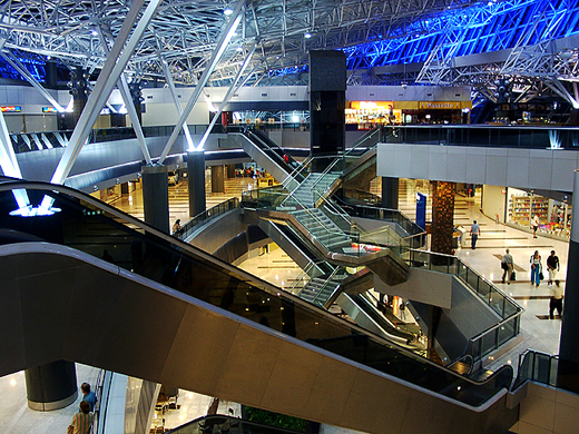 |
| Inside view of the airport. |
| IATA: REC – ICAO: SBRF |
| Summary |
| Airport type |
Military/Public |
| Operator |
Infraero |
| Serves |
Recife |
| Elevation AMSL |
33 ft / 10 m |
| Coordinates |
08°07′35″S 34°55′24″W / 8.12639°S 34.92333°W / -8.12639; -34.92333Coordinates: 08°07′35″S 34°55′24″W / 8.12639°S 34.92333°W / -8.12639; -34.92333 |
| Website |
Infraero REC |
| Runways |
| Direction |
Length |
Surface |
| ft |
m |
| 18/36 |
10,875 |
3,315 |
Asphalt |
| Statistics (2009) |
| Passengers |
5,250,565 |
| Aircraft Operations |
66,415 |
| Metric tonnes of cargo |
40,400 |
Statistics: Infraero
Sources: Airport Website |
Guararapes International Airport (IATA: REC, ICAO: SBRF), also known as Gilberto Freyre International Airport, is an international airport located in the city of Recife, Brazil. It serves domestic and international air traffic.
In 2009, the airport handled 5,249,831 passengers and 66,414 aircraft movements, placing it the 8 busiest airport in Brazil in terms of passengers and 5 busiest in terms of cargo (6 in terms of cargo plus mail). History
The shopping and leisure area has been remodeled since July 2004, using the "Aeroshopping" concept, which transformed the airport into a center for office and commercial use in an area of 52,000 square meters. The commercial spaces will be occupied in stages and the final total will be 142 shops. The parking structure has been in use since December 2002. There are three levels with a total capacity for 2,080 vehicles, previously there were only 500 parking spaces. There is an events and exhibitions space located on the fourth level. The airport's capacity was expanded from 1.5 million to 5 million passengers a year which was almost fulfilled in 2008 with more than 4.6 million passengers. There are plans to increase capacity to 7.2 million. There is a pipeline running underneath carrying kerosene to fuel the airplanes, the safest way to do this because it does away with the need for tank trucks in the maneuvering area.
The airport is 1 km from Boa Viagem beach, 14 km from downtown and 25 km from Suape port.
In the vicinity of the airport is located Cindacta III, the Brazilian Integrated Air Traffic Control and Air Defense Center section 3.
Airlines and destinations
| Airlines |
Destinations |
| American Airlines |
Miami |
| Avianca Brazil |
Petrolina, Salvador da Bahia |
| Azul Brazilian Airlines |
Belo Horizonte-Confins, Campinas-Viracopos |
| Gol Airlines |
Belo Horizonte-Confins, Brasília, Campina Grande, Campinas-Viracopos, Fernando de Noronha, Fortaleza, Juazeiro do Norte, Natal, Petrolina, Porto Alegre, Rio de Janeiro-Galeão, Salvador da Bahia, São Paulo-Congonhas, São Paulo-Guarulhos |
| Iberia |
Madrid [begins 1 February] |
| Noar Linhas Aéreas |
Aracaju, Caruaru, João Pessoa, Maceió, Mossoró, Natal |
| Passaredo Linhas Aéreas |
Ribeirão Preto |
| TAM Airlines |
Aracaju, Belém, Belo Horizonte-Confins, Brasília, Buenos AIres-Ezeiza, Campinas-Viracopos, Curitiba-Afonso Pena, Fortaleza, Foz do Iguaçu, João Pessoa, Maceió, Manaus, Natal, Porto Alegre, Rio de Janeiro-Galeão, Rio de Janeiro-Santos Dumont, Salvador da Bahia, São Luis, São Paulo-Guarulhos, São Paulo-Congonhas |
| TAM Airlines operated by Pantanal Linhas Aéreas |
Brasília |
| TAP Portugal |
Lisbon |
| TRIP |
Aracaju, Fernando de Noronha, Natal, Maceió, São Paulo-Guarulhos |
| Webjet |
Brasília, Cuiabá, Fortaleza, Maceió, Porto Alegre, Rio de Janeiro-Galeão, Salvador da Bahia, Sāo Paulo-Guarulhos |
Accidents and incidents
- 1 November 1961: Panair do Brasil, a Douglas DC-7C registration PP-PDO flying from Lisbon to Rio de Janeiro-Galeão via Sal and Recife, during its final approach at Recife, struck an 84m hill 2.7 km from the runway and broke-up. The aircraft was doing a night approach too low and outside the regular traffic pattern. All 45 passengers and crew died.
- 14 March 1970: Paraense, a Fairchild Hiller FH-227B registration PP-BUF flying from Recife to Belém, while on final approach to land at Belém, crashed into Guajará Bay. Of the 40 passengers and crew, 2 survived.
- 14 December 1987: Brazilian Air Force, a Lockheed C-130H Hercules registration FAB-2468, flying from Recife to Fernando de Noronha, crashed into the sea shortly before landing. All 29 crew and passengers died.
- 20 September 1990: a Embraer EMB110P1 Bandeirante registration PT-PAW belonging to the Government of Pernambuco, flying from Fernando de Noronha to Recife, crashed into the sea shortly after take-off. All 12 crew and passengers died.
Future developments
On 31 August 2009, Infraero unveiled a BRL8.75 million (USD4.6 million; EUR3.2 million) investiment plan to up-grade Guararapes International Airport focusing on the preparations for the 2014 FIFA World Cup which will be held in Brazil, Recife being one of the venue cities. The investment will be distributed at the conclusion of the renovation of the passenger terminal with installation of another 8 bridges to be completed in February 2010.
The above content comes from Wikipedia and is published under free licenses – click here to read more.
| General Info
|
| Country |
Brazil
|
| ICAO ID |
SBRF
|
| Time |
UTC-3(-2DT)
|
| Latitude |
-8.126794
08° 07' 36.46" S
|
| Longitude |
-34.923039
034° 55' 22.94" W
|
| Elevation |
33 feet
10 meters
|
| Type |
Joint (Civil and Military)
|
| Magnetic Variation |
022° W (07/06)
|
| Beacon |
Yes
|
| Operating Agency |
MILITARY - CIVIL JOINT USE AIRPORT
|
| Near City |
Recife
|
| Operating Hours |
24 HOUR OPERATIONS
|
| International Clearance Status |
Airport of Entry
|
| Communications
|
| RECIFE TWR |
122.8
118.35
|
| RECIFE OPS |
122.5
|
| GND |
121.85
|
| ATIS |
127.65
|
| RECIFE APP |
119.1
119.5
119.95
121.5
|
| Communications Remarks |
|
| TWR |
(122.8 Mil) (118.35 Civ)
|
| Runways
|
| ID |
Dimensions |
Surface |
PCN |
ILS
|
| 18/36 |
9865 x 148 feet
3007 x 45 meters |
ASPHALT |
063FBXT |
YES
|
| Navaids
|
| Type |
ID |
Name |
Channel |
Freq |
Distance From Field |
Bearing From Navaid
|
| VOR-DME |
REC |
RECIFE |
116X |
116.9 |
At Field |
-
|
| Supplies/Equipment
|
| Fuel |
Jet A1, without icing nhibitor.
100/130 octane gasoline, leaded, MIL-L-5572F (GREEN)
|
| Other Fluids |
LPHOX, Low pressure oxygen servicing
|
| Remarks
|
| CAUTION |
Bird haz. ILS antenna 39' hgt 1181' fr thld Rwy 18. Crossing of vehicles and equip on the hangar aprons. Antenna 1004' hgt, 7.6 NM, 311 fr thld Rwy 18. Exer caution on DELTA twy btn hangar 1/6 GAV and new embarkation unit office due torstd vis with TWR/GND. Antenna 1060' hgt, 7.6 NM, 31 fr thld Rwy 18.
|
| FLUID |
LPOX
|
| FUEL |
(NC-100, A1)
|
| LGT |
PAPI Rwy 18-36 MEHT 64'.
|
| MISC |
Air file flt pln proh. Flt pln acpt by phone.
|
| NS ABTMT |
Accomplish specific pro of eqpt.
|
| RSTD |
Jet and/or turboprop acft proh to carry out manuevers at mil area. Acft 40 tonsor more must perform pushback ops to leave prk area. Ops of acft only up to B-737 allowed on Twy GOLF and KILO. AMC chan msn will nml prk on civ ramp, while special msn will nml prk on mil ramp. Rwy 18-36 (Twy Mike) not avbl for simultaneous ldg and tkof for acft with wing-span greater than 170 FT. No area for eng runup; use portion of Mike twy btn holding pt of Rwy 18 and Alfa twy, fr 0900-0000Z++, coord with afld admin.
|
The content above was published at Airports-Worldwide.com in 2010.
We don't guarantee the information is fresh and accurate. The data may be wrong or outdated.
For more up-to-date information please refer to other sources.
|
|


