|
|
Thebephatshwa Airport (ICAO: FBTP) is an airport serving Thebephatshwa, in the Kweneng District of Botswana. The airport is 24 kilometres (15 mi) northwest of Molepolole.
|
Thebephatshwa Airport
|
|
|
| Summary |
| Airport type |
Military/Public |
| Owner |
Botswana Defence Force |
| Serves |
Thebephatshwa |
| Elevation AMSL |
3,750 ft / 1,143 m |
| Coordinates |
24°13′15″S
25°20′55″E |
| Map |
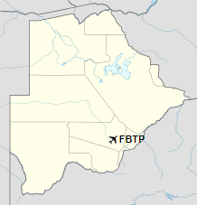
Location of Thebephatshwa Airport in Botswana
|
| Runways |
| Direction |
Length |
Surface |
| m |
ft |
| 08/26 |
3,000 |
9,843 |
Asphalt/Concrete |
|
The above content comes from Wikipedia and is published under free licenses – click here to read more.
| General Info
|
| Country |
Botswana
|
| ICAO ID |
FBTP
|
| Latitude |
-24.221122
24° 13' 16.04" S
|
| Longitude |
25.347272
025° 20' 50.18" E
|
| Elevation |
3750 feet
1143 meters
|
| Type |
Military
|
| Magnetic Variation |
014° W (05/06)
|
| Operating Agency |
MILITARY
|
| Alternate Name |
MOLEPOLOLE AIR BASE
|
| Runways
|
| ID |
Dimensions |
Surface |
PCN |
ILS
|
| 08/26 |
9850 x 148 feet
3002 x 45 meters |
ASPHALT |
- |
NO
|
| 08L/26R |
6585 x 60 feet
2007 x 18 meters |
ASPHALT |
- |
NO
|
| Supplies/Equipment
|
| Fuel |
Jet fuel avaiable but type is unknown.
|
The content above was published at Airports-Worldwide.com in 2019.
We don't guarantee the information is fresh and accurate. The data may be wrong or outdated.
For more up-to-date information please refer to other sources.
|
|