|
 |
|
||||
|
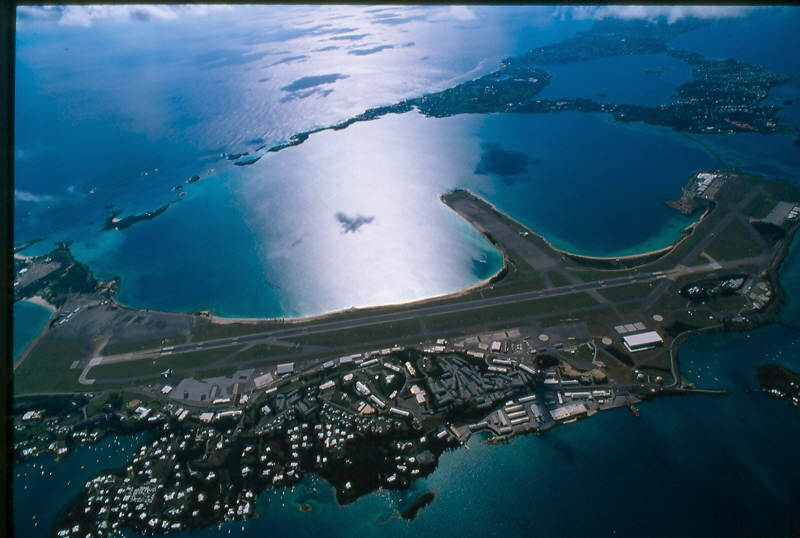
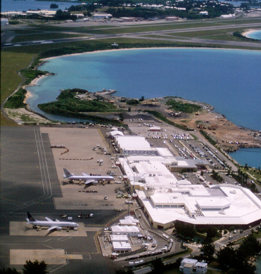
L.F. Wade International Airport (IATA: BDA, ICAO: TXKF), formerly named Bermuda International Airport, is the sole airport serving Bermuda, a British overseas territory in the North Atlantic Ocean. It is located in the parish of St. George's and is 10 miles (16 km) east of Bermuda's capital city of Hamilton. In 2006, L.F. Wade International Airport handled about 900,000 passengers, up 7% from 2005. It has one passenger terminal, one cargo terminal, eight aircraft stands and can support all aircraft sizes up to and including the Boeing 747. Currently, ten airlines operate seasonal or year-round scheduled services to Bermuda Airport from Canada, the United Kingdom, and the United States. The largest aircraft now operating in regularly scheduled service at BDA are British Airways' Boeing 777-200s. HistoryThe airfield began life as Kindley Field, a joint US Army Air Forces (USAAF)/Royal Air Force (RAF) base, during the Second World War. The RAF forces in Bermuda were withdrawn at the end of the War. The local RAF Commander, however, stayed on, on loan to the Bermuda Government, and converted the RAF facilities into the Civil Air Terminal, operated by the local government. When the pre-War airport, a flying boat facility on Darrell's Island, closed in 1948, Bermuda's air routes were taken over by land planes operating through the airfield, which by then was operated by the United States Air Force, as Kindley Air Force Base. In 1970, the field was transferred to the United States Navy, which operated it as US Naval Air Station, Bermuda until 1995 when the US Navy terminated its 99-year lease and the field was transferred to the Bermuda Government, which now operates the airport as part of the Ministry of Tourism & Transport. The US Navy was not required to meet international civil air standards, despite the operation of civil airlines to the base. The Bermuda Government, however, was required to meet these standards very quickly on assuming control, and at some expense. This involved changes to the airfield lighting, erecting new fences, levelling anything over a certain height and within a certain distance of the runway (including the former base commander's residence, and the hill it stood on), and other changes. The airport is located at the west of St. David's Island, and to the south of Ferry Reach. This places it in the East End of the archipelago, several miles from the current capital, Hamilton. The airfield was constructed between 1941 and 1943 by levelling Longbird Island and several smaller islands, and filling in the waterways between them and St. David's Island. This created a landmass contiguous with St. David's, and the airfield is typically described as being in, or on, St. David's. The field originally had three runways, but only the longest is still in use. One of the others, most of which lies on a narrow peninsula, which juts into Castle Harbour, has been blocked by munitions bunkers that were built at the harbour end. There are further bunkers on the west side of the peninsula, and the US Navy had referred to the area as the Weapons Pier. Airport workers, today, refer to it as The Finger. The other former runway is used today as a taxiway to connect aprons one and two to the active runway, and the taxiway which parallels it. This was last used as a runway in 1978. It has its own former taxiway paralleling it, which now serves as a dispersal area for visiting aircraft. On 16 April 2007, the airport was formally renamed "L.F. Wade International Airport" in honour of L. Frederick Wade, a past leader of the incumbent Governing party (the Progressive Labour Party) when it was in opposition. The name was criticised by the opposition United Bermuda Party for being politically biased.
Current operationsIn 2006, the airport handled almost one million passengers and had 258 airline flight arrivals and departures weekly during the peak June - August summer season. It has received high marks in passenger satisfaction surveys, placing first among North American airports in the "Under 15 million passengers" category in 2003 and fourth world-wide in its size category, according to the global airport monitor report that year. Cited were courtesy of staff, security, and check-in facilities. The former NATO hangar built in the early 1990s is now used for the airport's growing corporate jet traffic. Because of Bermuda's considerable distance from the nearest land mass, the airport's use by General Aviation aircraft is limited to jets and long-range turboprops. Only jet fuel is available. The airport offers U.S. Customs and Immigration preclearance, which means U.S.-bound passengers clear Customs in Bermuda; flights arriving in the U.S. from Bermuda are thus treated as domestic flights. Air traffic control service is provided by BAS-Serco under contract to the DAO. The control tower is located on the north side of the airport (not to be confused with the old tower located at the terminal building) and provides service for most of the day and night. Approach, departure and enroute traffic control in the surrounding Oceanic Sector is provided by New York Air Route Traffic Control Center (ZNY), under an agreement between the U.S. Government's Federal Aviation Administration and the United Kingdom. The BDA tower controller and ZNY center controller are always in close contact. Remote radio transmitters and air traffic radar coverage at the airport also link Bermuda and New York Center. A modern Doppler Weather Radar with a 150 mi. range was built by the DAO in 2005. Navaids at the airport, such as the Instrument Landing System (ILS) and VOR (VHF omnidirectional range), are owned by the DAO but maintained by BAS-Serco. The airport is a United States government NASA Space Shuttle launch abort site. It can only be used during low and mid inclination launches. The airport is also active in affairs of the Airports Council International, hosting the industry organisation's Legal Affairs Committee annual meeting in 2005. In 2006, Bermuda International Airport was selected as host for the Airport Council International's annual worldwide convention in 2010. Airport agencies
Airlines and destinationsPassenger
Cargo
Accidents and incidentsOn 6 December 1952 A Cubana de Aviación DC-4 crashed after taking off from the airport killing 37 passengers out of 41 passengers and crew. See 1952 Bermuda air crash The above content comes from Wikipedia and is published under free licenses – click here to read more.
The content above was published at Airports-Worldwide.com in 2010. |
||||||||||||||||||||||||||||||||||||||||||||||||||||||||||||||||||||||||||||||||||||||||||||||||||||||||||||||||||||||||||||||||||||||||||||||||||||||||||||||||||||||||||||||||||||||||||||||||||||||||||||||||||||||||||

 |
|
Copyright 2004-2026 © by Airports-Worldwide.com, Vyshenskoho st. 36, Lviv 79010, Ukraine Legal Disclaimer |