 |
|
|
|
|
|
 Operator: Rural City of Wangaratta
Address:
PO Box 238
Wangaratta VIC 3677
Australia
Phone: +61 3 57220888
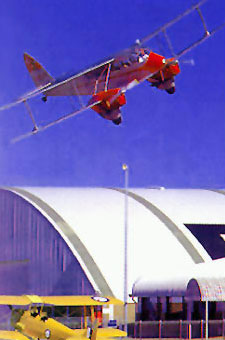
 Located 233km north-east of Melbourne, Wangarratta is the home of Airworld, The Aviation Museum. The Museum is dedicated to preserving Australia's aviation history for the benefit of future generations. Airworld is the world's largest collection of flying antique civil aircraft. The museum is owned and operated by the Rural City Of Wangaratta and features over 30 rare and 30 rare and historically significant aeroplanes as well as a large collection of antique bicycles, motorbikes and trucks.
Wangaratta was first seen by Europeans when explorers Hume and Hovell passed by in 1824 and twelve years later Major Mitchell passed on his return to Sydney. The crossing of the Ovens River at Wangaratta became the most common point for early travellers along the route from Melbourne to Sydney and a town sprang up around it. As gold was discovered in the area, notably at Beechworth in 1852, the towship became a popular crossing and the punt operator, 'Billy the Puntman' was said to have earned up to $200 a day ferrying prospectors and diggers across the river.
The gold rush also brought bushrangers to the area. Among the most notorious of these was 'Mad Dan Morgan'. His headless remains are in the Wangaratta Cemetery. Ned kelly and his gang were captured at Glenrowan just south of Wangaratta.
Today Wangaratta is a vibrant city perfectly situated for touring the many wineries of the area, taking excursions to the snowfields only an hour east, or to the Murray River just to the north.
There are many things to see and do in the town. Just east across the freeway at the airport is Drage Air Museum, housing a collection of historic planes and memorabilia which is well worth visiting. In the centre of town Merriwa Park offers plenty of room to picnic and relax in leafy surrounds, and the King George Gardens are a pleasant respite in the centre of the city.
Images and information placed above are from
www.airportsaustralia.com
We thank them for the data!
| General Info
|
| Country |
Australia
|
| ICAO ID |
YWGT
|
| Time |
UTC+10(+11DT)
|
| Latitude |
-36.415833
36° 24' 57.00" S
|
| Longitude |
146.306944
146° 18' 25.00" E
|
| Elevation |
504 feet
154 meters
|
| Magnetic Variation |
011° E (01/04)
|
| Operating Agency |
CIVIL GOVERNMENT, (LANDING FEES AND DIPLOMATIC CLEARANCE MAY BE REQUIRED)
|
| Communications
|
| MELBOURNE CNTR |
125.2
|
| CTAF |
119.1
|
| Communications Remarks |
|
| FSS |
(circuit area)
|
| Runways
|
| ID |
Dimensions |
Surface |
PCN |
ILS
|
| 09/27 |
1739 x 60 feet
530 x 18 meters |
GRASS OR EARTH NOT GRADED OR ROLLED. |
- |
NO
|
| 18/36 |
5381 x 98 feet
1640 x 30 meters |
ASPHALT |
012FBZT |
NO
|
| Navaids
|
| Type |
ID |
Name |
Channel |
Freq |
Distance From Field |
Bearing From Navaid
|
| NDB |
WGT |
WANGARATTA |
- |
203 |
At Field |
-
|
| Supplies/Equipment
|
| Fuel |
Jet A1, without icing nhibitor.
100/130 MIL Spec, low lead, aviation gasoline (BLUE)
|
| Remarks
|
| CAUTION |
Bird and animal haz. Unlit twr 1539' AMSL 259 4.4 NM fr Arpt.
|
| FUEL |
(NC-100LL) Avbl 2300-0500Z++ Mon-Fri exc hol, 1 hr PN, fone C03 57213845.
|
| LGT |
ACTIVATE-Rwy 18-36-119.2.
|
Runway 09/27
1739 x 60 feet
530 x 18 meters
| Runway 09
|
| Surface |
GRASS OR EARTH NOT GRADED OR ROLLED.
|
| True Heading |
098.0
|
| Latitude |
-36.418933
36° 25' 08.16" S
|
| Longitude |
146.299617
146° 17' 58.62" E
|
| Landing Distance |
1739 feet
530 meters
|
| Takeoff Distance |
1739 feet
530 meters
|
| Runway 27
|
| Surface |
GRASS OR EARTH NOT GRADED OR ROLLED.
|
| True Heading |
278.0
|
| Latitude |
-36.419594
36° 25' 10.54" S
|
| Longitude |
146.305508
146° 18' 19.83" E
|
| Landing Distance |
1739 feet
530 meters
|
| Takeoff Distance |
1739 feet
530 meters
|
Runway 18/36
5381 x 98 feet
1640 x 30 meters
| Runway 18
|
| Surface |
ASPHALT
|
| True Heading |
188.0
|
| Latitude |
-36.408311
36° 24' 29.92" S
|
| Longitude |
146.309672
146° 18' 34.82" E
|
| Landing Distance |
5381 feet
1640 meters
|
| Takeoff Distance |
5381 feet
1640 meters
|
| Lighting System |
PCL
LIRL |
| Runway 36
|
| Surface |
ASPHALT
|
| True Heading |
008.0
|
| Latitude |
-36.422925
36° 25' 22.53" S
|
| Longitude |
146.307056
146° 18' 25.40" E
|
| Landing Distance |
5381 feet
1640 meters
|
| Takeoff Distance |
5381 feet
1640 meters
|
| Lighting System |
PCL
LIRL |
Navaids
| WANGARATTA
|
| Type |
ID |
Channel |
Freq |
Country |
State
|
| NDB |
WGT |
- |
203 |
Australia |
-
|
| Latitude |
Longitude |
Airport
|
-36.421514
36° 25' 17.45" S |
146.304531
146° 18' 16.31" E |
YWGT
|
The content above was published at Airports-Worldwide.com in 2004-2006.
We don't guarantee the information is fresh and accurate. The data may be wrong or outdated.
For more up-to-date information please refer to other sources.
|
 |


