 |
|
|
|
|
|
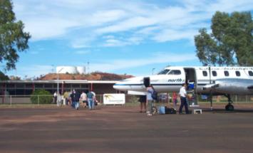 Located one kilometre from the remote outback township, the airport caters to mining companies and small predominantly aboriginal communities in the surrounding area, providing an important link for the local population with Alice Springs, Katherine, Darwin and regional centres.
Location
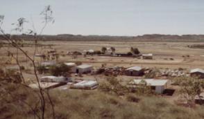
Tennant Creek is located approximately 500 kilometres north of Alice Springs in the Barkly region of the Northern Territory.
Tennant Creek Airport is bounded by Irvine Street to the south, the North Stuart Highway and Scott Street to the east and open scrub land to the west and north. The airport occupies an area of approximately 323 hectares.
Strategic Location
The geographic co-ordinates of the meteorology station, located at the airport are latitude 19 degrees 38' south and longitude 134 degrees 11' east.
History and Background
The terminal facilities at Tennant Creek Airport were constructed during the 1960's, although the airport itself was used during World War 11.
On 1 April 1989, Federal Airports Corporation took control of the airport and on 10 June 1998, passed control and management to the Airport Development Group (ADG). ADG hold a 50 year lease over Tennant Creek Airport with free option for a further 49 years.
It also has facilities for handling minor air freight. Passenger facilities at the airport include an airport terminal, luggage handling facilities and a free car park.
 Location: Irvine Street, TENNANT CREEK
Postal Address:
P O Box 35,
TENNANT CREEK, NT 0861,
AUSTRALIA
Resident Aerdrome Operator:
Dennis Windsor
Telephone No: + 61 8 8962 2894
Facsimile No: + 61 8 8962 2825
General Manager:
Don McDonald
Telephone No: +61 8 8951 1204
Facsimile No. +61 8 8955 5046
Located at Alice Springs Airport
URL: http://www.aliceairport.com.au/TCA/airport.htm
Images and information placed above are from
http://www.aliceairport.com.au/TCA/airport.htm
We thank them for the data!
| General Info
|
| Country |
Australia
|
| ICAO ID |
YTNK
|
| Time |
UTC+9:30
|
| Latitude |
-19.634444
19° 38' 04.00" S
|
| Longitude |
134.183333
134° 11' 00.00" E
|
| Elevation |
1236 feet
377 meters
|
| Magnetic Variation |
005° E (01/04)
|
| Beacon |
Yes
|
| Operating Agency |
CIVIL GOVERNMENT, (LANDING FEES AND DIPLOMATIC CLEARANCE MAY BE REQUIRED)
|
| Communications
|
| BRISBANE CNTR |
122.1
|
| CTAF |
126.7
|
| Communications Remarks |
|
| FSS |
(On gnd)
|
| Runways
|
| ID |
Dimensions |
Surface |
PCN |
ILS
|
| 07/25 |
6427 x 98 feet
1959 x 30 meters |
ASPHALT |
017FBZT |
NO
|
| 11/29 |
3468 x 59 feet
1057 x 18 meters |
ASPHALT |
017FBZT |
NO
|
| Navaids
|
| Type |
ID |
Name |
Channel |
Freq |
Distance From Field |
Bearing From Navaid
|
| VOR-DME |
TNK |
TENNANT CREEK |
076X |
112.9 |
At Field |
-
|
| NDB |
TNK |
TENNANT CREEK |
- |
272 |
At Field |
-
|
| Supplies/Equipment
|
| Fuel |
Jet A1, without icing nhibitor.
100/130 MIL Spec, low lead, aviation gasoline (BLUE)
|
| Remarks
|
| CAUTION |
Haz bcn 1563' 089 2 NM fr fld. Bird and animal haz.
|
| FUEL |
Avbl 2230-0730Z Mon-Fri, fone C08-8962-2696. (NC-100LL, A1)
|
| LGT |
ACTIVATE-Rwys 07-25 and 11-29 lgt and VASI-120.6. Portable lgt PN.
|
| MISC |
Ldg fees
|
| RSTD |
PPR for non reg sked acft abv 12,500 lbs, fone 08 8951 1211. Acft abv GWT 33,000lb must use rwy ends for 18 turns.
|
Runway 07/25
6427 x 98 feet
1959 x 30 meters
| Runway 07
|
| Surface |
ASPHALT
|
| True Heading |
073.0
|
| Latitude |
-19.641111
19° 38' 28.00" S
|
| Longitude |
134.167769
134° 10' 03.97" E
|
| Elevation |
1204.0 feet
367 meters
|
| Slope |
0.4°
|
| Landing Distance |
6427 feet
1959 meters
|
| Takeoff Distance |
6427 feet
1959 meters
|
| Lighting System |
PCL
LIRL
VA
PORTABLE |
| Runway 25
|
| Surface |
ASPHALT
|
| True Heading |
253.0
|
| Latitude |
-19.636111
19° 38' 10.00" S
|
| Longitude |
134.185561
134° 11' 08.02" E
|
| Elevation |
1229.0 feet
375 meters
|
| Slope |
-0.4°
|
| Landing Distance |
6427 feet
1959 meters
|
| Takeoff Distance |
6427 feet
1959 meters
|
| Lighting System |
PCL
LIRL
VA
PORTABLE |
Runway 11/29
3468 x 59 feet
1057 x 18 meters
| Runway 11
|
| Surface |
ASPHALT
|
| True Heading |
119.0
|
| Latitude |
-19.634050
19° 38' 02.58" S
|
| Longitude |
134.176431
134° 10' 35.15" E
|
| Elevation |
1211.0 feet
369 meters
|
| Slope |
0.3°
|
| Landing Distance |
3468 feet
1057 meters
|
| Takeoff Distance |
3468 feet
1057 meters
|
| Lighting System |
PCL
LIRL
PORTABLE |
| Runway 29
|
| Surface |
ASPHALT
|
| True Heading |
299.0
|
| Latitude |
-19.638717
19° 38' 19.38" S
|
| Longitude |
134.185228
134° 11' 06.82" E
|
| Elevation |
1222.0 feet
372 meters
|
| Slope |
-0.3°
|
| Landing Distance |
3468 feet
1057 meters
|
| Takeoff Distance |
3468 feet
1057 meters
|
| Lighting System |
PCL
LIRL
PORTABLE |
Navaids
| TENNANT CREEK
|
| Type |
ID |
Channel |
Freq |
Country |
State
|
| NDB |
TNK |
- |
272 |
Australia |
-
|
| Latitude |
Longitude |
Airport
|
-19.644167
19° 38' 39.00" S |
134.175278
134° 10' 31.00" E |
YTNK
|
| TENNANT CREEK
|
| Type |
ID |
Channel |
Freq |
Country |
State
|
| VOR-DME |
TNK |
076X |
112.9 |
Australia |
-
|
| Latitude |
Longitude |
Airport
|
-19.634444
19° 38' 04.00" S |
134.181389
134° 10' 53.00" E |
YTNK
|
The content above was published at Airports-Worldwide.com in 2004-2006.
We don't guarantee the information is fresh and accurate. The data may be wrong or outdated.
For more up-to-date information please refer to other sources.
|
 |


