|
|
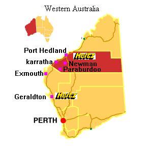
Port Headland International Airport |
 Operator: Port Healand International Airport
Address:
PO Box 271
Port Headland WA 6721
Australia
Phone: +61 8 91401288
Fax: +61 8 91722074
E-mail: jennybrough at houghtons com au
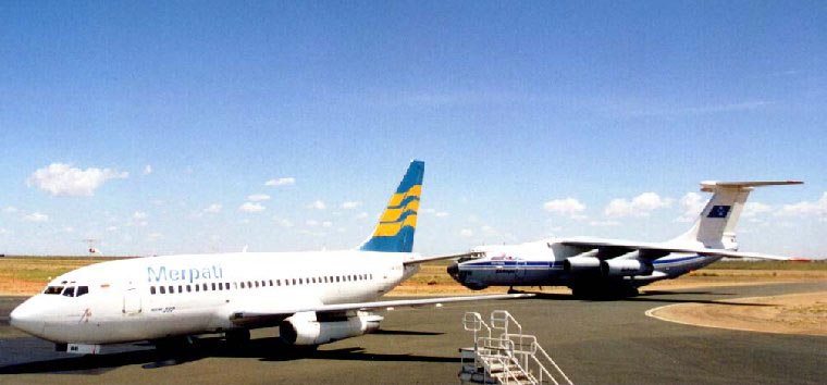
 Located 9km from Port Headland provides International connections
to Indonesia. Its internationally competitive facilities, which include
separate international and domestic departure lounges, are used by a wide
range of light, commercial and military aircraft. Regular carriers into
the airport includes Ansett Australia and Indonesia's Merpati Nusantara
Airlines, Pearl Aviation, Golden Eagle Airlines and Polar Aviation. The
airport also provides a range of local services including several car
hire operations which offer a 24 hour service and three air charter companies
which fly to all points within the region.
Located 9km from Port Headland provides International connections
to Indonesia. Its internationally competitive facilities, which include
separate international and domestic departure lounges, are used by a wide
range of light, commercial and military aircraft. Regular carriers into
the airport includes Ansett Australia and Indonesia's Merpati Nusantara
Airlines, Pearl Aviation, Golden Eagle Airlines and Polar Aviation. The
airport also provides a range of local services including several car
hire operations which offer a 24 hour service and three air charter companies
which fly to all points within the region.
|
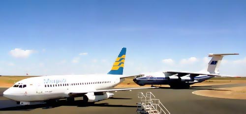 |
Photo credit: Doug Whitfield
(Click on the photo to enlarge)
|
|
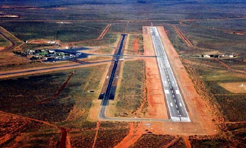 |
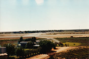
Photo credit: Doug Whitfield
(Click on the photo to enlarge)
|
Images and information placed above are from
http://www.flightclub com au/wa-airstrips/porthedland/
www.airportsaustralia.com
We thank them for the data!
| General Info
|
| Country |
Australia
|
| ICAO ID |
YPPD
|
| Time |
UTC+8
|
| Latitude |
-20.377778
20° 22' 40.00" S
|
| Longitude |
118.626389
118° 37' 35.00" E
|
| Elevation |
33 feet
10 meters
|
| Type |
Civil
|
| Magnetic Variation |
001° E (01/04)
|
| Beacon |
Yes
|
| Operating Agency |
CIVIL GOVERNMENT, (LANDING FEES AND DIPLOMATIC CLEARANCE MAY BE REQUIRED)
|
| International Clearance Status |
Airport of Entry
|
| Communications
|
| MTAF |
119.9
|
| MELBOURNE CNTR |
118.6
|
| Communications Remarks |
|
| MISC |
(Nstd 30 NM rad to 10,000')
|
| FSS |
(on gnd)
|
| Runways
|
| ID |
Dimensions |
Surface |
PCN |
ILS
|
| 14/32 |
8202 x 148 feet
2500 x 45 meters |
ASPHALT |
039FAXT |
NO
|
| 18/36 |
3281 x 59 feet
1000 x 18 meters |
ASPHALT |
008FAYU |
NO
|
| Navaids
|
| Type |
ID |
Name |
Channel |
Freq |
Distance From Field |
Bearing From Navaid
|
| VOR-DME |
PD |
PORT HEDLAND |
088X |
114.1 |
At Field |
-
|
| NDB |
PD |
PORT HEDLAND |
- |
260 |
1.1 NM |
305.1
|
| Supplies/Equipment
|
| Fuel |
Jet A1, without icing nhibitor.
100/130 MIL Spec, low lead, aviation gasoline (BLUE)
|
| Oil |
O-117, 1100, Reciprocating Engine Oil (MIL L 6082)
|
| Remarks
|
| CAUTION |
Bird and animal haz. Unlgtd mast 224' AGL, 222 , 2.6 NM fr fld.
|
| CSTMS/IMG |
Avbl PN rqr.
|
| FUEL |
Avbl 2330-1100Z Mon-Fri; OT 30 min PN. Phone C08 9172 1836. (NC-100LL, A1)
|
| LGT |
ACTIVATE-Rwy 14-32 and T-VASI - 119.9 . Arpt bcn avbl on req, fone C0417 108 850.
|
| MISC |
Ldg fees. Arpt opr fone C08 9140 1288.
|
| OIL |
O-117.
|
| RSTD |
All turns use turning nodes, max rad and min speed.
|
Runway 14/32
8202 x 148 feet
2500 x 45 meters
| Runway 14
|
| Surface |
ASPHALT
|
| True Heading |
137.0
|
| Latitude |
-20.374086
20° 22' 26.71" S
|
| Longitude |
118.621600
118° 37' 17.76" E
|
| Elevation |
23.0 feet
7 meters
|
| Slope |
0.1°
|
| Landing Distance |
8202 feet
2500 meters
|
| Takeoff Distance |
8202 feet
2500 meters
|
| Lighting System |
PCL
LIRL
VA |
| Runway 32
|
| Surface |
ASPHALT
|
| True Heading |
317.0
|
| Latitude |
-20.390717
20° 23' 26.58" S
|
| Longitude |
118.637800
118° 38' 16.08" E
|
| Elevation |
33.0 feet
10 meters
|
| Slope |
-0.1°
|
| Landing Distance |
8202 feet
2500 meters
|
| Takeoff Distance |
8202 feet
2500 meters
|
| Lighting System |
PCL
LIRL
VA |
Runway 18/36
3281 x 59 feet
1000 x 18 meters
| Runway 18
|
| Surface |
ASPHALT
|
| True Heading |
182.0
|
| Latitude |
-20.370286
20° 22' 13.03" S
|
| Longitude |
118.629294
118° 37' 45.46" E
|
| Elevation |
27.0 feet
8 meters
|
| Slope |
0.1°
|
| Landing Distance |
3281 feet
1000 meters
|
| Takeoff Distance |
3281 feet
1000 meters
|
| Runway 36
|
| Surface |
ASPHALT
|
| True Heading |
002.0
|
| Latitude |
-20.379303
20° 22' 45.49" S
|
| Longitude |
118.628892
118° 37' 44.01" E
|
| Elevation |
29.0 feet
9 meters
|
| Slope |
-0.1°
|
| Landing Distance |
3281 feet
1000 meters
|
| Takeoff Distance |
3281 feet
1000 meters
|
Navaids
| PORT HEDLAND
|
| Type |
ID |
Channel |
Freq |
Country |
State
|
| NDB |
PD |
- |
260 |
Australia |
-
|
| Latitude |
Longitude |
Airport
|
-20.389167
20° 23' 21.00" S |
118.642500
118° 38' 33.00" E |
YPPD
|
| PORT HEDLAND
|
| Type |
ID |
Channel |
Freq |
Country |
State
|
| VOR-DME |
PD |
088X |
114.1 |
Australia |
-
|
| Latitude |
Longitude |
Airport
|
-20.378333
20° 22' 42.00" S |
118.622778
118° 37' 22.00" E |
YPPD
|
The content above was published at Airports-Worldwide.com in 2004-2006.
We don't guarantee the information is fresh and accurate. The data may be wrong or outdated.
For more up-to-date information please refer to other sources.
|
 |