 |
|
|
|
|
|
 Operator: Parkes Shire Council
Address:
PO Box 337
Parkes NSW 2870
Australia
Phone: +61 68612333
Fax: +61 2 68623946
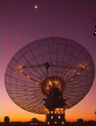
Parkes most famous land mark is man made, the CSIRO Radio Telescope is located 25kms north of town on the Newell Highway. The CSIRO Astronomy Education and Visitors Centre features attractive displays, interactive exhibits, a relaxed reading environment of historical and contemporary information, education materials and souvenirs.
Airport Redevelopment Project overview
Parkes is a strategic and expanding inland freight transit location at the intersection of national highway and rail corridors (Sydney-Perth and inland Brisbane-Melbourne). It is also considered the best location in eastern Australia (outside of the capital cities) for a new jet airport for 24-hour passenger and air freight operations - with an adjoining large-scale Logistics precinct - spread over more than 1,000 ha?2,470 acres.
The Project encompasses the expanding Airport as an anchor tenant to provide air freight and aviation engineering uses, co-located with the planned large scale Logistics and Light Industrial User Precinct leveraging the regions existing transport infrastructure (5 highways and the existing east-west and future north-south inland rail line).
 A variety of attractive incentives are available for the relocation of aviation, logistics, agri-food related light industry and other uses to Parkes Airport and Parkes Terminal. Enquiries are now being received via the "contact us" page.
Council operates a licenced airport at Parkes and grassed airstrips at Peak Hill, Trundle and Tullamore.
The Parkes Airport is well serviced by regular public transport (RPT), and has an Aero Club, a Training School, an aircraft maintenance business, and a refuelling agent, operating on the grounds.
Approximately 15,000 passengers pass through Parkes Airport each year.
Airport
Stage 3 of the Parkes Airport Redevelopment involves runway expansion with an upgraded Category 1 jet aircraft runway (initially approx. 3,200m although existing consent applies for expansion up to 3,800m), new aprons, new taxi-ways, aviation and general purpose fuel farm, air freight terminal and aviation engineering development.
URL: Parkes Airport
Images and information placed above are from
Parkes Airport
We thank them for the data!
| General Info
|
| Country |
Australia
|
| ICAO ID |
YPKS
|
| Time |
UTC+10(+11DT)
|
| Latitude |
-33.131389
33° 07' 53.00" S
|
| Longitude |
148.239167
148° 14' 21.00" E
|
| Elevation |
1069 feet
326 meters
|
| Magnetic Variation |
011° E (01/04)
|
| Operating Agency |
CIVIL GOVERNMENT, (LANDING FEES AND DIPLOMATIC CLEARANCE MAY BE REQUIRED)
|
| Communications
|
| MELBOURNE CNTR |
135.25
|
| CTAF |
126.7
|
| Communications Remarks |
|
| FSS |
(circuit area)
|
| Runways
|
| ID |
Dimensions |
Surface |
PCN |
ILS
|
| 04/22 |
5525 x 148 feet
1684 x 45 meters |
ASPHALT |
011FCZU |
NO
|
| 11/29 |
5322 x 98 feet
1622 x 30 meters |
ASPHALT |
011FCZU |
NO
|
| Navaids
|
| Type |
ID |
Name |
Channel |
Freq |
Distance From Field |
Bearing From Navaid
|
| VOR-DME |
PKS |
PARKES |
057X |
112 |
At Field |
-
|
| NDB |
PKS |
PARKES |
- |
242 |
1.1 NM |
309.7
|
| Supplies/Equipment
|
| Fuel |
Jet A1, without icing nhibitor.
100/130 MIL Spec, low lead, aviation gasoline (BLUE)
|
| Oil |
O-156, MIL L 23699 (Synthetic Base)Turboprop/Turboshaft Engine
|
| Remarks
|
| FUEL |
(NC-100LL, A1)
|
| LGT |
ACTIVATE-Rwy 04-22-119.6. Portable lgt PN.
|
| MISC |
Ldg fees.
|
| OIL |
O-156
|
Runway 04/22
5525 x 148 feet
1684 x 45 meters
| Runway 04
|
| Surface |
ASPHALT
|
| True Heading |
055.0
|
| Latitude |
-33.137244
33° 08' 14.08" S
|
| Longitude |
148.230578
148° 13' 50.08" E
|
| Elevation |
1029.0 feet
314 meters
|
| Slope |
0.7°
|
| Landing Distance |
5525 feet
1684 meters
|
| Takeoff Distance |
5525 feet
1684 meters
|
| Lighting System |
PCL
LIRL
PORTABLE |
| Runway 22
|
| Surface |
ASPHALT
|
| True Heading |
235.0
|
| Latitude |
-33.128522
33° 07' 42.68" S
|
| Longitude |
148.245331
148° 14' 43.19" E
|
| Elevation |
1067.0 feet
325 meters
|
| Slope |
-0.7°
|
| Landing Distance |
5525 feet
1684 meters
|
| Takeoff Distance |
5525 feet
1684 meters
|
| Lighting System |
PCL
LIRL
PORTABLE |
Runway 11/29
5322 x 98 feet
1622 x 30 meters
| Runway 11
|
| Surface |
ASPHALT
|
| True Heading |
125.0
|
| Latitude |
-33.124806
33° 07' 29.30" S
|
| Longitude |
148.230289
148° 13' 49.04" E
|
| Elevation |
1033.0 feet
315 meters
|
| Slope |
0.7°
|
| Landing Distance |
5322 feet
1622 meters
|
| Takeoff Distance |
5322 feet
1622 meters
|
| Lighting System |
PORTABLE
|
| Runway 29
|
| Surface |
ASPHALT
|
| True Heading |
305.0
|
| Latitude |
-33.133181
33° 07' 59.45" S
|
| Longitude |
148.244600
148° 14' 40.56" E
|
| Elevation |
1069.0 feet
326 meters
|
| Slope |
-0.7°
|
| Landing Distance |
4754 feet
1449 meters
|
| Takeoff Distance |
5322 feet
1622 meters
|
| Displaced Threshold Length |
568 feet
173 meters
|
| Lighting System |
PORTABLE
|
Navaids
| PARKES
|
| Type |
ID |
Channel |
Freq |
Country |
State
|
| NDB |
PKS |
- |
242 |
Australia |
-
|
| Latitude |
Longitude |
Airport
|
-33.145278
33° 08' 43.00" S |
148.252500
148° 15' 09.00" E |
YPKS
|
| PARKES
|
| Type |
ID |
Channel |
Freq |
Country |
State
|
| VOR-DME |
PKS |
057X |
112 |
Australia |
-
|
| Latitude |
Longitude |
Airport
|
-33.131111
33° 07' 52.00" S |
148.237222
148° 14' 14.00" E |
YPKS
|
The content above was published at Airports-Worldwide.com in 2004-2006.
We don't guarantee the information is fresh and accurate. The data may be wrong or outdated.
For more up-to-date information please refer to other sources.
|
 |


