 |
|
 Operator: Northwest travel Services Pty Ltd
Address: PO Box 1
Paraburdoo WA 6754
Australia
Phone: +61 8 91896044
Fax: +61 8 91895525
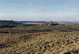
Paraburdoo was derived from the Aboriginal name "Piru-Pardu" which literally means 'meat feathers'. Aboriginals used this name because of the abundance of white cockatoos in the area. Iron ore is the local industry. The ore is mined by Hamersley Iron Pty Ltd and is transported by rail to the company's port at Dampier. From there it is shipped to Europe, Japan, China and other Asian countries. The airport is located 9km from the town centre.
Images and information placed above are from
www.airportsaustralia.com
We thank them for the data!
| General Info
|
| Country |
Australia
|
| ICAO ID |
YPBO
|
| Time |
UTC+8
|
| Latitude |
-23.171111
23° 10' 16.00" S
|
| Longitude |
117.745278
117° 44' 43.00" E
|
| Elevation |
1406 feet
429 meters
|
| Magnetic Variation |
001° E (01/04)
|
| Operating Agency |
CIVIL GOVERNMENT, (LANDING FEES AND DIPLOMATIC CLEARANCE MAY BE REQUIRED)
|
| Communications
|
| MTAF |
126.7
|
| MELBOURNE CNTR |
125.7
|
| Communications Remarks |
|
| FSS |
(on gnd)
|
| Runways
|
| ID |
Dimensions |
Surface |
PCN |
ILS
|
| 06/24 |
6995 x 148 feet
2132 x 45 meters |
ASPHALT |
030FCXU |
NO
|
| Navaids
|
| Type |
ID |
Name |
Channel |
Freq |
Distance From Field |
Bearing From Navaid
|
| VOR-DME |
PBO |
PARABURDOO |
116X |
116.9 |
At Field |
-
|
| NDB |
PBO |
PARABURDOO |
- |
278 |
At Field |
-
|
| Supplies/Equipment
|
| Fuel |
Jet A1, without icing nhibitor.
100/130 MIL Spec, low lead, aviation gasoline (BLUE)
|
| Remarks
|
| CAUTION |
Bird haz. Blasting at mine site 240 , 8 NM fr arpt.
|
| FUEL |
Avbl 0001-1000Z Mon-Fri; 0001-0400Z Sat. (NC-100LL, A1). Fone C08 9189 5016.
|
| LGT |
ACTIVATE-Rwy 06-24, 120.6 Rng rstd in some sctr at MSA.
|
| RSTD |
Acft abv 12,500 lb to turn at rwy ends only.
|
| TFC PAT |
Rwy 24 rgt circuits only.
|
Runway 06/24
6995 x 148 feet
2132 x 45 meters
| Runway 06
|
| Surface |
ASPHALT
|
| True Heading |
065.0
|
| Latitude |
-23.175453
23° 10' 31.63" S
|
| Longitude |
117.737478
117° 44' 14.92" E
|
| Elevation |
1374.0 feet
419 meters
|
| Slope |
0.4°
|
| Landing Distance |
6995 feet
2132 meters
|
| Takeoff Distance |
6995 feet
2132 meters
|
| Lighting System |
PCL
LIRL
VA
PORTABLE |
| Runway 24
|
| Surface |
ASPHALT
|
| True Heading |
245.0
|
| Latitude |
-23.167372
23° 10' 02.54" S
|
| Longitude |
117.756381
117° 45' 22.97" E
|
| Elevation |
1405.0 feet
428 meters
|
| Slope |
-0.4°
|
| Landing Distance |
6995 feet
2132 meters
|
| Takeoff Distance |
6995 feet
2132 meters
|
| Lighting System |
PCL
LIRL
VA
PORTABLE |
Navaids
| PARABURDOO
|
| Type |
ID |
Channel |
Freq |
Country |
State
|
| NDB |
PBO |
- |
278 |
Australia |
-
|
| Latitude |
Longitude |
Airport
|
-23.178889
23° 10' 44.00" S |
117.742500
117° 44' 33.00" E |
YPBO
|
| PARABURDOO
|
| Type |
ID |
Channel |
Freq |
Country |
State
|
| VOR-DME |
PBO |
116X |
116.9 |
Australia |
-
|
| Latitude |
Longitude |
Airport
|
-23.172500
23° 10' 21.00" S |
117.736944
117° 44' 13.00" E |
YPBO
|
The content above was published at Airports-Worldwide.com in 2004-2006.
We don't guarantee the information is fresh and accurate. The data may be wrong or outdated.
For more up-to-date information please refer to other sources.
|
 |


