 |
|
 Operator: Narromine Shire Council
Address:
PO Box 115
Narromine NSW 2821
Australia
Narromine Shire Tourist Centre: 02 6889 9980
Fax: 02 6889 9988
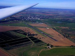 Narromine is situated in the midst of rich farming, irrigation and grazing
country in central New South Wales, Australia. Narromine offers excellent
opportunities for fishing, waterskiing and other water sports on the Macquarie
River which flows past the town. It also has the one of the best gliding
areas in the world. The airport is just 1.8km from the town centre.
Narromine is situated in the midst of rich farming, irrigation and grazing
country in central New South Wales, Australia. Narromine offers excellent
opportunities for fishing, waterskiing and other water sports on the Macquarie
River which flows past the town. It also has the one of the best gliding
areas in the world. The airport is just 1.8km from the town centre.
Narromine lies on the banks of the Macquarie River, surrounded by countryside
devoted to pastoralism and wheat. The land is also irrigated for the cultivation
of cotton, citrus fruit, sorghum and vegetables. William Charles Wentworth
(famous as one of the explorers who crossed the Blue Mountains) and Thomas
Raine occupied land and established a station here in 1840. The town was
eventually laid out just before the railway arrived in 1882.
Narromine was an air force training base during World War II and is well
known to flying and gliding enthusiasts. The airport at Narromine has
been developed to international standards and is the home of the oldest
aero club in Australia.
The National Trust listed courthouse is now the local Museum where the
area's history is on display. Swane's Rose and Fruit Tree Nursery and
Gin Gin Weir are of interest.
Images and information placed above are from
www.airportsaustralia.com
We thank them for the data!
| General Info
|
| Country |
Australia
|
| ICAO ID |
YNRM
|
| Time |
UTC+10(+11DT)
|
| Latitude |
-32.214722
32° 12' 53.00" S
|
| Longitude |
148.225000
148° 13' 30.00" E
|
| Elevation |
782 feet
238 meters
|
| Magnetic Variation |
011° E (01/04)
|
| Beacon |
Yes
|
| Operating Agency |
CIVIL GOVERNMENT, (LANDING FEES AND DIPLOMATIC CLEARANCE MAY BE REQUIRED)
|
| Communications
|
| MELBOURNE CNTR |
123.9
|
| CTAF |
126.7
|
| Communications Remarks |
|
| FSS |
(circuit area)
|
| Runways
|
| ID |
Dimensions |
Surface |
PCN |
ILS
|
| 04/22 |
3609 x 148 feet
1100 x 45 meters |
ASPHALT |
010FBZT |
NO
|
| 11/29 |
4990 x 98 feet
1521 x 30 meters |
ASPHALT |
010FBZT |
NO
|
| Navaids
|
| Type |
ID |
Name |
Channel |
Freq |
Distance From Field |
Bearing From Navaid
|
| NDB |
NRM |
NARROMINE |
- |
215 |
At Field |
-
|
| Supplies/Equipment
|
| Fuel |
100/130 MIL Spec, low lead, aviation gasoline (BLUE)
|
| Oil |
O-117, 1100, Reciprocating Engine Oil (MIL L 6082)
O-128, 1100,(Dispersant)Reciprocating Engine Oil(MIL L 22851 Type II)
|
| JASU |
|
| Remarks
|
| CAUTION |
Glider opr SR-SS wkend and pub hol.
|
| FLUID |
H515
|
| FUEL |
(NC-100LL)
|
| JASU |
1(E1)
|
| LGT |
ACTIVATE-Rwy 11-29-122.4.
|
| OIL |
O-117-128
|
Runway 04/22
3609 x 148 feet
1100 x 45 meters
| Runway 04
|
| Surface |
ASPHALT
|
| True Heading |
054.0
|
| Latitude |
-32.218433
32° 13' 06.36" S
|
| Longitude |
148.220894
148° 13' 15.22" E
|
| Elevation |
780.0 feet
238 meters
|
| Slope |
0.0°
|
| Landing Distance |
3609 feet
1100 meters
|
| Takeoff Distance |
3609 feet
1100 meters
|
| Runway 22
|
| Surface |
ASPHALT
|
| True Heading |
234.0
|
| Latitude |
-32.212575
32° 12' 45.27" S
|
| Longitude |
148.230308
148° 13' 49.11" E
|
| Elevation |
781.0 feet
238 meters
|
| Slope |
0.0°
|
| Landing Distance |
3609 feet
1100 meters
|
| Takeoff Distance |
3609 feet
1100 meters
|
Runway 11/29
4990 x 98 feet
1521 x 30 meters
| Runway 11
|
| Surface |
ASPHALT
|
| True Heading |
121.0
|
| Latitude |
-32.212319
32° 12' 44.35" S
|
| Longitude |
148.217683
148° 13' 03.66" E
|
| Elevation |
776.0 feet
237 meters
|
| Slope |
0.1°
|
| Landing Distance |
4990 feet
1521 meters
|
| Takeoff Distance |
4990 feet
1521 meters
|
| Lighting System |
PCL
LIRL |
| Runway 29
|
| Surface |
ASPHALT
|
| True Heading |
301.0
|
| Latitude |
-32.219458
32° 13' 10.05" S
|
| Longitude |
148.231453
148° 13' 53.23" E
|
| Elevation |
782.0 feet
238 meters
|
| Slope |
-0.1°
|
| Landing Distance |
4144 feet
1263 meters
|
| Takeoff Distance |
4990 feet
1521 meters
|
| Displaced Threshold Length |
846 feet
258 meters
|
| Lighting System |
PCL
LIRL |
Navaids
| NARROMINE
|
| Type |
ID |
Channel |
Freq |
Country |
State
|
| NDB |
NRM |
- |
215 |
Australia |
-
|
| Latitude |
Longitude |
Airport
|
-32.223089
32° 13' 23.12" S |
148.229211
148° 13' 45.16" E |
YNRM
|
The content above was published at Airports-Worldwide.com in 2004-2006.
We don't guarantee the information is fresh and accurate. The data may be wrong or outdated.
For more up-to-date information please refer to other sources.
|
 |


