 |
|
|
|
|
|
 Operator: Australian Airports (Mount Isa) Pty Ltd
Address:
PO Box 2305
Mount Isa QLD 4825
Australia
Phone: +61 7 47434598
Fax: +61 7 47430999
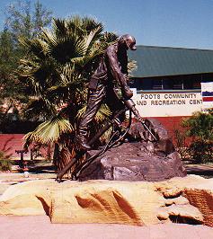 Surrounded by the beautiful Selwyn Ranges, Mount Isa is the mining, industrial and commercial capital of Northwest Queensland, Australia. This picture beside the Riversleigh Fossil Centre, commemorates Miners who suffered and endured the hardships from mining in the early days. The airport is located 7.5km from the town centre.
A thriving inland city set amidst landscapes of the Selwyn Ranges, Mount Isa offers visitors a wide variety of things to see and do. From Australia's ancient past rebuilt at the multi-award-winning Riversleigh Fossil Museum (just one of the attractions at the new AUD12 million Outback at Isa Complex) to one of the world's most modern mining operations at the popular Mount Isa Mines, the city's attractions are numerous. Other popular venues and activities include Hard Times Mine, Sir James Foots Gallery, Outback Park, Royal Flying Doctor Service Base, School of the Air, National Trust Tent House, Underground Hospital and Beth Anderson Museum and fishing for barramundi at Lake Moondarra.
Mount Isa's existence and its main financial base is the huge Mount Isa Mine, the world's largest single producer of copper, silver, lead and zinc. In 1923, John Campbell Miles found a silver-lead ore outcrop and sent a sample to Cloncurry to be assessed. Miles pegged two leases and soon 500 were filled. Mount Isa Mines took over operations in 1924. This rich deposit is still producing high volumes of ore and is classed as one of the world's great mines.
Considered by many as the capital of north-west Queensland, Mount Isa also boasts a great range of shopping facilities. 'The Isa' as it is know by locals, is also an ideal place to have mechanical repairs attended to and to stock up on supplies.
Images and information placed above are from
www.airportsaustralia.com
We thank them for the data!
| General Info
|
| Country |
Australia
|
| ICAO ID |
YBMA
|
| Time |
UTC+10
|
| Latitude |
-20.663889
20° 39' 50.00" S
|
| Longitude |
139.488611
139° 29' 19.00" E
|
| Elevation |
1121 feet
342 meters
|
| Magnetic Variation |
006° E (01/04)
|
| Beacon |
Yes
|
| Operating Agency |
CIVIL GOVERNMENT, (LANDING FEES AND DIPLOMATIC CLEARANCE MAY BE REQUIRED)
|
| Communications
|
| MTAF |
126.5
|
| BRISBANE CNTR |
122.4
|
| Communications Remarks |
|
| FSS |
(on gnd)
|
| Runways
|
| ID |
Dimensions |
Surface |
PCN |
ILS
|
12/30
CLOSED |
2802 x 59 feet
854 x 18 meters |
GRAVEL. |
- |
NO
|
| 16/34 |
8399 x 148 feet
2560 x 45 meters |
ASPHALT |
034FAXU |
NO
|
| Navaids
|
| Type |
ID |
Name |
Channel |
Freq |
Distance From Field |
Bearing From Navaid
|
| VOR-DME |
MA |
MOUNT ISA |
122X |
117.5 |
At Field |
-
|
| NDB |
MA |
MOUNT ISA |
- |
338 |
At Field |
-
|
| Supplies/Equipment
|
| Fuel |
Jet A1, without icing nhibitor.
100/130 MIL Spec, low lead, aviation gasoline (BLUE)
|
| Oil |
O-117, 1100, Reciprocating Engine Oil (MIL L 6082)
|
| Remarks
|
| CAUTION |
Blasting wi 6 NM rad, to 2500'. Bird and animal haz.
|
| FUEL |
Fone C07-4743-4843. (NC-100LL, A1)
|
| LGT |
ACTIVATE-Rwy 16-34-126.5.
|
| MISC |
Rwy 16-34 grooved.
|
| NS ABTMT |
See FLIP PLANNING AP/3.
|
| OIL |
O-117.
|
| RSTD |
PPR for prk of acft abv GWT 12,500 lb.
|
| TFC PAT |
Rwy 30 and 34 rgt tfc only.
|
Runway 16/34
8399 x 148 feet
2560 x 45 meters
| Runway 16
|
| Surface |
ASPHALT
|
| True Heading |
167.0
|
| Latitude |
-20.655042
20° 39' 18.15" S
|
| Longitude |
139.485881
139° 29' 09.17" E
|
| Elevation |
1111.0 feet
339 meters
|
| Slope |
0.0°
|
| Landing Distance |
8399 feet
2560 meters
|
| Takeoff Distance |
8399 feet
2560 meters
|
| Lighting System |
PCL
LIRL
PAPI |
| Runway 34
|
| Surface |
ASPHALT
|
| True Heading |
347.0
|
| Latitude |
-20.677642
20° 40' 39.51" S
|
| Longitude |
139.491103
139° 29' 27.97" E
|
| Elevation |
1115.0 feet
340 meters
|
| Slope |
0.0°
|
| Landing Distance |
8399 feet
2560 meters
|
| Takeoff Distance |
8399 feet
2560 meters
|
| Lighting System |
PCL
LIRL
PAPI |
Navaids
| MOUNT ISA
|
| Type |
ID |
Channel |
Freq |
Country |
State
|
| NDB |
MA |
- |
338 |
Australia |
-
|
| Latitude |
Longitude |
Airport
|
-20.675278
20° 40' 31.00" S |
139.486667
139° 29' 12.00" E |
YBMA
|
| MOUNT ISA
|
| Type |
ID |
Channel |
Freq |
Country |
State
|
| VOR-DME |
MA |
122X |
117.5 |
Australia |
-
|
| Latitude |
Longitude |
Airport
|
-20.664722
20° 39' 53.00" S |
139.485833
139° 29' 09.00" E |
YBMA
|
The content above was published at Airports-Worldwide.com in 2004-2006.
We don't guarantee the information is fresh and accurate. The data may be wrong or outdated.
For more up-to-date information please refer to other sources.
|
 |


