 |
|
|
|
|
|
 Operator: District Council of Grant
Address:
PO Box 724
Mount Gambier SA 5290
Australia
Phone: +61 8 87251112
Fax: +61 8 87232771
Mount Gambier has a Domestic airport located just north of the town, and regular flights are operated by Regional Express (Rex) Airlines and O`Connor Airlines from Adelaide to Melbourne.
The closest International airport is located in either Adelaide or Melbourne.
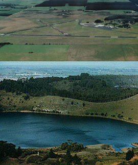 Mount Gambier, a volcanic complex of maar volcanoes, formed about 4,900 years ago making it the youngest group of volcanoes on the continent of Australia. This photo shows Blue Lake Crater, a maar volcano. The Airport is located 8.5km from the town centre.
The South-east of South Australia is noted for the limestone caves and sink-holes which form the sub-structure. In Mount Gambier there are several, easily accessible examples of caves. The easiest to find is Cave Gardens, right in the centre of town in the park opposite the Post Office. This scenic area has been landscaped around the main cave which was the site of early development in the town after the Henty brothers arrived in 1841. It was at one time the water supply for the town and windlasses were used to draw water from the base. In the 1890's a beautification scheme saw the beginnings of the gardens, and in 1909 the rose-gardens were planted. The fountain in the park was constructed in 1884.
Umpherston Cave, just east of the city on the Princes Highway, is named after James Umpherston, who arrived in 1860, and was a foundation member of the Show Society and lived on a property nearby. An interesting display on the steps leading into the cave explains its colourful history, and a Mack logging truck and an old bull-dozer are among logging displays in the beautiful gardens surrounding it.
Images and information placed above are from
www.airportsaustralia.com
We thank them for the data!
| General Info
|
| Country |
Australia
|
| ICAO ID |
YMTG
|
| Time |
UTC+9:30(+10:30DT)
|
| Latitude |
-37.745556
37° 44' 44.00" S
|
| Longitude |
140.785278
140° 47' 07.00" E
|
| Elevation |
212 feet
65 meters
|
| Magnetic Variation |
009° E (01/04)
|
| Operating Agency |
CIVIL GOVERNMENT, (LANDING FEES AND DIPLOMATIC CLEARANCE MAY BE REQUIRED)
|
| Communications
|
| MTAF |
126.65
|
| MELBOURNE CNTR |
125.8
|
| Communications Remarks |
|
| FSS |
(on gnd)
|
| Runways
|
| ID |
Dimensions |
Surface |
PCN |
ILS
|
| 06/24 |
2776 x 98 feet
846 x 30 meters |
ASPHALT |
006FAZT |
NO
|
| 11/29 |
3025 x 98 feet
922 x 30 meters |
ASPHALT |
006FAZT |
NO
|
| 18/36 |
5000 x 98 feet
1524 x 30 meters |
ASPHALT |
006FAZU |
NO
|
| Navaids
|
| Type |
ID |
Name |
Channel |
Freq |
Distance From Field |
Bearing From Navaid
|
| VOR |
MTG |
MOUNT GAMBIER |
- |
117 |
At Field |
-
|
| NDB |
MTG |
MOUNT GAMBIER |
- |
266 |
At Field |
-
|
| Supplies/Equipment
|
| Fuel |
Jet A1, without icing nhibitor.
100/130 MIL Spec, low lead, aviation gasoline (BLUE)
|
| Remarks
|
| FUEL |
Avbl 2230-0730Z++Mon-Fri, fone C08 87252595. (NC-100LL, A1)
|
| LGT |
ACTIVATE-Rwys 18-36, 06-24 and VASI -122.3. Dur SR-SS Rwy lgt will opr only whenpoor lgt level exist.
|
| MISC |
Ldg fees.
|
Runway 06/24
2776 x 98 feet
846 x 30 meters
| Runway 06
|
| Surface |
ASPHALT
|
| True Heading |
064.0
|
| Latitude |
-37.749467
37° 44' 58.08" S
|
| Longitude |
140.779653
140° 46' 46.75" E
|
| Elevation |
199.0 feet
61 meters
|
| Slope |
0.3°
|
| Landing Distance |
2776 feet
846 meters
|
| Takeoff Distance |
2776 feet
846 meters
|
| Lighting System |
PCL
LIRL |
| Runway 24
|
| Surface |
ASPHALT
|
| True Heading |
244.0
|
| Latitude |
-37.746100
37° 44' 45.96" S
|
| Longitude |
140.788272
140° 47' 17.78" E
|
| Elevation |
207.0 feet
63 meters
|
| Slope |
-0.3°
|
| Landing Distance |
2776 feet
846 meters
|
| Takeoff Distance |
2776 feet
846 meters
|
| Lighting System |
PCL
LIRL |
Runway 11/29
3025 x 98 feet
922 x 30 meters
| Runway 11
|
| Surface |
ASPHALT
|
| True Heading |
121.0
|
| Latitude |
-37.745972
37° 44' 45.50" S
|
| Longitude |
140.779550
140° 46' 46.38" E
|
| Elevation |
203.0 feet
62 meters
|
| Slope |
-0.1°
|
| Landing Distance |
3025 feet
922 meters
|
| Takeoff Distance |
3025 feet
922 meters
|
| Runway 29
|
| Surface |
ASPHALT
|
| True Heading |
301.0
|
| Latitude |
-37.750239
37° 45' 00.86" S
|
| Longitude |
140.788522
140° 47' 18.68" E
|
| Elevation |
200.0 feet
61 meters
|
| Slope |
0.1°
|
| Landing Distance |
3025 feet
922 meters
|
| Takeoff Distance |
3025 feet
922 meters
|
Runway 18/36
5000 x 98 feet
1524 x 30 meters
| Runway 18
|
| Surface |
ASPHALT
|
| True Heading |
186.0
|
| Latitude |
-37.740300
37° 44' 25.08" S
|
| Longitude |
140.789697
140° 47' 22.91" E
|
| Elevation |
212.0 feet
65 meters
|
| Slope |
-0.3°
|
| Landing Distance |
5000 feet
1524 meters
|
| Takeoff Distance |
5000 feet
1524 meters
|
| Lighting System |
PCL
LIRL
VA |
| Runway 36
|
| Surface |
ASPHALT
|
| True Heading |
006.0
|
| Latitude |
-37.753967
37° 45' 14.28" S
|
| Longitude |
140.787953
140° 47' 16.63" E
|
| Elevation |
195.0 feet
59 meters
|
| Slope |
0.3°
|
| Landing Distance |
5000 feet
1524 meters
|
| Takeoff Distance |
5000 feet
1524 meters
|
| Lighting System |
PCL
LIRL
VA |
Navaids
| MOUNT GAMBIER
|
| Type |
ID |
Channel |
Freq |
Country |
State
|
| NDB |
MTG |
- |
266 |
Australia |
-
|
| Latitude |
Longitude |
Airport
|
-37.752561
37° 45' 09.22" S |
140.779022
140° 46' 44.48" E |
YMTG
|
| MOUNT GAMBIER
|
| Type |
ID |
Channel |
Freq |
Country |
State
|
| VOR |
MTG |
- |
117 |
Australia |
-
|
| Latitude |
Longitude |
Airport
|
-37.751408
37° 45' 05.07" S |
140.785267
140° 47' 06.96" E |
YMTG
|
The content above was published at Airports-Worldwide.com in 2004-2006.
We don't guarantee the information is fresh and accurate. The data may be wrong or outdated.
For more up-to-date information please refer to other sources.
|
 |


