 |
|
|
|
|
|
 Operator: Shire of Meekatharra
Address:
PO Box 129
Meekatharra WA 6642
Australia
Phone: +61 8 99811002
Fax: (08) 9981 1179
Mobile: 0417 968 115
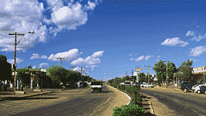
Meekatharra is situated on the Great Northern Highway in the Murchison-East
Gascoyne region of Western Australia. It is the centre of a mining and
sheep and cattle district. Travellers passing through the area will be
interested by the many old worked out gold mines and the relics of old
machinery that go with them. The airport is located 5km from the town
centre
The largest town in the Murchison district with a population of approximately
1400. Surrounded by large open cut gold fields, cattle and sheep stations
and beautiful waterholes with migratory bird life from around the world,
this offers a true taste of unique outback Australia. Meekatharra provides
the gateway to the remote Gunbarrel Highway and to the northwest of Western
Australia.
The population comprises approximately 40% Aboriginal people, a large
mining sector, pastoral community members and members of various businesses,
agencies and organizations that support the town.
Images and information placed above are from
www.airportsaustralia.com
http://www.landroverclub.net
We thank them for the data!
| General Info
|
| Country |
Australia
|
| ICAO ID |
YMEK
|
| Time |
UTC+8
|
| Latitude |
-26.611667
26° 36' 42.00" S
|
| Longitude |
118.547778
118° 32' 52.00" E
|
| Elevation |
1713 feet
522 meters
|
| Magnetic Variation |
001° E (01/04)
|
| Operating Agency |
CIVIL GOVERNMENT, (LANDING FEES AND DIPLOMATIC CLEARANCE MAY BE REQUIRED)
|
| Communications
|
| MTAF |
126.7
|
| MELBOURNE CNTR |
122.6
|
| Communications Remarks |
|
| FSS |
(on gnd)
|
| Runways
|
| ID |
Dimensions |
Surface |
PCN |
ILS
|
| 09/27 |
7156 x 98 feet
2181 x 30 meters |
ASPHALT |
018FAYT |
NO
|
| 15/33 |
3494 x 98 feet
1065 x 30 meters |
SAND, GRADED, ROLLED OR OILED. |
- |
NO
|
| Navaids
|
| Type |
ID |
Name |
Channel |
Freq |
Distance From Field |
Bearing From Navaid
|
| VOR-DME |
MEK |
MEEKATHARRA |
076X |
112.9 |
At Field |
-
|
| NDB |
MEK |
MEEKATHARRA |
- |
251 |
At Field |
-
|
| Supplies/Equipment
|
| Fuel |
Jet A1, without icing nhibitor.
100/130 MIL Spec, low lead, aviation gasoline (BLUE)
|
| Remarks
|
| FUEL |
Avbl 0001-0900Z Mon-Fri exc hol; HO or O/R Sat, Sun and hol; OT 20 min PN. Fone C08 9981 1179. (NC-100LL, A1)
|
| LGT |
Rot bcn avbl O/R.
|
| MISC |
Ldg fee.
|
| RSTD |
Rwy 09-27 180 turns to be made at turning nodes only.
|
Runway 09/27
7156 x 98 feet
2181 x 30 meters
| Runway 09
|
| Surface |
ASPHALT
|
| True Heading |
085.0
|
| Latitude |
-26.609128
26° 36' 32.86" S
|
| Longitude |
118.535097
118° 32' 06.35" E
|
| Elevation |
1691.0 feet
515 meters
|
| Slope |
-0.1°
|
| Landing Distance |
7156 feet
2181 meters
|
| Takeoff Distance |
7156 feet
2181 meters
|
| Lighting System |
LIRL
|
| Runway 27
|
| Surface |
ASPHALT
|
| True Heading |
265.0
|
| Latitude |
-26.607375
26° 36' 26.55" S
|
| Longitude |
118.556914
118° 33' 24.89" E
|
| Elevation |
1681.0 feet
512 meters
|
| Slope |
0.1°
|
| Landing Distance |
7156 feet
2181 meters
|
| Takeoff Distance |
7156 feet
2181 meters
|
| Lighting System |
LIRL
|
Runway 15/33
3494 x 98 feet
1065 x 30 meters
| Runway 15
|
| Surface |
SAND, GRADED, ROLLED OR OILED.
|
| True Heading |
139.0
|
| Latitude |
-26.608525
26° 36' 30.69" S
|
| Longitude |
118.548189
118° 32' 53.48" E
|
| Elevation |
1687.0 feet
514 meters
|
| Slope |
0.2°
|
| Landing Distance |
3494 feet
1065 meters
|
| Takeoff Distance |
3494 feet
1065 meters
|
| Runway 33
|
| Surface |
SAND, GRADED, ROLLED OR OILED.
|
| True Heading |
319.0
|
| Latitude |
-26.616631
26° 36' 59.87" S
|
| Longitude |
118.556028
118° 33' 21.70" E
|
| Elevation |
1693.0 feet
516 meters
|
| Slope |
-0.2°
|
| Landing Distance |
3494 feet
1065 meters
|
| Takeoff Distance |
3494 feet
1065 meters
|
Navaids
| MEEKATHARRA
|
| Type |
ID |
Channel |
Freq |
Country |
State
|
| NDB |
MEK |
- |
251 |
Australia |
-
|
| Latitude |
Longitude |
Airport
|
-26.615556
26° 36' 56.00" S |
118.540278
118° 32' 25.00" E |
YMEK
|
| MEEKATHARRA
|
| Type |
ID |
Channel |
Freq |
Country |
State
|
| VOR-DME |
MEK |
076X |
112.9 |
Australia |
-
|
| Latitude |
Longitude |
Airport
|
-26.606944
26° 36' 25.00" S |
118.532500
118° 31' 57.00" E |
YMEK
|
The content above was published at Airports-Worldwide.com in 2004-2006.
We don't guarantee the information is fresh and accurate. The data may be wrong or outdated.
For more up-to-date information please refer to other sources.
|
 |


