 |
 |
|
||||
|
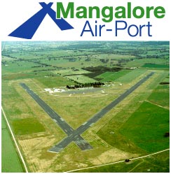
Images and information placed above are from Mangalore Airport We thank them for the data!
Runway 05/236650 x 148 feet
|
|||||||||||||||||||||||||||||||||||||||||||||||||||||||||||||||||||||||||||||||||||||||||||||||||||||||||||||||||||||||||||||||||||||||||||||||||||||||||||||||||||||||||||||||||||||||||||||||||||||||||||||||||||||||||||||||||||||||||||||||||||||||||||||||||||||||||||||||||||||||||||||||||||||||||||||||||||||||||
| Runway 05 | |
|---|---|
| Surface | ASPHALT |
| True Heading | 053.0 |
| Latitude | -36.893464 36° 53' 36.47" S |
| Longitude | 145.172978 145° 10' 22.72" E |
| Elevation | 457.0 feet 139 meters |
| Slope | 0.1° |
| Landing Distance | 6650 feet 2027 meters |
| Takeoff Distance | 6650 feet 2027 meters |
| Lighting System | LIRL |
| Runway 23 | |
|---|---|
| Surface | ASPHALT |
| True Heading | 233.0 |
| Latitude | -36.882744 36° 52' 57.88" S |
| Longitude | 145.191378 145° 11' 28.96" E |
| Elevation | 463.0 feet 141 meters |
| Slope | -0.1° |
| Landing Distance | 6650 feet 2027 meters |
| Takeoff Distance | 6650 feet 2027 meters |
| Lighting System | LIRL |
| Runway 18 | |
|---|---|
| Surface | ASPHALT |
| True Heading | 189.0 |
| Latitude | -36.882772 36° 52' 57.98" S |
| Longitude | 145.190000 145° 11' 24.00" E |
| Elevation | 462.0 feet 141 meters |
| Slope | 0.1° |
| Landing Distance | 4793 feet 1461 meters |
| Takeoff Distance | 4793 feet 1461 meters |
| Lighting System | LIRL |
| Runway 36 | |
|---|---|
| Surface | ASPHALT |
| True Heading | 009.0 |
| Latitude | -36.895764 36° 53' 44.75" S |
| Longitude | 145.187414 145° 11' 14.69" E |
| Elevation | 467.0 feet 142 meters |
| Slope | -0.1° |
| Landing Distance | 4793 feet 1461 meters |
| Takeoff Distance | 4793 feet 1461 meters |
| Lighting System | LIRL |
| MANGALORE | |||||
|---|---|---|---|---|---|
| Type | ID | Channel | Freq | Country | State |
| NDB | MNG | - | 254 | Australia | - |
| Latitude | Longitude | Airport |
| -36.898611 36° 53' 55.00" S |
145.180000 145° 10' 48.00" E |
YMNG |
| MANGALORE | |||||
|---|---|---|---|---|---|
| Type | ID | Channel | Freq | Country | State |
| VOR | MNG | - | 113.2 | Australia | - |
| Latitude | Longitude | Airport |
| -36.886111 36° 53' 10.00" S |
145.194167 145° 11' 39.00" E |
YMNG |
| MANGALORE | |||||
|---|---|---|---|---|---|
| Type | ID | Channel | Freq | Country | State |
| VOR-DME | MML | 089X | 114.2 | India | - |
| Latitude | Longitude | Airport |
| 12.961947 12° 57' 43.01" N |
74.921639 074° 55' 17.90" E |
VOML |
| MANGALORE | |||||
|---|---|---|---|---|---|
| Type | ID | Channel | Freq | Country | State |
| NDB | ML | - | 357 | India | - |
| Latitude | Longitude | Airport |
| 12.961861 12° 57' 42.70" N |
74.892750 074° 53' 33.90" E |
VOML |
The content above was published at Airports-Worldwide.com in 2004-2006.
We don't guarantee the information is fresh and accurate. The data may be wrong or outdated.
For more up-to-date information please refer to other sources.

 |
|
Copyright 2004-2026 © by Airports-Worldwide.com, Vyshenskoho st. 36, Lviv 79010, Ukraine Legal Disclaimer |
 Operator: Managlore Airport Pty Ltd
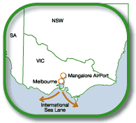 Mangalore is a rural village and district 12 km north of Seymour in central northern Victoria. It is the junction where the northern railway line branches to Shepparton and Wodonga.