 |
|
Kingscote-Kangaroo Island Airport |
|
|
 Operator: Kangaroo Island Council
Address:
PO Box 121
Kingscote SA 5223
Australia
Phone: +61 8 85532015
Fax: +61 8 85542885
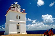
Kangaroo Island (including Kingscote, American River, Parndana and Penneshaw)
Enjoy one of the world's most beautiful and unique wilderness holiday
destinations. Meet the locals - wallabies, goannas, koalas, kangaroos,
echidnas, dolphins, sea lions, penguins, fur seals, eagles, whales and
ospreys, just to name a few. Share with them the pure air and clean water
that makes Kangaroo Island one of the last unspoiled wonders of the world.
The airport is located 12 km from Kingscote town centre.
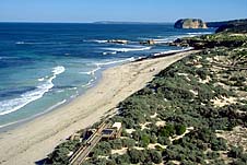 Australia's third-largest island. A superb and fascinating wilderness
mixed with a number of attractive small townships.
Australia's third-largest island. A superb and fascinating wilderness
mixed with a number of attractive small townships.
Located 110 km south-west of Adelaide and easily accessible by ferry,
Kangaroo Island is one of the nation's supreme scenic spots.
Kangaroo Island is Australia's third largest island (after Tasmania and
Melville Island) stretching 155 km from east to west, 55 km at its widest
point, and containing nearly 1600 km of sealed and unsealed roads.
The island was first settled by Aborigines but their history is scant
and complex. It seems they left the island about 3,000 years ago for reasons
which remain unknown.
The first European to see the island was Matthew Flinders who, during
his circumnavigation of Australia in the 'Investigator' in 1802, explored,
charted and named the island.
Flinders and his crew killed 31 kangaroos and as he wrote "half a hundredweight
of heads, forequarters and tails were stewed into soup...and as much steaks
given....to both officers and men as they could consume by day and by
night.... In gratitude for so seasonable a supply, I named this southern
land Kangaroo Island ..." Flinders also named the strait between the island
and the mainland declaring "It forms a private entrance, as it were, to
the two gulphs; and I named it Backstairs Passage".
Images and information placed above are from
www.walkabout.com.au
We thank them for the data!
| General Info
|
| Country |
Australia
|
| ICAO ID |
YKSC
|
| Time |
UTC+9:30(+10:30DT)
|
| Latitude |
-35.713889
35° 42' 50.00" S
|
| Longitude |
137.521389
137° 31' 17.00" E
|
| Elevation |
24 feet
7 meters
|
| Magnetic Variation |
008° E (01/04)
|
| Beacon |
Yes
|
| Operating Agency |
CIVIL GOVERNMENT, (LANDING FEES AND DIPLOMATIC CLEARANCE MAY BE REQUIRED)
|
| Communications
|
| MTAF |
126.0
|
| MELBOURNE CNTR |
123.05
|
| Communications Remarks |
|
| MISC |
Nstd to 4000'. Pro do not apply within YMR279 when active.
|
| FSS |
(on gnd)
|
| Runways
|
| ID |
Dimensions |
Surface |
PCN |
ILS
|
| 01/19 |
4600 x 98 feet
1402 x 30 meters |
ASPHALT |
012FCZT |
NO
|
| 06/24 |
3720 x 98 feet
1134 x 30 meters |
GRAVEL. |
- |
NO
|
| 15/33 |
3819 x 98 feet
1164 x 30 meters |
GRAVEL. |
- |
NO
|
| Navaids
|
| Type |
ID |
Name |
Channel |
Freq |
Distance From Field |
Bearing From Navaid
|
| NDB |
KSC |
KINGSCOTE |
- |
215 |
At Field |
-
|
| Supplies/Equipment
|
| Fuel |
Jet A1, without icing nhibitor.
100/130 MIL Spec, low lead, aviation gasoline (BLUE)
|
| Remarks
|
| CAUTION |
Bird and animal haz.
|
| FUEL |
(NC-100LL) Fone C08 8264 3711.
|
| LGT |
ACTIVATE-Rwy 01-19 -122.3. Dur daylt hrs only T-VASI and WDI act. Rwy lgt, bcn and apron flood lgt will opr only when poor lgt levels exist. Portable lgt emerg only.
|
| MISC |
300' of apch ends of Rwy 24 and 33 asphalt. Ldg fees.
|
Runway 01/19
4600 x 98 feet
1402 x 30 meters
| Runway 01
|
| Surface |
ASPHALT
|
| True Heading |
021.0
|
| Latitude |
-35.721178
35° 43' 16.24" S
|
| Longitude |
137.522917
137° 31' 22.50" E
|
| Elevation |
22.0 feet
7 meters
|
| Slope |
0.0°
|
| Landing Distance |
4600 feet
1402 meters
|
| Takeoff Distance |
4600 feet
1402 meters
|
| Lighting System |
PCL
LIRL
VA
PORTABLE |
| Runway 19
|
| Surface |
ASPHALT
|
| True Heading |
201.0
|
| Latitude |
-35.709400
35° 42' 33.84" S
|
| Longitude |
137.528564
137° 31' 42.83" E
|
| Elevation |
21.0 feet
6 meters
|
| Slope |
0.0°
|
| Landing Distance |
4600 feet
1402 meters
|
| Takeoff Distance |
4600 feet
1402 meters
|
| Lighting System |
PCL
LIRL
VA
PORTABLE |
Runway 06/24
3720 x 98 feet
1134 x 30 meters
| Runway 06
|
| Surface |
GRAVEL.
|
| True Heading |
066.0
|
| Latitude |
-35.714856
35° 42' 53.48" S
|
| Longitude |
137.516844
137° 31' 00.64" E
|
| Elevation |
24.0 feet
7 meters
|
| Slope |
-0.1°
|
| Landing Distance |
3720 feet
1134 meters
|
| Takeoff Distance |
3720 feet
1134 meters
|
| Lighting System |
PORTABLE
|
| Runway 24
|
| Surface |
GRAVEL.
|
| True Heading |
246.0
|
| Latitude |
-35.710758
35° 42' 38.73" S
|
| Longitude |
137.528331
137° 31' 41.99" E
|
| Elevation |
20.0 feet
6 meters
|
| Slope |
0.1°
|
| Landing Distance |
3720 feet
1134 meters
|
| Takeoff Distance |
3720 feet
1134 meters
|
| Lighting System |
PORTABLE
|
Runway 15/33
3819 x 98 feet
1164 x 30 meters
| Runway 15
|
| Surface |
GRAVEL.
|
| True Heading |
156.0
|
| Latitude |
-35.710642
35° 42' 38.31" S
|
| Longitude |
137.518600
137° 31' 06.96" E
|
| Elevation |
22.0 feet
7 meters
|
| Slope |
0.0°
|
| Landing Distance |
3819 feet
1164 meters
|
| Takeoff Distance |
4419 feet
1347 meters
|
| Overrun Length |
600 feet
183 meters
|
| Overrun Surface |
GRAVEL.
|
| Lighting System |
PORTABLE
|
| Runway 33
|
| Surface |
GRAVEL.
|
| True Heading |
336.0
|
| Latitude |
-35.720275
35° 43' 12.99" S
|
| Longitude |
137.523767
137° 31' 25.56" E
|
| Elevation |
21.0 feet
6 meters
|
| Slope |
0.0°
|
| Landing Distance |
3819 feet
1164 meters
|
| Takeoff Distance |
4719 feet
1438 meters
|
| Overrun Length |
900 feet
274 meters
|
| Overrun Surface |
GRAVEL.
|
| Lighting System |
PORTABLE
|
Navaids
| KINGSCOTE
|
| Type |
ID |
Channel |
Freq |
Country |
State
|
| NDB |
KSC |
- |
215 |
Australia |
-
|
| Latitude |
Longitude |
Airport
|
-35.709167
35° 42' 33.00" S |
137.514167
137° 30' 51.00" E |
YKSC
|
The content above was published at Airports-Worldwide.com in 2004-2006.
We don't guarantee the information is fresh and accurate. The data may be wrong or outdated.
For more up-to-date information please refer to other sources.
|
 |


