Derby is situated in the northern area of Australia's North West tourist
region. Derby faces north to the Timor Sea and is on the mud flats of
King Sound. Derby is the nearest town to the magnificent Buccaneer Archipelago.
Climate
Derby has a Tropical climate which is pleasant for most of the year.
With warm Winters and hot, humid Summers, the temperature is hardly ever
cold. The town is subject to cyclones between December and February, however
the warm, torrential rain is a great feature of the wet season. In Summer
(December to February), the average maximum temperature is 36°C with
an average minimum temperature of 25°C. In Winter (June to August),
the average maximum temperature is 32°C with an average minimum temperature
of 18°C.
Brief History
The coastline around Derby was first explored in 1688 and was followed
later by Phillip Parker King who, from 1818 to 1822 explored the region
and named King Sound, on which Derby is currently located. It wasn't until
1879 that any European settlement of the area occurred. Isolation and
harsh conditions had combined to ensure that only the most tenacious of
pastoralists and workers came to the area.
In 1883 a grid pattern was laid out for roads and Derby was born. A Jetty
was built in 1885 and the area began exporting wool products and the establishment
of cattle ranches followed. The town's name was bestowed in honour of
the British Secretary of state at the time.
Rwy 05-23 290' asphalt SW end, 610' asphalt NE end and 1060' asphalt in cntr. Arpt opr fone C089-191-1706 or C089-191-1479.
OIL
O-117-123-125-156.
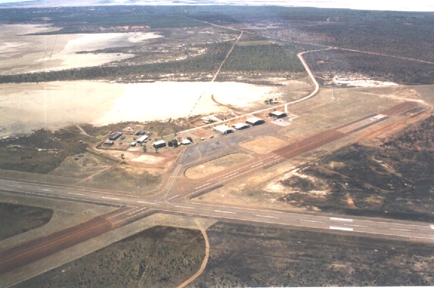
Runway 05/23
3799 x 59 feet
1158 x 18 meters
Runway 05
Surface
GRAVEL.
True Heading
056.0
Latitude
-17.374578 17° 22' 28.48" S
Longitude
123.658292 123° 39' 29.85" E
Elevation
23.0 feet 7 meters
Slope
-0.1°
Landing Distance
3799 feet 1158 meters
Takeoff Distance
3799 feet 1158 meters
Lighting System
PORTABLE
Runway 23
Surface
GRAVEL.
True Heading
236.0
Latitude
-17.368764 17° 22' 07.55" S
Longitude
123.667322 123° 40' 02.36" E
Elevation
19.0 feet 6 meters
Slope
0.1°
Landing Distance
3799 feet 1158 meters
Takeoff Distance
3799 feet 1158 meters
Lighting System
PORTABLE
Runway 11/29
5696 x 98 feet
1736 x 30 meters
Runway 11
Surface
ASPHALT
True Heading
111.0
Latitude
-17.368844 17° 22' 07.84" S
Longitude
123.653447 123° 39' 12.41" E
Elevation
18.0 feet 5 meters
Slope
0.1°
Landing Distance
5696 feet 1736 meters
Takeoff Distance
5696 feet 1736 meters
Lighting System
PCL
LIRL PORTABLE
Runway 29
Surface
ASPHALT
True Heading
291.0
Latitude
-17.374317 17° 22' 27.54" S
Longitude
123.668758 123° 40' 07.53" E
Elevation
24.0 feet 7 meters
Slope
-0.1°
Landing Distance
5696 feet 1736 meters
Takeoff Distance
5696 feet 1736 meters
Lighting System
PCL
LIRL PORTABLE
Navaids
DERBY
Type
ID
Channel
Freq
Country
State
NDB
DBY
-
332
Australia
-
Latitude
Longitude
Airport
-17.356944 17° 21' 25.00" S
123.666944 123° 40' 01.00" E
YDBY
The content above was published at Airports-Worldwide.com in 2004-2006.
We don't guarantee the information is fresh and accurate. The data may be wrong or outdated.
For more up-to-date information please refer to other sources.