 |
|
 Operator: Cook Shire Council
Address:
PO Box 3
Cooktown QLD 4871
Australia
Phone: +61 7 40695444
 Airport Code : CTN
Airport name : Cooktown Airport
Runway Length : 5340 ft.
Runway Elevation : 26 ft.
City : Cooktown QL
Country : Australia
Country Abbrev. : AU
World Area Code : 802
GMT Offset : -10.0
Longitude : 145� 11' 0" E
Latitude : 15� 27' 0" S
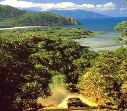
Cape York Peninsula is one of the world's last wilderness frontiers, and remains a vast land mass with few people and prolific wildlife. Gateway to this region is Cooktown, so named for Captain Cook's stay here in 1770 when repairing the "Endeavour "which was damaged on the Great Barrier Reef. The Airport is located 7.5 km from the town centre.
URL: Cooktown Airport
URL: Cooktown
Images and information placed above are from
Cooktown
Airport
Cooktown
We thank them for the data!
| General Info
|
| Country |
Australia
|
| ICAO ID |
YCKN
|
| Time |
UTC+10
|
| Latitude |
-15.444722
15° 26' 41.00" S
|
| Longitude |
145.184444
145° 11' 04.00" E
|
| Elevation |
26 feet
8 meters
|
| Magnetic Variation |
007° E (01/04)
|
| Operating Agency |
CIVIL GOVERNMENT, (LANDING FEES AND DIPLOMATIC CLEARANCE MAY BE REQUIRED)
|
| Communications
|
| BRISBANE CNTR |
134.65
|
| CTAF |
126.7
|
| Communications Remarks |
|
| FSS |
(on gnd)
|
| CTAF |
Nstd 15 NM Rad Cooktown NDB to 5000'.
|
| Runways
|
| ID |
Dimensions |
Surface |
PCN |
ILS
|
| 11/29 |
5338 x 98 feet
1627 x 30 meters |
ASPHALT |
009FBYU |
NO
|
| Navaids
|
| Type |
ID |
Name |
Channel |
Freq |
Distance From Field |
Bearing From Navaid
|
| NDB |
CKN |
COOKTOWN |
- |
260 |
4.3 NM |
293.9
|
| Remarks
|
| CAUTION |
Bird and animal haz. Mt Cook 762', 6 NM NE of RWY 11 cntrline.
|
| FUEL |
Fone C07 40695360. (NC-100LL,A1) Drums.
|
| LGT |
ACTIVATE-Rwy 11-29-123.9.
|
| MISC |
Ldg fees.
|
Runway 11/29
5338 x 98 feet
1627 x 30 meters
| Runway 11
|
| Surface |
ASPHALT
|
| True Heading |
111.0
|
| Latitude |
-15.440736
15° 26' 26.65" S
|
| Longitude |
145.175558
145° 10' 32.01" E
|
| Elevation |
24.0 feet
7 meters
|
| Slope |
-0.2°
|
| Landing Distance |
5338 feet
1627 meters
|
| Takeoff Distance |
5338 feet
1627 meters
|
| Lighting System |
PCL
LIRL |
| Runway 29
|
| Surface |
ASPHALT
|
| True Heading |
291.0
|
| Latitude |
-15.446111
15° 26' 46.00" S
|
| Longitude |
145.189672
145° 11' 22.82" E
|
| Elevation |
13.0 feet
4 meters
|
| Slope |
0.2°
|
| Landing Distance |
5338 feet
1627 meters
|
| Takeoff Distance |
5338 feet
1627 meters
|
| Lighting System |
PCL
LIRL |
Navaids
| COOKTOWN
|
| Type |
ID |
Channel |
Freq |
Country |
State
|
| NDB |
CKN |
- |
260 |
Australia |
-
|
| Latitude |
Longitude |
Airport
|
-15.481667
15° 28' 54.00" S |
145.248333
145° 14' 54.00" E |
YCKN
|
The content above was published at Airports-Worldwide.com in 2004-2006.
We don't guarantee the information is fresh and accurate. The data may be wrong or outdated.
For more up-to-date information please refer to other sources.
|
 |


