 |
|
|
|
|
|
 Operator: District Council of Coober Pedy
Address:
PO Box 425
Coober Pedy SA 5723
Australia
Phone: +61 8 86725298
Fax: +61 8 86725699
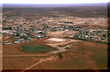
 Coober Pedy is an opal mining town located in the harsh Outback of South Australia, Australia, some 850 kilometres north of Adelaide and 690 kilometres south of Alice Springs. Coober Pedy is recognised as the largest producer of opal in the world with an estimated 70% of the world's precious opal being mined in the opal fields of the area.
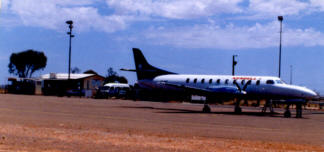
Airplan is working with Maunsell McIntyre on a commission from the District Council of Coober Pedy to undertake an Airport Feasibility Study to assist the Council in meeting a number of anticipated future needs.
Coober Pedy in outback South Australia is world renowned as the capital of opal mining, yielding over 70 percent of the world's opals.
The District Council has commissioned the Feasibility Study to assist it in developing a strategic plan to address the location, needs and form of the airport and to facilitate the concept of the desired development embodying township and regional requirements.
An interesting aspect is that the airport area is landlocked on all sides by "Precious Stones Fields" and opal mining activity.
Barry Munce is Airplan's technical specialist on the study team.
URL: Coober Pedy Airport
Images and information placed above are from
Coober
Pedy Airport
We thank them for the data!
| General Info
|
| Country |
Australia
|
| ICAO ID |
YCBP
|
| Time |
UTC+9:30(+10:30DT)
|
| Latitude |
-29.040000
29° 02' 24.00" S
|
| Longitude |
134.720833
134° 43' 15.00" E
|
| Elevation |
740 feet
226 meters
|
| Magnetic Variation |
006° E (01/04)
|
| Operating Agency |
CIVIL GOVERNMENT, (LANDING FEES AND DIPLOMATIC CLEARANCE MAY BE REQUIRED)
|
| Communications
|
| MELBOURNE CNTR |
120.7
|
| CTAF |
126.7
|
| Communications Remarks |
|
| FSS |
(7000')
|
| Runways
|
| ID |
Dimensions |
Surface |
PCN |
ILS
|
| 04/22 |
4685 x 98 feet
1428 x 30 meters |
PERMANENT, SURFACE TYPE UNKNOWN. |
- |
NO
|
| 14/32 |
2720 x 98 feet
829 x 30 meters |
GRASS OR EARTH NOT GRADED OR ROLLED. |
- |
NO
|
| Navaids
|
| Type |
ID |
Name |
Channel |
Freq |
Distance From Field |
Bearing From Navaid
|
| NDB |
CBP |
COOBER PEDY |
- |
341 |
At Field |
-
|
| Supplies/Equipment
|
| Fuel |
Jet A1, without icing nhibitor.
|
| Remarks
|
| FUEL |
(NC-100LL, A1)
|
| LGT |
ACTIVATE-Rwy 04-22-119.6. Portable lgt emerg only.
|
| MISC |
Ldg fee. Arpt opr fone C0408 693672, OT C08 8672 3114.
|
Runway 04/22
4685 x 98 feet
1428 x 30 meters
| Runway 04
|
| Surface |
PERMANENT, SURFACE TYPE UNKNOWN.
|
| True Heading |
049.0
|
| Latitude |
-29.044339
29° 02' 39.62" S
|
| Longitude |
134.714364
134° 42' 51.71" E
|
| Elevation |
729.0 feet
222 meters
|
| Slope |
0.2°
|
| Landing Distance |
4685 feet
1428 meters
|
| Takeoff Distance |
4685 feet
1428 meters
|
| Lighting System |
PCL
LIRL
PORTABLE |
| Runway 22
|
| Surface |
PERMANENT, SURFACE TYPE UNKNOWN.
|
| True Heading |
229.0
|
| Latitude |
-29.035889
29° 02' 09.20" S
|
| Longitude |
134.725439
134° 43' 31.58" E
|
| Elevation |
740.0 feet
226 meters
|
| Slope |
-0.2°
|
| Landing Distance |
4685 feet
1428 meters
|
| Takeoff Distance |
4685 feet
1428 meters
|
| Lighting System |
PCL
LIRL
PORTABLE |
Runway 14/32
2720 x 98 feet
829 x 30 meters
| Runway 14
|
| Surface |
GRASS OR EARTH NOT GRADED OR ROLLED.
|
| True Heading |
150.0
|
| Latitude |
-29.036453
29° 02' 11.23" S
|
| Longitude |
134.720989
134° 43' 15.56" E
|
| Elevation |
736.0 feet
224 meters
|
| Slope |
-0.1°
|
| Landing Distance |
2720 feet
829 meters
|
| Takeoff Distance |
2720 feet
829 meters
|
| Lighting System |
PORTABLE
|
| Runway 32
|
| Surface |
GRASS OR EARTH NOT GRADED OR ROLLED.
|
| True Heading |
330.0
|
| Latitude |
-29.042953
29° 02' 34.63" S
|
| Longitude |
134.725233
134° 43' 30.84" E
|
| Elevation |
734.0 feet
224 meters
|
| Slope |
0.1°
|
| Landing Distance |
2720 feet
829 meters
|
| Takeoff Distance |
2720 feet
829 meters
|
| Lighting System |
PORTABLE
|
Navaids
| COOBER PEDY
|
| Type |
ID |
Channel |
Freq |
Country |
State
|
| NDB |
CBP |
- |
341 |
Australia |
-
|
| Latitude |
Longitude |
Airport
|
-29.031944
29° 01' 55.00" S |
134.723889
134° 43' 26.00" E |
YCBP
|
The content above was published at Airports-Worldwide.com in 2004-2006.
We don't guarantee the information is fresh and accurate. The data may be wrong or outdated.
For more up-to-date information please refer to other sources.
|
 |


