 |
|
|
|
|
|
 Operator: Coffs Harbour City Council
Address:
PO Box 155
Coffs Harbour NSW 2450
Australia
Phone: +61 66484000
Fax: +61 66484381
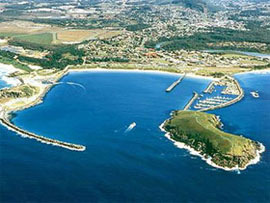
With it's natural beauty, lifestyle and modern facilities, the City of Coffs Harbour offers the most pleasant and comfortable living conditions in Australia.
Coffs Harbour has a large regional airport with commercial and general aviation facilities, charter airplane and helicopter services, aircraft maintenance services and a security carpark. There are two commercial airlines operating out of Coffs Harbour.
A temperate climate all year round, the average annual maximum temperature is 23�C, golden beaches, magnificent rainforests, nearby mountain ranges and clean air make it a great place to enjoy life. Informal Lifestyle, minimal commuting times, many leisure, sporting and social activities. It is a small place where people get to know one another quickly but still large enough to offer choices in where to live or what to do. Wherever you live by the beach or up in the mountains, the city centre is not far away, usually less than 20 minutes and traffic is not a problem.
There are many leisure activities to occupy you and your family. Some of these include: Licensed clubs, RSL, bowling, golf, yacht, fishing
URL: Coffs Harbour
Images and information placed above are from
Coffs
Harbour
We thank them for the data!
| General Info
|
| Country |
Australia
|
| ICAO ID |
YSCH
|
| Time |
UTC+10(+11DT)
|
| Latitude |
-30.320556
30° 19' 14.00" S
|
| Longitude |
153.116389
153° 06' 59.00" E
|
| Elevation |
18 feet
5 meters
|
| Type |
Civil
|
| Magnetic Variation |
012° E (01/04)
|
| Beacon |
Yes
|
| Operating Agency |
CIVIL GOVERNMENT, (LANDING FEES AND DIPLOMATIC CLEARANCE MAY BE REQUIRED)
|
| Communications
|
TWR
Opr 2200-0815Z++ Mon-Sat; 2345-0615Z++ Sun.
|
118.2
|
MTAF
Outside twr hrs.
|
118.2
|
| BRISBANE CNTR |
122.6
|
| ATIS |
117.0
130.3
|
| Communications Remarks |
|
| MISC |
Nstd wi CTLZ to 4500'.
|
| FSS |
(on gnd)
|
| Runways
|
| ID |
Dimensions |
Surface |
PCN |
ILS
|
| 03/21 |
6824 x 148 feet
2080 x 45 meters |
ASPHALT |
025FAYT |
NO
|
| 10/28 |
2785 x 60 feet
849 x 18 meters |
ASPHALT |
- |
NO
|
| Navaids
|
| Type |
ID |
Name |
Channel |
Freq |
Distance From Field |
Bearing From Navaid
|
| VOR-DME |
CH |
COFFS HARBOUR |
117X |
117 |
At Field |
-
|
| NDB |
CH |
COFFS HARBOUR |
- |
311 |
At Field |
-
|
| Supplies/Equipment
|
| Fuel |
Jet A1, without icing nhibitor.
100/130 MIL Spec, low lead, aviation gasoline (BLUE)
|
| Oil |
O-117, 1100, Reciprocating Engine Oil (MIL L 6082)
O-156, MIL L 23699 (Synthetic Base)Turboprop/Turboshaft Engine
|
| Remarks
|
| CAUTION |
Old Rwy 19 (Twy E3-E5) has been mistaken for Rwy 21 in marginal wx cond. Confirmrwy ident by rwy mrk or T-VASI prior to ldg. Down-drafts and severe turbulence may be experienced in strong wind cond when using Rwy 10 for ldg and Rwy 28 fortkof. Parasailing opr wi harbor SR-SS to 150'.
|
| FUEL |
(NC-100LL, A1) Avbl 2100-1000Z++, OT 1 hr PN, fone C02 66512444.
|
| LGT |
ACTIVATE-Rwy 03-21-125.1 outside twr hr.
|
| MISC |
Rwy 03-21 grooved. Ldg fees.
|
| OIL |
O-117-156
|
| TFC PAT |
Rwy 03 rgt hand circuits exc as directed by ATC.
|
Runway 03/21
6824 x 148 feet
2080 x 45 meters
| Runway 03
|
| Surface |
ASPHALT
|
| True Heading |
041.0
|
| Latitude |
-30.338375
30° 20' 18.15" S
|
| Longitude |
153.106547
153° 06' 23.57" E
|
| Elevation |
14.0 feet
4 meters
|
| Slope |
0.1°
|
| Landing Distance |
6824 feet
2080 meters
|
| Takeoff Distance |
6824 feet
2080 meters
|
| Lighting System |
PCL
MIRL
PAPI |
| Runway 21
|
| Surface |
ASPHALT
|
| True Heading |
221.0
|
| Latitude |
-30.324153
30° 19' 26.95" S
|
| Longitude |
153.120656
153° 07' 14.36" E
|
| Elevation |
18.0 feet
5 meters
|
| Slope |
-0.1°
|
| Landing Distance |
6824 feet
2080 meters
|
| Takeoff Distance |
6824 feet
2080 meters
|
| Lighting System |
PCL
MIRL
PAPI |
Runway 10/28
2785 x 60 feet
849 x 18 meters
| Runway 10
|
| Surface |
ASPHALT
|
| True Heading |
107.0
|
| Latitude |
-30.316450
30° 18' 59.22" S
|
| Longitude |
153.114094
153° 06' 50.74" E
|
| Elevation |
9.0 feet
3 meters
|
| Slope |
0.2°
|
| Landing Distance |
2379 feet
725 meters
|
| Takeoff Distance |
2785 feet
849 meters
|
| Displaced Threshold Length |
406 feet
124 meters
|
| Runway 28
|
| Surface |
ASPHALT
|
| True Heading |
287.0
|
| Latitude |
-30.318708
30° 19' 07.35" S
|
| Longitude |
153.122564
153° 07' 21.23" E
|
| Elevation |
15.0 feet
5 meters
|
| Slope |
-0.2°
|
| Landing Distance |
2785 feet
849 meters
|
| Takeoff Distance |
2785 feet
849 meters
|
Navaids
| COFFS HARBOUR
|
| Type |
ID |
Channel |
Freq |
Country |
State
|
| NDB |
CH |
- |
311 |
Australia |
-
|
| Latitude |
Longitude |
Airport
|
-30.312222
30° 18' 44.00" S |
153.117222
153° 07' 02.00" E |
YSCH
|
| COFFS HARBOUR
|
| Type |
ID |
Channel |
Freq |
Country |
State
|
| VOR-DME |
CH |
117X |
117 |
Australia |
-
|
| Latitude |
Longitude |
Airport
|
-30.319167
30° 19' 09.00" S |
153.116111
153° 06' 58.00" E |
YSCH
|
The content above was published at Airports-Worldwide.com in 2004-2006.
We don't guarantee the information is fresh and accurate. The data may be wrong or outdated.
For more up-to-date information please refer to other sources.
|
 |


