|
|
Coordinates: 18°20′14″N 064°58′24″W / 18.33722°N 64.97333°W / 18.33722; -64.97333
| Cyril E. King Airport |
 |
| FAA airport diagram |
| IATA: STT – ICAO: TIST – FAA LID: STT |
| Summary |
| Airport type |
Public |
| Owner |
Virgin Islands Port Authority |
| Location |
Saint Thomas, U.S. Virgin Islands |
| Elevation AMSL |
23 ft / 7 m |
| Runways |
| Direction |
Length |
Surface |
| ft |
m |
| 10/28 |
7,000 |
2,134 |
Asphalt |
| Statistics (2008) |
| Aircraft operations |
84,273 |
| Based aircraft |
84 |
| Source: Federal Aviation Administration |
Cyril E. King Airport (IATA: STT, ICAO: TIST, FAA LID: STT) is a public airport located two miles (3 km) west of the central business district of Charlotte Amalie on the island of St. Thomas in the United States Virgin Islands. It is currently the busiest airport in the United States Virgin Islands, and one of the busiest in the eastern Caribbean. The airport also serves nearby St. John and is often used by those traveling to the British Virgin Islands.
It was known as Harry S Truman Airport until 1984, when it was renamed to honor Cyril Emmanuel King, the second elected governor of the U.S. Virgin Islands. A new airport opened in November 1990 and retained the name.
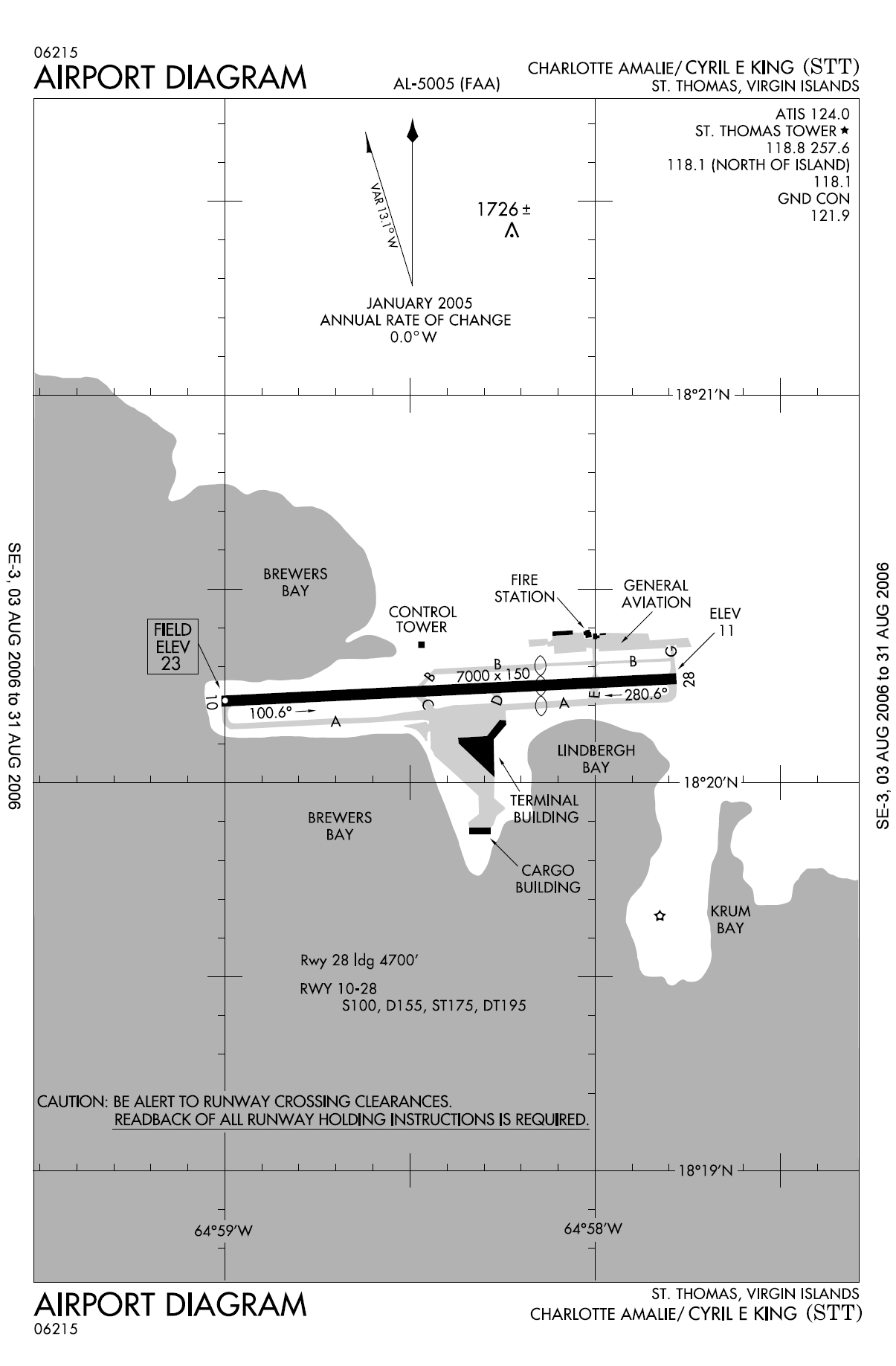
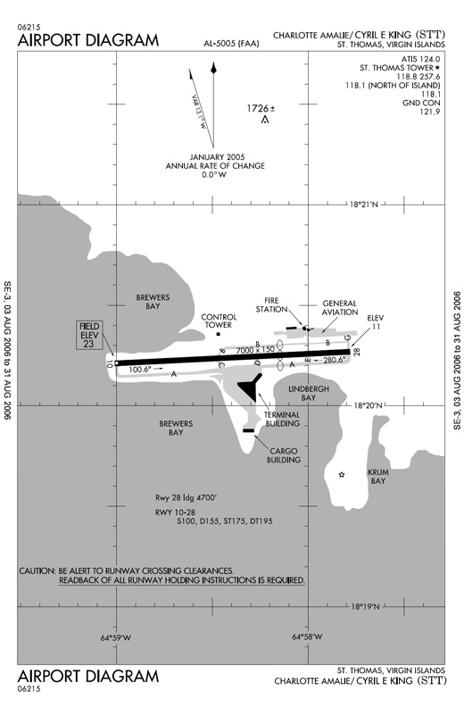
The airport operates one main runway, around 7,000 ft (2,100 m) long. The terminal operates 11 gates. Facilities and aircraft
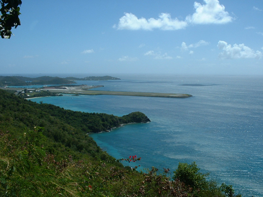 | |
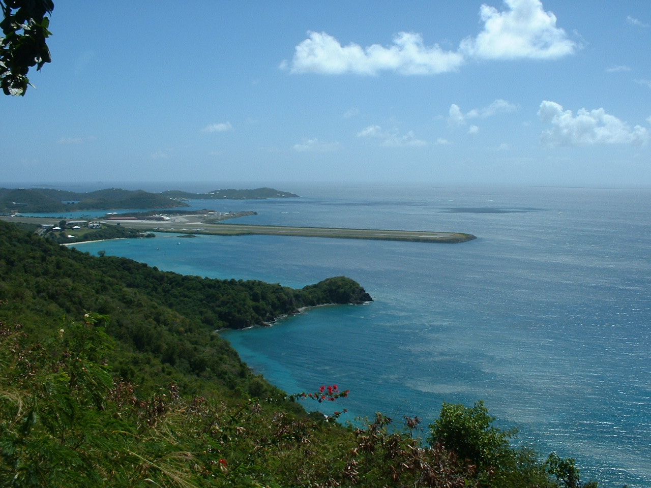
The Cyril E. King Airport from an observation overlook |
Cyril E. King Airport covers an area of 280 acres (113 ha) which contains one asphalt paved runway (10/28) measuring 7,000 x 150 ft (2,134 x 46 m). For the 12-month period ending January 31, 2008, the airport had 84,273 aircraft operations, an average of 230 per day: 50% air taxi, 15% scheduled commercial, 33% general aviation and 1% military. During the same period, there were 84 aircraft based at this airport: 57% multi-engine, 37% single engine, 5% helicopters and 1% ultralight.
Airlines and destinations
| Airlines |
Destinations |
| Air Sunshine |
Beef Island, San Juan, Vieques, Virgin Gorda |
| American Airlines |
Boston [seasonal], Miami, New York-JFK |
| American Eagle |
San Juan |
| Cape Air |
St. Croix, San Juan |
| Continental Airlines |
Newark |
| Delta Air Lines |
Atlanta, New York-JFK |
| LIAT |
Anguilla, Antigua, St. Kitts, St. Maarten |
| Seaborne Airlines |
St. Croix, San Juan-Isla Grande |
| Spirit Airlines |
Fort Lauderdale |
| Sun Country Airlines |
Minneapolis/St. Paul, San Juan [All Seasonal] |
| United Airlines |
Chicago-O'Hare, San Juan, Washington-Dulles [All Seasonal] |
| US Airways |
Charlotte, Philadelphia |
| Vieques Air Link |
Vieques |
Cargo
- Ameriflight (for UPS and DHL)
- Four Star Aviation
- FedEx
Accidents and incidents
On December 28, 1970, Trans Caribbean Airways Flight 505 made a hard landing and ran off the side of the runway. Two of the 48 passengers died in the subsequent fire.
On April 27, 1976, American Airlines Flight 625 ran off the end of the runway, killing 37 of the 88 on board the aircraft. Following the crash, American Airlines suspended jet service to the airport, using propliners until the runway was rebuilt to its present length.
On 25 March 1977, Douglas C-53 N692A of Island Traders was damaged beyond economic repair in a heavy landing.
On 17 September 1989, Douglas DC-3 N4425N, Douglas C-47s N100SD, N4471J and N4577Z; and Douglas C-49J N28346 of Aero Virgin Islands; along with Douglas C-47A N101AP of Four Star Air Cargo; were damaged beyond economic repair by Hurricane Hugo.
On 30 December 2003, Douglas DC-3C N781T of Tol-Air Services was substantially damaged when the starboard undercarriage collapsed on landing after a flight that originated at San Juan, Puerto Rico.
On 19 July 2006, Douglas DC-3C N782T of Tol-Air Services ditched into the sea off Charlotte Amalie after an engine failure shortly after take-off from Cyril E. King Airport. All four people on board escaped as the aircraft floated for about ten minutes before sinking. The aircraft now lies in 100 feet (30 m) of water and is a dive site.
World War II
During World War II, the United States Army Air Forces Sixth Air Force 23rd Fighter Squadron (36th Fighter Group) deployed P-40 Warhawk fighters to the airport from March 1942-May 1943.
The above content comes from Wikipedia and is published under free licenses – click here to read more.
| General Info
|
| Country |
Virgin Islands
|
| ICAO ID |
TIST
|
| Time |
UTC-4
|
| Latitude |
18.337306
18° 20' 14.30" N
|
| Longitude |
-64.973361
064° 58' 24.10" W
|
| Elevation |
23 feet
7 meters
|
| Type |
Civil
|
| Magnetic Variation |
013° W (01/06)
|
| Beacon |
Yes
|
| Operating Agency |
CIVIL GOVERNMENT, (LANDING FEES AND DIPLOMATIC CLEARANCE MAY BE REQUIRED)
|
| Near City |
St Thomas
|
| Island Group |
St. Thomas I
|
| Operating Hours |
SEE REMARKS FOR OPERATING HOURS OR COMMUNICATIONS FOR POSSIBLE HOURS
|
| International Clearance Status |
Landing Rights Airport
|
| Communications
|
| UNICOM |
122.95
|
ST THOMAS TWR
Opr 1100-0230Z
|
118.1
118.8
257.6
|
SAN JUAN RDO
(RCO at STT)
|
108.6
123.6
|
GND
Opr 1000-0300Z.
|
121.9
|
ST THOMAS DEP
Opr 1100-0230Z.
|
118.8
257.6
|
| CTAF |
118.8
|
| ATIS |
124.0
|
ST THOMAS APP
Opr 1100-0230Z.
|
118.8
257.6
|
SAN JUAN CNTR
Opr 0230-1100Z.
|
128.65
279.6
|
| Communications Remarks |
|
| A/D |
(APP DEP svc).
|
| Runways
|
| ID |
Dimensions |
Surface |
PCN |
ILS
|
| 10/28 |
7000 x 150 feet
2134 x 46 meters |
ASPHALT |
- |
YES
|
| Navaids
|
| Type |
ID |
Name |
Channel |
Freq |
Distance From Field |
Bearing From Navaid
|
| VOR-DME |
STT |
ST THOMAS |
023X |
108.6 |
3.1 NM |
123.7
|
| Supplies/Equipment
|
| Fuel |
Jet A, without icing inhibitor.
100/130 MIL Spec, low lead, aviation gasoline (BLUE)
|
| Remarks
|
| CAUTION |
Pilots may enctr false illusory indications dur ngt visual apch to Rwy 10 when using visual cues for vertical guidance. Rcmd use of the ILS GS and frequent cross ref with the acft altm to maint the proper apch profile. Rwy 10-28 cntrln andedge markings svrly faded in mult locations. Loose grav on Twy gates 5 and 7.
|
| FUEL |
Avbl 1100-2300Z. A (Alliance Aviation Fuels, Inc., C340-777-4646, $75 OT fee 3 hr PN, Bus Ph C340-771-6565) (NC-100LL).
|
| LGT |
When Twr clsd ACTIVATE - MIRL Rwy 10-28 - CTAF.
|
| MISC |
Ctc GND prior to pushback.
|
| NS ABTMT |
Noise Sensitive Area - Avoid ovft of Water Island 2 NM SE of arpt.
|
| OPR HOURS |
Opr 1100-0300Z.
|
| RSTD |
Rwy 10 dep maint rwy hdg until dep end before turning on crs or asgn hdg unless otherwise auth by ATC.
|
The content above was published at Airports-Worldwide.com in 2010.
We don't guarantee the information is fresh and accurate. The data may be wrong or outdated.
For more up-to-date information please refer to other sources.
|
|