|
|
Cam Ranh International Airport
Sân bay Quốc tế Cam Ranh |
 |
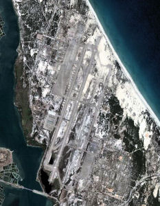
| 2008 aerial image of Cam Ranh airport |
| IATA: CXR – ICAO: VVCR |
| Summary |
| Airport type |
Public |
| Operator |
Government |
| Serves |
Nha Trang, Vietnam |
| Location |
Cam Ranh, Vietnam |
| Elevation AMSL |
40 ft / 12 m |
| Coordinates |
11°59′53″N 109°13′10″E / 11.99806°N 109.21944°E / 11.99806; 109.21944 |
| Runways |
| Direction |
Length |
Surface |
| ft |
m |
| 02/20 |
10,000 |
3,048 |
Concrete |
| Source: DAFIF |
Cam Ranh International Airport (IATA: CXR, ICAO: VVCR) (Vietnamese: Sân bay Quốc tế Cam Ranh) is located on Cam Ranh Bay in Cam Ranh, a town in the province of Khanh Hoa in Vietnam. It serves the city of Nha Trang, which is 30 km (16 NM) from the airport. History
Cam Ranh Airport was built by the United States Army during the Vietnam War, and operated by the United States Air Force for military purposes as Cam Ranh Air Base.
In 1972, the base was turned over to the South Vietnamese government. On April 3, 1975, North Vietnamese forces captured Cam Ranh Bay and all of its remaining facilities. From 1979 to 2002, the facility was used by the Soviet and then Russian Air Force because of a 25-year rent-free leasing treaty.
On May 19, 2004, after major reconstruction, the airport received its first commercial flight from Hanoi. It now handles all of Nha Trang's commercial flights, which previously headed to Nha Trang Airport. In 2007, Cam Ranh was upgraded to an international airport. In December, 2009 Cam Ranh International Airport was opened. The total invested capital is up to about 300 billion VND.
Facilities
The airport resides at an elevation of 40 feet (12 m) above mean sea level. It has one runway designated 02/20 with a concrete surface measuring 10,000 by 150 feet (3,048 × 46 m).
Airlines and destinations
| Airlines |
Destinations |
| Air Mekong |
Ha Noi [begins 10 October], Ho Chi Minh City [begins 10 October] |
| Jetstar Pacific Airlines |
Hanoi [seasonal] |
| S7 Airlines |
Novosibirsk [seasonal] |
| Vietnam Airlines |
Da Nang, Hanoi, Ho Chi Minh City |
New routes & airlines
- Aeroflot has been interested in Cam Ranh.
- Charter flights by Silk Air from Singapore.
- Vietnam Airlines has said to open flights to various parts of Asia, Korea has been mentioned.
The above content comes from Wikipedia and is published under free licenses – click here to read more.
| General Info
|
| Country |
Vietnam
|
| ICAO ID |
VVCR
|
| Time |
UTC+7
|
| Latitude |
11.998153
11° 59' 53.35" N
|
| Longitude |
109.219372
109° 13' 09.74" E
|
| Elevation |
40 feet
12 meters
|
| Type |
Civil
|
| Magnetic Variation |
000° W (01/06)
|
| Operating Agency |
CIVIL GOVERNMENT, (LANDING FEES AND DIPLOMATIC CLEARANCE MAY BE REQUIRED)
|
| Runways
|
| ID |
Dimensions |
Surface |
PCN |
ILS
|
| 02/20 |
10000 x 150 feet
3048 x 46 meters |
CONCRETE. |
042RBXT |
NO
|
| Navaids
|
| Type |
ID |
Name |
Channel |
Freq |
Distance From Field |
Bearing From Navaid
|
| VOR-DME |
CRA |
CAM RANH |
112X |
116.5 |
At Field |
-
|
| NDB |
CR |
CAM RANH |
- |
414 |
At Field |
-
|
The content above was published at Airports-Worldwide.com in 2010.
We don't guarantee the information is fresh and accurate. The data may be wrong or outdated.
For more up-to-date information please refer to other sources.
|
|