 |
|
Gtr Green River Intergalactic Spaceport Airport |
Greater Green River Intergalactic Spaceport
Green River Spaceport |
| IATA: none – ICAO: none – FAA LID: 48U |
| Summary |
| Airport type |
Public |
| Operator |
City of Green Rier |
| Location |
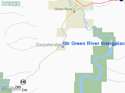
Green River, Wyoming |
| Elevation AMSL |
7,182 ft / 2,189 m |
| Coordinates |
41°27′28.872″N 109°29′25.489″W / 41.45802°N 109.49041361°W / 41.45802; -109.49041361Coordinates: 41°27′28.872″N 109°29′25.489″W / 41.45802°N 109.49041361°W / 41.45802; -109.49041361 |
| Runways |
| Direction |
Length |
Surface |
| ft |
m |
| 04/22 |
5,800 |
1,768 |
Dirt |
| Statistics (2007) |
| Aircraft operations |
34 |
| Source: Federal Aviation Administration |
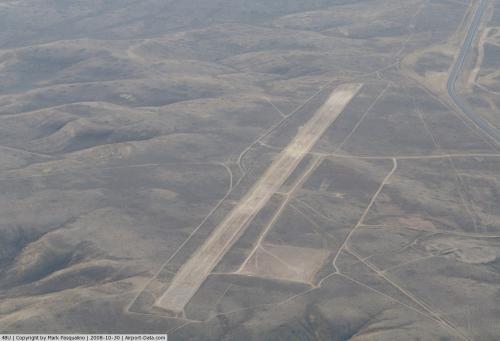
The Greater Green River Intergalactic Spaceport is a small public use airstrip located four nautical miles (7.4 km) south of the central business district of Green River, Wyoming on a mountain known locally as South Hill. The airport was opened in 1963. Facilities and aircraft
Greater Green River Intergalactic Spaceport covers an area of 400 acres (162 ha) at an elevation of 7,182 feet (2,189 m) above mean sea level. It has one runway designated 04/22 with a dirt/gravel surface measuring 5,800 by 130 feet (1,768 x 40 m) with deep ruts due to vehicular traffic. The runway is unattended, with no buildings or facilities, except a windsock. The runway does not have a clear line of sight from the runway ends. Communications are through CTAF and most of the services are from nearby Rock Springs - Sweetwater County Airport.
For the 12-month period ending July 31, 2007, the airport had 34 aircraft operations, an average of less than 1 per week: 100% general aviation. At that time, there were no aircraft based at this airport.
Spaceport
On July 5, 2004, Resolution R94-23 of the Green River city council designated this landing field as the "Greater Green River Intergalactic Spaceport", for inhabitants of Jupiter who might wish to take sanctuary in Green River in the event their planet is threatened by collisions from comets or meteors. Thus far, no spacecraft of any kind have actually used the spaceport, and actual use has been limited to terrestrial aircraft.
The above content comes from Wikipedia and is published under free licenses – click here to read more.
 |
(Click on the photo to enlarge) |
Location & QuickFacts
| FAA Information Effective: | 2008-09-25 |
| Airport Identifier: | 48U |
| Airport Status: | Operational |
| Longitude/Latitude: | 109-29-25.4890W/41-27-28.8720N
-109.490414/41.458020 (Estimated) |
| Elevation: | 7182 ft / 2189.07 m (Surveyed) |
| Land: | 400 acres |
| From nearest city: | 4 nautical miles S of Green River, WY |
| Location: | Sweetwater County, WY |
| Magnetic Variation: | 14E (1985) |
Owner & Manager
| Ownership: | Publicly owned |
| Owner: | City Of Green River |
| Address: | 50 E. 2 Nd N
Green River, WY 82935 |
| Phone number: | 307-872-0532 |
| Manager: | Public Works Director
LOCAL CONTACT MIKE NELSON. |
| Address: | 50 E 2nd N
Green River, WY 82935 |
| Phone number: | 307-872-0532 |
Airport Operations and Facilities
| Airport Use: | Open to public |
| Wind indicator: | Yes |
| Segmented Circle: | No |
| Control Tower: | No |
| Landing fee charge: | No |
| Sectional chart: | Salt Lake City |
| Region: | ANM - Northwest Mountain |
| Boundary ARTCC: | ZLC - Salt Lake City |
| Tie-in FSS: | CPR - Casper |
| FSS on Airport: | No |
| FSS Toll Free: | 1-800-WX-BRIEF |
| NOTAMs Facility: | CPR (NOTAM-d service avaliable) |
| Federal Agreements: | S |
Airport Communications
Airport Services
| Airframe Repair: | NONE |
| Power Plant Repair: | NONE |
| Bottled Oxygen: | NONE |
| Bulk Oxygen: | NONE |
Runway Information
Runway 04/22
| Dimension: | 5800 x 130 ft / 1767.8 x 39.6 m
WIDTH MAY VARY BASED ON GRADING. |
| Surface: | DIRT, Fair Condition |
| |
Runway 04 |
Runway 22 |
| Traffic Pattern: | Left | Left |
|
Radio Navigation Aids
| ID |
Type |
Name |
Ch |
Freq |
Var |
Dist |
| AOP | NDB | Antelope | | 290.00 | 13E | 23.7 nm |
| FBR | VOR/DME | Fort Bridger | 023X | 108.60 | 14E | 42.4 nm |
| OCS | VORTAC | Rock Springs | 107X | 116.00 | 13E | 22.8 nm |
Remarks
- RY SOFT WHEN WET. DEEP RUTS & TALL GRASS FULL LENGTH OF RY.
- ARPT ON TOP OF MOUNTAIN; LAND DESCENDS VERY STEEPLY FROM RWY ENDS.
- NO LINE OF SIGHT BTN RWY ENDS.
- NO SNOW REMOVAL AVAILABLE.
- UNCONTROLLED VEHICLE ACCESS.
- +3 FT BERM NEAR RY EDGES ENTIRE LENGTH OF RY.
Images and information placed above are from
http://www.airport-data.com/airport/48U/
We thank them for the data!
| General Info
|
| Country |
United States
|
| State |
WYOMING
|
| FAA ID |
48U
|
| Latitude |
41-27-28.872N
|
| Longitude |
109-29-25.489W
|
| Elevation |
7182 feet
|
| Near City |
GREEN RIVER
|
We don't guarantee the information is fresh and accurate. The data may
be wrong or outdated.
For more up-to-date information please refer to other sources.
|
|


