 |
|
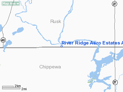
River Ridge Aero Estates Airport |
Location & QuickFacts
| FAA Information Effective: | 2008-09-25 |
| Airport Identifier: | 4WN4 |
| Airport Status: | Operational |
| Longitude/Latitude: | 091-13-58.5360W/45-17-38.6738N
-91.232927/45.294076 (Estimated) |
| Elevation: | 1050 ft / 320.04 m (Estimated) |
| Land: | 0 acres |
| From nearest city: | 8 nautical miles NW of Holcombe, WI |
| Location: | Rusk County, WI |
| Magnetic Variation: | 00E (2000) |
Owner & Manager
| Ownership: | Privately owned |
| Owner: | Michael And Fred Kleinheinz |
| Address: | W10765 County Hwy D
Holcombe, WI 54745 |
| Phone number: | 715-595-6665 |
| Manager: | Michael And Fred Kleinheinz |
| Address: | W10765 County Hwy D
Holcombe, WI 54745 |
| Phone number: | 715-595-6665 |
Airport Operations and Facilities
| Airport Use: | Private |
| Wind indicator: | Yes |
| Segmented Circle: | No |
| Control Tower: | No |
| Sectional chart: | Green Bay |
| Region: | AGL - Great Lakes |
| Boundary ARTCC: | ZMP - Minneapolis |
| Tie-in FSS: | GRB - Green Bay |
| FSS Toll Free: | 1-800-WX-BRIEF |
Runway Information
Runway 08/26
| Dimension: | 3100 x 100 ft / 944.9 x 30.5 m |
| Surface: | TURF, |
| |
Runway 08 |
Runway 26 |
| Traffic Pattern: | Left | Right |
| Displaced threshold: | 0.00 ft | 1000.00 ft
RY 26 DSPLCD THLD MARKED WITH TIRES. |
| Obstruction: | | 50 ft trees |
|
Runway 09W/27W
| Dimension: | 6000 x 600 ft / 1828.8 x 182.9 m |
| Surface: | WATER, |
| |
Runway 09W |
Runway 27W |
| Traffic Pattern: | Left | Left |
|
Runway 18/36
| Dimension: | 2000 x 100 ft / 609.6 x 30.5 m |
| Surface: | TURF, |
| |
Runway 18 |
Runway 36 |
| Traffic Pattern: | Left | Left |
| Obstruction: | 50 ft trees | 50 ft trees |
|
Radio Navigation Aids
| ID |
Type |
Name |
Ch |
Freq |
Var |
Dist |
| RCX | NDB | Rusk County | | 356.00 | 00W | 15.9 nm |
| UBE | NDB | Cumberland | | 375.00 | 01E | 33.9 nm |
| SSQ | NDB | Shell Lake | | 212.00 | 01E | 38.9 nm |
| MDZ | NDB | Medford | | 335.00 | 00E | 40.8 nm |
| PBH | NDB | Phillips | | 263.00 | 00E | 42.4 nm |
| AHH | NDB | Ameron | | 278.00 | 01E | 48.1 nm |
| SLY | NDB | Seeley | | 344.00 | 01E | 49.6 nm |
| RPD | VOR/DME | Rice Lake | 037X | 110.00 | 01E | 24.1 nm |
| HYR | VOR/DME | Hayward | 081X | 113.40 | 03E | 44.5 nm |
| EAU | VORTAC | Eau Claire | 076X | 112.90 | 04E | 26.0 nm |
Remarks
- OBSTRUCTIONS IN APPR SLOPE SURFACE BE LOWERED OR REMOVED TO PROVIDE 20:1 CLEARANCE; 125 FT EITHER SIDE OF RY CENTERLINE & 200 FT OFF RUNWAY ENDS CLEAR OF OBSTRUCTIONS.
Images and information placed above are from
http://www.airport-data.com/airport/4WN4/
We thank them for the data!
| General Info
|
| Country |
United States
|
| State |
WISCONSIN
|
| FAA ID |
4WN4
|
| Latitude |
45-17-38.674N
|
| Longitude |
091-13-58.536W
|
| Elevation |
1050 feet
|
| Near City |
WASHINGTON
|
We don't guarantee the information is fresh and accurate. The data may
be wrong or outdated.
For more up-to-date information please refer to other sources.
|
|


