 |
|
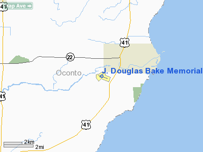
J. Douglas Bake Memorial. Airport |
Location & QuickFacts
| FAA Information Effective: | 2008-09-25 |
| Airport Identifier: | OCQ |
| Airport Status: | Operational |
| Longitude/Latitude: | 087-54-34.6190W/44-52-27.1090N
-87.909616/44.874197 (Estimated) |
| Elevation: | 604 ft / 184.10 m (Surveyed) |
| Land: | 210 acres |
| From nearest city: | 2 nautical miles SW of Oconto, WI |
| Location: | Oconto County, WI |
| Magnetic Variation: | 03W (1995) |
Owner & Manager
| Ownership: | Publicly owned |
| Owner: | Oconto City And County |
| Address: | 1210 Main Street
Oconto, WI 54153 |
| Phone number: | 920-834-7711 |
| Manager: | Eileen Duffeck |
| Address: | 2983 Airport Rd
Oconto, WI 54153 |
| Phone number: | 920-834-7727 |
Airport Operations and Facilities
| Airport Use: | Open to public |
| Wind indicator: | Yes |
| Segmented Circle: | Yes |
| Control Tower: | No |
| Lighting Schedule: | DUSK-DAWN
ACTVT MIRL RY 11/29 - 122.8. |
| Beacon Color: | Clear-Green (lighted land airport) |
| Landing fee charge: | No |
| Sectional chart: | Green Bay |
| Region: | AGL - Great Lakes |
| Boundary ARTCC: | ZMP - Minneapolis |
| Tie-in FSS: | GRB - Green Bay |
| FSS on Airport: | No |
| FSS Toll Free: | 1-800-WX-BRIEF |
| NOTAMs Facility: | GRB (NOTAM-d service avaliable) |
| Federal Agreements: | NGY |
Airport Communications
| CTAF: | 122.800 |
| Unicom: | 122.800 |
Airport Services
Runway Information
Runway 04/22
| Dimension: | 1845 x 150 ft / 562.4 x 45.7 m |
| Surface: | TURF, Fair Condition |
| |
Runway 04 |
Runway 22 |
| Longitude: | 087-54-46.3710W | 087-54-29.9160W |
| Latitude: | 44-52-23.9640N | 44-52-37.9280N |
| Alignment: | 40 | 127 |
| Traffic Pattern: | Left | Left |
| Markings: | None,
RY 04 /22 THLDS MKD WITH WHITE CONES. | None, |
| Runway End Identifier: | No | No |
| Centerline Lights: | No | No |
| Touchdown Lights: | No | No |
| Obstruction: | 50 ft trees, 1000.0 ft from runway, 200 ft right of centerline, 20:1 slope to clear | 45 ft trees, 900.0 ft from runway, 150 ft left of centerline, 20:1 slope to clear |
|
Runway 11/29
| Dimension: | 3199 x 75 ft / 975.1 x 22.9 m |
| Surface: | ASPH, Good Condition |
| Weight Limit: | Single wheel: 40000 lbs.
Dual wheel: 55000 lbs.
Dual tandem wheel: 90000 lbs. |
| Edge Lights: | Medium |
| |
Runway 11 |
Runway 29 |
| Longitude: | 087-54-53.5260W | 087-54-11.6450W |
| Latitude: | 44-52-30.1650N | 44-52-19.6270N |
| Elevation: | 604.00 ft | 601.00 ft |
| Alignment: | 109 | 127 |
| Traffic Pattern: | Left | Left |
| Markings: | Non-precision instrument, Good Condition | Non-precision instrument, Good Condition |
| Runway End Identifier: | Yes
RY 11 REIL OTS INDEFLY. | No |
| Centerline Lights: | No | No |
| Touchdown Lights: | No | No |
| Obstruction: | 50 ft tree, 1000.0 ft from runway, 250 ft left of centerline, 16:1 slope to clear | 35 ft trees, 900.0 ft from runway, 200 ft left of centerline, 20:1 slope to clear |
|
Radio Navigation Aids
| ID |
Type |
Name |
Ch |
Freq |
Var |
Dist |
| OCQ | NDB | Oconto | | 388.00 | 03W | 0.2 nm |
| SUE | NDB | Sturgeon Bay | | 414.00 | 03W | 20.9 nm |
| SG | NDB | Depre | | 332.00 | 02W | 30.1 nm |
| CLI | NDB | Clintonville | | 209.00 | 02W | 38.4 nm |
| AQ | NDB | Kooky | | 407.00 | 02W | 44.8 nm |
| MNM | VOR/DME | Menominee | 033X | 109.60 | 00E | 21.5 nm |
| MTW | VOR/DME | Manitowoc | 047X | 111.00 | 02W | 45.9 nm |
| GRB | VORTAC | Green Bay | 102X | 115.50 | 01E | 22.7 nm |
Remarks
- DEER ON RWYS NGTS, PILOTS REQD TO MAKE LOW PASS BEFORE LNDG.
- CONFIRM WINTER RY CONDITIONS & SNOW REMOVAL WITH AMGR 920-834-7727.
Images and information placed above are from
http://www.airport-data.com/airport/OCQ/
We thank them for the data!
| General Info
|
| Country |
United States
|
| State |
WISCONSIN
|
| FAA ID |
OCQ
|
| Latitude |
44-52-24.897N
|
| Longitude |
087-54-32.589W
|
| Elevation |
604 feet
|
| Near City |
OCONTO
|
We don't guarantee the information is fresh and accurate. The data may
be wrong or outdated.
For more up-to-date information please refer to other sources.
|
|


