 |
|
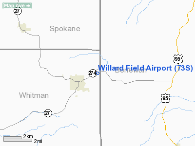
Location & QuickFacts
| FAA Information Effective: | 2008-09-25 |
| Airport Identifier: | 73S |
| Airport Status: | Operational |
| Longitude/Latitude: | 117-02-37.4990W/47-14-07.9220N
-117.043750/47.235534 (Estimated) |
| Elevation: | 2520 ft / 768.10 m (Estimated) |
| Land: | 25 acres |
| From nearest city: | 2 nautical miles NE of Tekoa, WA |
| Location: | Whitman County, WA |
| Magnetic Variation: | 19E (1985) |
Owner & Manager
| Ownership: | Publicly owned |
| Owner: | City Of Tekoa |
| Address: | Po Box 927
Tekoa, WA 99033 |
| Phone number: | 509-284-3861 |
| Manager: | Larry Hagan |
| Address: | Po Box 927
Tekoa, WA 99033 |
| Phone number: | 509-284-4143 |
Airport Operations and Facilities
| Airport Use: | Open to public |
| Wind indicator: | Yes |
| Segmented Circle: | No |
| Control Tower: | No |
| Lighting Schedule: | DUSK-DAWN
ACTVT MIRL RY 04/22 - 122.8. |
| Beacon Color: | Clear-Green (lighted land airport) |
| Landing fee charge: | No |
| Sectional chart: | Seattle |
| Region: | ANM - Northwest Mountain |
| Boundary ARTCC: | ZSE - Seattle |
| Tie-in FSS: | SEA - Seattle |
| FSS on Airport: | No |
| FSS Toll Free: | 1-800-WX-BRIEF |
| NOTAMs Facility: | SEA (NOTAM-d service avaliable) |
Airport Communications
Airport Services
| Fuel available: | 100LL
SELF SERVICE FUEL WITH CREDIT CARD. |
| Airframe Repair: | MAJOR |
| Power Plant Repair: | MAJOR |
| Bottled Oxygen: | NONE |
| Bulk Oxygen: | NONE |
Runway Information
Runway 04/22
| Dimension: | 2260 x 40 ft / 688.8 x 12.2 m |
| Surface: | ASPH, Good Condition |
| Edge Lights: | Medium |
| |
Runway 04 |
Runway 22 |
| Longitude: | 117-02-51.5370W | 117-02-23.4600W |
| Latitude: | 47-14-02.1830N | 47-14-13.6600N |
| Elevation: | 2520.00 ft | 2520.00 ft |
| Alignment: | 59 | 127 |
| Traffic Pattern: | Left | Left |
| Markings: | Nonstandard, Good Condition
RY 04/22 YELLOW CNTRLN ONLY. | Basic, Fair Condition |
| Obstruction: | 45 ft tree, 1068.0 ft from runway, 203 ft left of centerline, 19:1 slope to clear
RWY 04 TREE 150' FM RWY END; -3' DITCHES EITHER SIDE OF CO ROAD. | 92 ft pline, 3260.0 ft from runway, 300 ft right of centerline, 33:1 slope to clear
2' CO RD 40' FM END RWY, 4' DIRT BANK 80' FM THR. |
|
Radio Navigation Aids
| ID |
Type |
Name |
Ch |
Freq |
Var |
Dist |
| SFF | NDB | Felts | | 365.00 | 19E | 29.2 nm |
| DPY | NDB | Deer Park | | 216.00 | 19E | 46.7 nm |
| SKA | TACAN | Fairchild | 051X | | 19E | 33.8 nm |
| COE | VOR/DME | Coeur D'alene | 025X | 108.80 | 19E | 33.6 nm |
| PUW | VOR/DME | Pullman | 027X | 109.00 | 20E | 34.5 nm |
| GEG | VORTAC | Spokane | 102X | 115.50 | 21E | 30.9 nm |
| SFF | VOT | Spokane/felts Field | | 114.00 | | 29.0 nm |
| GEG | VOT | Spokane Intl | | 109.60 | | 30.8 nm |
Remarks
- ESTABD PRIOR TO 15 MAY 1959.
Images and information placed above are from
http://www.airport-data.com/airport/73S/
We thank them for the data!
| General Info
|
| Country |
United States
|
| State |
WASHINGTON
|
| FAA ID |
73S
|
| Latitude |
47-14-08.635N
|
| Longitude |
117-02-35.632W
|
| Elevation |
2513 feet
|
| Near City |
TEKOA
|
We don't guarantee the information is fresh and accurate. The data may
be wrong or outdated.
For more up-to-date information please refer to other sources.
|
|


